National Register of Historic Places listings in Cowley County, Kansas

Last updated

Location of Cowley County in Kansas Map of Kansas highlighting Cowley County.svg
Location of Cowley County in Kansas

This is a list of the National Register of Historic Places listings in Cowley County, Kansas.

Contents

This is intended to be a complete list of the properties and districts on the National Register of Historic Places in Cowley County, Kansas, United States. The locations of National Register properties and districts for which the latitude and longitude coordinates are included below, may be seen in a map. [1]

There are 25 properties and districts listed on the National Register in the county. Another 2 properties were once listed, but have since been removed.


    This National Park Service list is complete through NPS recent listings posted October 6, 2023. [2]

Map all coordinates using: OpenStreetMap

Current listings

[3] Name on the Register [4] ImageDate listed [5] Location City or townDescription
1 Arkansas City Commercial Historic District
Arkansas City Commercial Historic District Arkansas City Commercial Historic District.JPG
Arkansas City Commercial Historic District
October 28, 1983
(#83003599)
Summit St. and 5th Ave.
37°03′39″N97°02′21″W / 37.060833°N 97.039167°W / 37.060833; -97.039167 (Arkansas City Commercial Historic District)
Arkansas City
2 Arkansas City Country Club Site August 25, 1978
(#78001277)
Eastern side of the Walnut River, on the Arkansas City Country Club [6]
37°04′27″N97°00′46″W / 37.074268°N 97.012893°W / 37.074268; -97.012893 (Arkansas City Country Club Site)
Creswell Township
3 Bryant School October 4, 2017
(#100001701)
1011 Mansfield St.
37°14′19″N97°00′04″W / 37.238687°N 97.001063°W / 37.238687; -97.001063 (Bryant School)
Winfield
4 Bucher Bridge
Bucher Bridge Bucher 1.jpg
Bucher Bridge
July 2, 1985
(#85001420)
Off U.S. Route 77
37°27′45″N97°02′19″W / 37.4625°N 97.038611°W / 37.4625; -97.038611 (Bucher Bridge)
Rock 
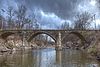
The Bucher bridge over Eight Mile Creek northwest of Rock, Kansas is 44 feet long and 13 feet wide. Completed in 1905 by Walter Sharp of El Dorado and constructed of solid concrete.
5 W. H. Coffin House
W. H. Coffin House W. H. Coffin House, Winfield, Kansas.jpg
W. H. Coffin House
August 28, 2003
(#03000839)
421 E. 11th Ave.
37°14′18″N96°59′30″W / 37.238333°N 96.991667°W / 37.238333; -96.991667 (W. H. Coffin House)
Winfield Built in 1892, the W. H. Coffin House is an example of Queen Anne style architecture in the United States popular from about 1880 to 1900.
6 Cowley County National Bank Building
Cowley County National Bank Building Cowley County National Bank Building.JPG
Cowley County National Bank Building
August 11, 1983
(#83000421)
820-822 Main St.
37°14′25″N96°59′47″W / 37.240278°N 96.996389°W / 37.240278; -96.996389 (Cowley County National Bank Building)
Winfield 
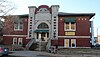
Completed in 1886 and first occupied as the Farmers’ Bank. From 1891 until 1922, it was operated at the Cowley County National Bank. The building was designed in the style of Second Empire architecture by local architects by W. A. Ritchie and W.J. Ritchie. A boundary increase was approved on June 3, 2021.
7 East Badger Creek Culvert
East Badger Creek Culvert Thomson Bridge.jpg
East Badger Creek Culvert
December 29, 2015
(#15000936)
182nd Rd. approx. .3 mi. E. of 131st Rd.
37°12′55″N96°54′33″W / 37.215361°N 96.909259°W / 37.215361; -96.909259 (East Badger Creek Culvert)
Winfield
8 Esch's Spur Bridge
Esch's Spur Bridge Esch's spur bridge.jpg
Esch's Spur Bridge
July 2, 1985
(#85001423)
3 miles south and 3 miles west of Dexter
37°08′07″N96°46′52″W / 37.135278°N 96.781111°W / 37.135278; -96.781111 (Esch's Spur Bridge)
Dexter
9 Grace Methodist Episcopal Church
Grace Methodist Episcopal Church Grace Methodist Episcopal Church (Winfield, Kansas).JPG
Grace Methodist Episcopal Church
November 15, 2005
(#05001241)
320 College St.
37°14′48″N96°58′39″W / 37.246667°N 96.9775°W / 37.246667; -96.9775 (Grace Methodist Episcopal Church)
Winfield
10 W. P. Hackney House
W. P. Hackney House W.P. Hackney House, Winfield, Kansas.jpg
W. P. Hackney House
March 7, 1973
(#73000749)
417 E. 10th St.
37°14′21″N96°59′31″W / 37.239167°N 96.991944°W / 37.239167; -96.991944 (W. P. Hackney House)
Winfield 
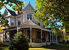
Completed in 1886, the three-story limestone house is an example of Vernacular architecture. It was home to W. P. Hackney, a prominent lawyer and politician.
11 Magnolia Ranch March 7, 1973
(#73000750)
10 miles southeast of Winfield on U.S. Route 77
37°08′03″N96°55′23″W / 37.134167°N 96.923056°W / 37.134167; -96.923056 (Magnolia Ranch)
Winfield
12 Old Arkansas City High School
Old Arkansas City High School Old Arkansas City High School.JPG
Old Arkansas City High School
November 21, 1974
(#74000824)
300 W. Central St.
37°03′45″N97°02′29″W / 37.0625°N 97.041389°W / 37.0625; -97.041389 (Old Arkansas City High School)
Arkansas City Now used by Cowley Community College.
13 Pettit Cleaners Building
Pettit Cleaners Building Pettit Cleaners Building.JPG
Pettit Cleaners Building
January 5, 2005
(#04001427)
114 E. 8th Ave.
37°14′29″N96°59′45″W / 37.241389°N 96.995833°W / 37.241389; -96.995833 (Pettit Cleaners Building)
Winfield
14 Pilgrim Congregational Church
Pilgrim Congregational Church Pilgrim Congregational Church (Arkansas City, Kansas).JPG
Pilgrim Congregational Church
June 8, 2005
(#05000545)
101 N. Third St.
37°03′45″N97°02′33″W / 37.0625°N 97.0425°W / 37.0625; -97.0425 (Pilgrim Congregational Church)
Arkansas City
15 St. John's Lutheran College-Baden Hall
St. John's Lutheran College-Baden Hall St. John's Lutheran College-Baden Hall.JPG
St. John's Lutheran College-Baden Hall
January 18, 2011
(#10001138)
Seventh Ave. and College St.
37°14′34″N96°58′42″W / 37.242778°N 96.978333°W / 37.242778; -96.978333 (St. John's Lutheran College-Baden Hall)
Winfield
16 St. John's Lutheran College Girls Dormitory
St. John's Lutheran College Girls Dormitory St. John's Lutheran College Girls Dormitory.JPG
St. John's Lutheran College Girls Dormitory
January 28, 2002
(#01001544)
6th Ave. and Gary St.
37°14′36″N96°58′51″W / 37.243333°N 96.980833°W / 37.243333; -96.980833 (St. John's Lutheran College Girls Dormitory)
Winfield
17 Silver Creek Bridge
Silver Creek Bridge Andes bridge.jpg
Silver Creek Bridge
January 30, 1987
(#86003270)
East of Winfield
37°12′03″N96°50′34″W / 37.200833°N 96.842778°W / 37.200833; -96.842778 (Silver Creek Bridge)
Winfield
18 Spring Creek Stone Arch Bridge October 10, 2023
(#100009416)
Located in West Creswell Township, 2.5 mi. west of Arkansas City on 262nd Rd.
Coordinates missing
Arkansas City vicinity
19 Strother Field Tetrahedron Wind Indicator April 14, 2015
(#15000143)
22215 Tupper St. (Strother Field)
37°10′09″N97°02′17″W / 37.1692°N 97.0381°W / 37.1692; -97.0381 (Strother Field Tetrahedron Wind Indicator)
Winfield
20 Weigle Barn October 11, 2016
(#16000702)
14097 189th Rd.
37°17′02″N96°48′41″W / 37.283761°N 96.811380°W / 37.283761; -96.811380 (Weigle Barn)
Burden
21 West Dormitory-St. John's College
West Dormitory-St. John's College West Dormitory St. John's College, Winfield, Kansas.jpg
West Dormitory-St. John's College
December 13, 1991
(#91001769)
1415 E. Sixth Ave.
37°13′50″N96°46′38″W / 37.230556°N 96.777222°W / 37.230556; -96.777222 (West Dormitory-St. John's College)
Winfield Rehwinkel Hall, originally known as the West Dormitory, was completed in 1916 as a three-story building with raised basement, facing south on the former St. John's College (Kansas) campus.
22 Wilmer House
Wilmer House Wilmer House.JPG
Wilmer House
January 31, 2008
(#07001477)
1310 E. 9th Ave.
37°14′27″N96°58′52″W / 37.240833°N 96.981111°W / 37.240833; -96.981111 (Wilmer House)
Winfield
23 Winfield Fox Theatre January 6, 2022
(#100007282)
1007 Main St.
37°14′20″N96°59′50″W / 37.2389°N 96.9973°W / 37.2389; -96.9973 (Winfield Fox Theatre)
Winfield
24 Winfield National Bank Building
Winfield National Bank Building Winfield National Bank Building.JPG
Winfield National Bank Building
January 20, 2012
(#11001031)
901 Main St.
37°14′25″N96°59′51″W / 37.240161°N 96.997572°W / 37.240161; -96.997572 (Winfield National Bank Building)
Winfield
25 Winfield Public Carnegie Library
Winfield Public Carnegie Library Winfield Public Carnegie Library.JPG
Winfield Public Carnegie Library
January 11, 1988
(#87002230)
1001 Millington St.
37°14′19″N96°59′47″W / 37.238611°N 96.996389°W / 37.238611; -96.996389 (Winfield Public Carnegie Library)
Winfield

Former listings

[3] Name on the RegisterImageDate listedDate removedLocationCity or townDescription
1 Gladstone Hotel August 26, 1983
(#83000422)
February 25, 2004N. Summit Street
Arkansas City
2 George W. Yount Barn
George W. Yount Barn George W. Yount Barn.JPG
George W. Yount Barn
May 16, 1997
(#97000436)
December 29, 20151 mile east of U.S. Route 77, approximately 2.5 miles north of Winfield
37°16′49″N96°59′12″W / 37.280278°N 96.986667°W / 37.280278; -96.986667 (George W. Yount Barn)
Winfield

See also

Related Research Articles

<span class="mw-page-title-main">National Register of Historic Places listings in Harvey County, Kansas</span>

This is a list of the National Register of Historic Places listings in Harvey County, Kansas.

<span class="mw-page-title-main">National Register of Historic Places listings in Douglas County, Kansas</span>

This is a list of the National Register of Historic Places listings in Douglas County, Kansas.

<span class="mw-page-title-main">National Register of Historic Places listings in Riley County, Kansas</span>

This is a list of the National Register of Historic Places listings in Riley County, Kansas.

<span class="mw-page-title-main">National Register of Historic Places listings in Morris County, Kansas</span>

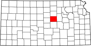
This is a list of the National Register of Historic Places listings in Morris County, Kansas.

<span class="mw-page-title-main">National Register of Historic Places listings in Sedgwick County, Kansas</span>

This is a list of the National Register of Historic Places listings in Sedgwick County, Kansas.

<span class="mw-page-title-main">National Register of Historic Places listings in Wyandotte County, Kansas</span>

The National Register of Historic Places listings in Wyandotte County, Kansas are 43 properties and districts, including one National Historic Landmark. Another two properties have been removed.

<span class="mw-page-title-main">National Register of Historic Places listings in Barton County, Kansas</span>

This is a list of the National Register of Historic Places listings in Barton County, Kansas.

<span class="mw-page-title-main">National Register of Historic Places listings in Chase County, Kansas</span>

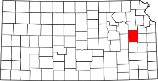
This is a list of the National Register of Historic Places listings in Chase County, Kansas.

<span class="mw-page-title-main">National Register of Historic Places listings in Johnson County, Kansas</span>

This is a list of the National Register of Historic Places listings in Johnson County, Kansas.

<span class="mw-page-title-main">National Register of Historic Places listings in Saline County, Kansas</span>

This is a list of the National Register of Historic Places listings in Saline County, Kansas.

<span class="mw-page-title-main">National Register of Historic Places listings in Crawford County, Kansas</span>

This is a list of the National Register of Historic Places listings in Crawford County, Kansas.

<span class="mw-page-title-main">National Register of Historic Places listings in Labette County, Kansas</span>

This is a list of the National Register of Historic Places listings in Labette County, Kansas.

<span class="mw-page-title-main">National Register of Historic Places listings in Cloud County, Kansas</span>

This is a list of the National Register of Historic Places listings in Cloud County, Kansas.

<span class="mw-page-title-main">National Register of Historic Places listings in Miami County, Kansas</span>

This is a list of the National Register of Historic Places listings in Miami County, Kansas.

<span class="mw-page-title-main">National Register of Historic Places listings in Pottawatomie County, Kansas</span>

This is a list of the National Register of Historic Places listings in Pottawatomie County, Kansas.

<span class="mw-page-title-main">National Register of Historic Places listings in Osage County, Kansas</span>

This is a list of the National Register of Historic Places listings in Osage County, Kansas.

<span class="mw-page-title-main">National Register of Historic Places listings in Mitchell County, Kansas</span>

This is a list of the National Register of Historic Places listings in Mitchell County, Kansas.

<span class="mw-page-title-main">National Register of Historic Places listings in Finney County, Kansas</span>

This is a list of the National Register of Historic Places listings in Finney County, Kansas.

<span class="mw-page-title-main">National Register of Historic Places listings in Ford County, Kansas</span>

This is a list of the National Register of Historic Places listings in Ford County, Kansas.

<span class="mw-page-title-main">National Register of Historic Places listings in Jackson County, Missouri</span>

This is a list of the National Register of Historic Places listings in Jackson County, Missouri.

References

  1. The latitude and longitude information provided in this table was derived originally from the National Register Information System, which has been found to be fairly accurate for about 99% of listings. Some locations in this table may have been corrected to current GPS standards.
  2. National Park Service, United States Department of the Interior, "National Register of Historic Places: Weekly List Actions", retrieved October 6, 2023.
  3. 1 2 Numbers represent an alphabetical ordering by significant words. Various colorings, defined here, differentiate National Historic Landmarks and historic districts from other NRHP buildings, structures, sites or objects.
  4. "National Register Information System". National Register of Historic Places . National Park Service. March 13, 2009.
  5. The eight-digit number below each date is the number assigned to each location in the National Register Information System database, which can be viewed by clicking the number.
  6. Location derived from its NRHP nomination form; the NRIS lists the site as "Address Restricted"