National Register of Historic Places listings in Rice County, Kansas

Last updated

Location of Rice County in Kansas Map of Kansas highlighting Rice County.svg
Location of Rice County in Kansas

This is a list of the National Register of Historic Places listings in Rice County, Kansas.

Contents

This is intended to be a complete list of the properties and districts on the National Register of Historic Places in Rice County, Kansas, United States. The locations of National Register properties and districts for which the latitude and longitude coordinates are included below may be seen on a map. [1] There are 15 properties and districts listed on the National Register in the county, including 1 National Historic Landmark and two former listings.


    This National Park Service list is complete through NPS recent listings posted February 24, 2023. [2]

Map all coordinates using: OpenStreetMap  
Download coordinates as: KML

Current listings

[3] Name on the Register [4] ImageDate listed [5] Location City or townDescription
1 Archeological Site Number 14RC10 July 9, 1982
(#82004887)
9 miles (14 km) northeast of Lyons [6]
Little River A petroglyph site located near the Tobias-Thompson Complex and perhaps related to it [6]
2 Archeological Site Number 14RC11 July 9, 1982
(#82004866)
Address restricted
Little River
3 Cooper Hall May 3, 1974
(#74000845)
N. Broadway Ave.
38°13′18″N98°12′27″W / 38.221667°N 98.2075°W / 38.221667; -98.2075 (Cooper Hall)
Sterling
4 Little Arkansas River Crossing April 5, 2014
(#14000122)
Northeast of the junction of Ave. P and 30th Rd.
38°18′15″N97°56′36″W / 38.304203°N 97.943345°W / 38.304203; -97.943345 (Little Arkansas River Crossing)
Windom Santa Fe Trail Multiple Property Submission
5 Malone Archeological Site June 26, 1972
(#72000523)
Eastern side of Cow Creek, west of Lyons [7] :188
38°21′00″N98°17′24″W / 38.350000°N 98.290000°W / 38.350000; -98.290000 (Malone Archeological Site)
Lyons
6 Rice County Courthouse
Rice County Courthouse Lyons Courthouse (1935) P5310421.jpg
Rice County Courthouse
April 26, 2002
(#02000401)
101 W. Commercial St.
38°20′50″N98°12′13″W / 38.347222°N 98.203611°W / 38.347222; -98.203611 (Rice County Courthouse)
Lyons
7 Rice County Jail and Sheriff's Residence September 30, 2021
(#100007026)
120 East Main St.
38°20′52″N98°12′11″W / 38.3477°N 98.2030°W / 38.3477; -98.2030 (Rice County Jail and Sheriff's Residence)
Lyons
8 Santa Fe Trail-Rice County Trail Segments May 11, 1995
(#95000582)
Bushton Blacktop (FAS Highway 570), ¾ mile north of U.S. Route 56; also 4th Rd. at Av. L, ¾ mile north of U.S. Route 56
38°21′34″N98°25′20″W / 38.359444°N 98.422222°W / 38.359444; -98.422222 (Santa Fe Trail-Rice County Trail Segments)
Chase 4th and L represents a boundary increase of July 17, 2013
9 Santa Fe Trail-Rice County Segment 2 August 6, 2013
(#13000580)
Ave. P, ¾ mile west of 30th Rd.
38°18′15″N97°57′26″W / 38.304251°N 97.957180°W / 38.304251; -97.957180 (Santa Fe Trail-Rice County Segment 2)
Little River Santa Fe Trail Multiple Property Submission
10 Santa Fe Trail-Rice County Segment 3 August 6, 2013
(#13000581)
Address Restricted
Windom Santa Fe Trail Multiple Property Submission
11 Saxman Site May 3, 1976
(#76000837)
0.5 miles (0.80 km) south of Saxman on Cow Creek [7] :192
38°16′26″N98°07′26″W / 38.273889°N 98.123889°W / 38.273889; -98.123889 (Saxman Site)
Saxman
12 Shay Building April 12, 2010
(#10000179)
202 S. Broadway Ave.
38°12′31″N98°12′24″W / 38.208481°N 98.206794°W / 38.208481; -98.206794 (Shay Building)
Sterling
13 Station Little Arkansas May 11, 1995
(#95000583)
5 miles south of U.S. Route 56 on FAS Highway 443, ¾ miles west on gravel road
38°18′10″N97°56′11″W / 38.302778°N 97.936389°W / 38.302778; -97.936389 (Station Little Arkansas)
Windom
14 Sterling Free Public Carnegie Library June 25, 1987
(#87000969)
132 N. Broadway
38°12′38″N98°12′25″W / 38.210486°N 98.206825°W / 38.210486; -98.206825 (Sterling Free Public Carnegie Library)
Sterling Red brick Carnegie library built in 1916, funded by a $10,000 grant
15 Tobias-Thompson Complex
Tobias-Thompson Complex TobiasThompsonComplex1975.jpg
Tobias-Thompson Complex
October 15, 1966
(#66000349)
4 miles southeast of Geneseo
38°27′24″N98°05′31″W / 38.456667°N 98.091944°W / 38.456667; -98.091944 (Tobias-Thompson Complex)
Geneseo

Former listings

[3] Name on the RegisterImageDate listedDate removedLocationCity or townDescription
1 Charles K. Beckett House January 16, 2009
(#08001350)
January 17, 2017210 W. Main
38°12′36″N98°12′31″W / 38.209883°N 98.208581°W / 38.209883; -98.208581 (Charles K. Beckett House)
Sterling
2 Lyons High School June 9, 2005
(#05000556)
September 14, 2018401 S. Douglas Ave.
38°20′47″N98°12′27″W / 38.346389°N 98.2075°W / 38.346389; -98.2075 (Lyons High School)
Lyons

See also

Related Research Articles

<span class="mw-page-title-main">National Register of Historic Places listings in Dickinson County, Kansas</span>

This is a list of the National Register of Historic Places listings in Dickinson County, Kansas.

<span class="mw-page-title-main">National Register of Historic Places listings in Leavenworth County, Kansas</span>

This is a list of the National Register of Historic Places listings in Leavenworth County, Kansas.

<span class="mw-page-title-main">National Register of Historic Places listings in Marion County, Kansas</span>

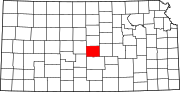
This is a list of the National Register of Historic Places listings in Marion County, Kansas.

<span class="mw-page-title-main">National Register of Historic Places listings in Montgomery County, Kansas</span>

This is a list of the National Register of Historic Places listings in Montgomery County, Kansas.

<span class="mw-page-title-main">National Register of Historic Places listings in McPherson County, Kansas</span>

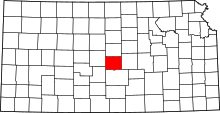
This is a list of the National Register of Historic Places listings in McPherson County, Kansas.

<span class="mw-page-title-main">National Register of Historic Places listings in Big Horn County, Wyoming</span>

This is a list of the National Register of Historic Places listings in Big Horn County, Wyoming.

<span class="mw-page-title-main">National Register of Historic Places listings in Geary County, Kansas</span>

This is a list of the National Register of Historic Places listings in Geary County, Kansas.

<span class="mw-page-title-main">National Register of Historic Places listings in Larimer County, Colorado</span>

This is a list of the National Register of Historic Places listings in Larimer County, Colorado.

<span class="mw-page-title-main">National Register of Historic Places listings in Weld County, Colorado</span>

This is a list of the National Register of Historic Places listings in Weld County, Colorado.

<span class="mw-page-title-main">National Register of Historic Places listings in Waldo County, Maine</span>

This is a list of the National Register of Historic Places listings in Waldo County, Maine.

<span class="mw-page-title-main">National Register of Historic Places listings in Knox County, Nebraska</span>

This is a list of the National Register of Historic Places listings in Knox County, Nebraska.

<span class="mw-page-title-main">National Register of Historic Places listings in Beaverhead County, Montana</span>

This is a list of the National Register of Historic Places listings in Beaverhead County, Montana. It is intended to be a complete list of the properties and districts on the National Register of Historic Places in Beaverhead County, Montana, United States. The locations of National Register properties and districts for which the latitude and longitude coordinates are included below, may be seen in a map.

<span class="mw-page-title-main">National Register of Historic Places listings in Custer County, South Dakota</span>

This is a list of the National Register of Historic Places listings in Custer County, South Dakota.

<span class="mw-page-title-main">National Register of Historic Places listings in Hughes County, South Dakota</span>

This is a list of the National Register of Historic Places listings in Hughes County, South Dakota.

<span class="mw-page-title-main">National Register of Historic Places listings in Pottawatomie County, Kansas</span>

This is a list of the National Register of Historic Places listings in Pottawatomie County, Kansas.

<span class="mw-page-title-main">National Register of Historic Places listings in Carter County, Missouri</span>

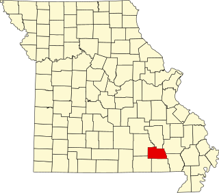
This is a list of the National Register of Historic Places listings in Carter County, Missouri.

<span class="mw-page-title-main">National Register of Historic Places listings in Saline County, Missouri</span>

This is a list of the National Register of Historic Places listings in Saline County, Missouri.

<span class="mw-page-title-main">National Register of Historic Places listings in Shannon County, Missouri</span>

This is a list of the National Register of Historic Places listings in Shannon County, Missouri.

<span class="mw-page-title-main">National Register of Historic Places listings in Cherokee County, Iowa</span>

This is a list of the National Register of Historic Places listings in Cherokee County, Iowa.

<span class="mw-page-title-main">National Register of Historic Places listings in Buena Vista County, Iowa</span>

This is a list of the National Register of Historic Places listings in Buena Vista County, Iowa.

References

  1. The latitude and longitude information provided in this table was derived originally from the National Register Information System, which has been found to be fairly accurate for about 99% of listings. Some locations in this table may have been corrected to current GPS standards.
  2. National Park Service, United States Department of the Interior, "National Register of Historic Places: Weekly List Actions", retrieved February 24, 2023.
  3. 1 2 Numbers represent an alphabetical ordering by significant words. Various colorings, defined here, differentiate National Historic Landmarks and historic districts from other NRHP buildings, structures, sites or objects.
  4. "National Register Information System". National Register of Historic Places . National Park Service. March 13, 2009.
  5. The eight-digit number below each date is the number assigned to each location in the National Register Information System database, which can be viewed by clicking the number.
  6. 1 2 Wedel, Waldo. "A Shield and Spear Petroglyph from Central Kansas: Some Possible Implications". Plains Anthropologist 14.44 (1969): 125-129: 125.
  7. 1 2 Wedel, Waldo. "Chain Mail in Plains Archeology". Plains Anthropologist 20.69 (1975): 187-196.