Raymond, Kansas

Last updated

Raymond, Kansas
Rice County Kansas Incorporated and Unincorporated areas Raymond Highlighted.svg
Location within Rice County and Kansas
Map of Rice Co, Ks, USA.png
Coordinates: 38°16′41″N98°24′52″W / 38.27806°N 98.41444°W / 38.27806; -98.41444 [1]
Country United States
State Kansas
County Rice
Township Raymond
Founded1871
Incorporated 1954
Named for Emmons Raymond
Area
[2]
  Total0.31 sq mi (0.80 km2)
  Land0.31 sq mi (0.80 km2)
  Water0.00 sq mi (0.00 km2)
Elevation
[1]
1,726 ft (526 m)
Population
 (2020) [3]
  Total85
  Density270/sq mi (110/km2)
Time zone UTC-6 (CST)
  Summer (DST) UTC-5 (CDT)
ZIP code
67573
Area code 620
FIPS code 20-58550
GNIS ID 2396327 [1]

Raymond is a city in Rice County, Kansas, United States. [1] It is named after Emmons Raymond, former Director of the Atchison, Topeka and Santa Fe Railway. [4] [5] As of the 2020 census, the population of the city was 85. [3]

Contents

History

For millennia, the land now known as Kansas was inhabited by Native Americans. In 1803, most of modern Kansas was secured by the United States as part of the Louisiana Purchase. In 1854, the Kansas Territory was organized, then in 1861 Kansas became the 34th U.S. state. In 1867, Rice County was founded.

Raymond was founded in 1871, making it the oldest town in Rice County. [4] The first post office in Raymond was established in 1872. [6] At one point in its history Raymond was known as a wild "cowtown" and was a stop on the Santa Fe Railroad, but the town has been in decline since the 1950s.

Geography

According to the United States Census Bureau, the city has a total area of 0.32 square miles (0.83 km2), all of it land. [7]

Area events

Demographics

Historical population
CensusPop.Note
1880 87
1890 13757.5%
1960 143
1970 133−7.0%
1980 132−0.8%
1990 125−5.3%
2000 95−24.0%
2010 79−16.8%
2020 857.6%
U.S. Decennial Census

2010 census

As of the census [8] of 2010, there were 79 people, 39 households, and 20 families residing in the city. The population density was 246.9 inhabitants per square mile (95.3/km2). There were 51 housing units at an average density of 159.4 per square mile (61.5/km2). The racial makeup of the city was 100.0% White.

There were 39 households, of which 15.4% had children under the age of 18 living with them, 48.7% were married couples living together, 2.6% had a male householder with no wife present, and 48.7% were non-families. 38.5% of all households were made up of individuals, and 18% had someone living alone who was 65 years of age or older. The average household size was 2.03 and the average family size was 2.75.

The median age in the city was 52.4 years. 12.7% of residents were under the age of 18; 10.1% were between the ages of 18 and 24; 15.2% were from 25 to 44; 35.4% were from 45 to 64; and 26.6% were 65 years of age or older. The gender makeup of the city was 51.9% male and 48.1% female.

2000 census

As of the census [9] of 2000, there were 95 people, 43 households, and 28 families residing in the city. The population density was 299.3 inhabitants per square mile (115.6/km2). There were 51 housing units at an average density of 160.7 per square mile (62.0/km2). The racial makeup of the city was 94.74% White, 1.05% Asian, 1.05% from other races, and 3.16% from two or more races. Hispanic or Latino of any race were 5.26% of the population.

There were 43 households, out of which 20.9% had children under the age of 18 living with them, 48.8% were married couples living together, 11.6% had a female householder with no husband present, and 32.6% were non-families. 32.6% of all households were made up of individuals, and 20.9% had someone living alone who was 65 years of age or older. The average household size was 2.21 and the average family size was 2.72.

In the city, the population was spread out, with 22.1% under the age of 18, 4.2% from 18 to 24, 20.0% from 25 to 44, 29.5% from 45 to 64, and 24.2% who were 65 years of age or older. The median age was 46 years. For every 100 females, there were 97.9 males. For every 100 females age 18 and over, there were 111.4 males.

The median income for a household in the city was $20,000, and the median income for a family was $28,750. Males had a median income of $13,125 versus $12,500 for females. The per capita income for the city was $12,654. There were 23.1% of families and 33.7% of the population living below the poverty line, including 87.5% of under eighteens and 5.9% of those over 64.

Education

The community is served by Chase–Raymond USD 401 public school district.

See also

Related Research Articles

<span class="mw-page-title-main">Harris, Kansas</span> Unincorporated community in Anderson County, Kansas

Harris is an unincorporated community in Anderson County, Kansas, United States. As of the 2020 census, the population of the community and nearby areas was 47.

<span class="mw-page-title-main">Olmitz, Kansas</span> City in Barton County, Kansas

Olmitz is a city in Barton County, Kansas, United States. As of the 2020 census, the population of the city was 90.

<span class="mw-page-title-main">Oak Hill, Kansas</span> City in Clay County, Kansas

Oak Hill is a city in Clay County, Kansas, United States. As of the 2020 census, the population of the city was 24.

<span class="mw-page-title-main">Aurora, Kansas</span> City in Cloud County, Kansas

Aurora is a city in Cloud County, Kansas, United States. As of the 2020 census, the population of the city was 56.

<span class="mw-page-title-main">Hepler, Kansas</span> City in Crawford County, Kansas

Hepler is a city in Crawford County, Kansas, United States. As of the 2020 census, the population of the city was 90.

<span class="mw-page-title-main">Webber, Kansas</span> City in Jewell County, Kansas

Webber is a city in Jewell County, Kansas, United States. As of the 2020 census, the population of the city was 30.

<span class="mw-page-title-main">Westwood Hills, Kansas</span> City in Kansas, United States

Westwood Hills is a city in Johnson County, Kansas, United States. As of the 2020 census, the population of the city was 400. It is the most densely populated city in the Kansas City Metropolitan Area at 6,240 people per square mile. It borders Kansas City, Missouri.

<span class="mw-page-title-main">Penalosa, Kansas</span> City in Kingman County, Kansas

Penalosa is a city in Kingman County, Kansas, United States. As of the 2020 census, the population of the city was 18.

<span class="mw-page-title-main">Spivey, Kansas</span> City in Kingman County, Kansas

Spivey is a city in Kingman County, Kansas, United States. As of the 2020 census, the population of the city was 61.

<span class="mw-page-title-main">Meade, Kansas</span> City in Meade County, Kansas

Meade is a city in and the county seat of Meade County, Kansas, United States. As of the 2020 census, the population of the city was 1,505.

<span class="mw-page-title-main">McDonald, Kansas</span> City in Rawlins County, Kansas

McDonald is a city in Rawlins County, Kansas, United States. As of the 2020 census, the population of the city was 113.

<span class="mw-page-title-main">Alden, Kansas</span> City in Rice County, Kansas

Alden is a city in Rice County, Kansas, United States. As of the 2020 census, the population of the city was 122.

<span class="mw-page-title-main">Chase, Kansas</span> City in Rice County, Kansas

Chase is a city in Rice County, Kansas, United States. As of the 2020 census, the population of the city was 396.

<span class="mw-page-title-main">Frederick, Kansas</span> City in Rice County, Kansas

Frederick is a city in Rice County, Kansas, United States. As of the 2020 census, the population of the city was 8.

<span class="mw-page-title-main">Geneseo, Kansas</span> City in Rice County, Kansas

Geneseo is a city in Rice County, Kansas, United States. As of the 2020 census, the population of the city was 236.

<span class="mw-page-title-main">Clearwater, Kansas</span> City in Sedgwick County, Kansas

Clearwater is a city in Sedgwick County, Kansas, United States. As of the 2020 census, the population of the city was 2,653.

<span class="mw-page-title-main">Park City, Kansas</span> City in Sedgwick County, Kansas

Park City is a city in Sedgwick County, Kansas, United States and a suburb of Wichita. As of the 2020 census, the population of the city was 8,333.
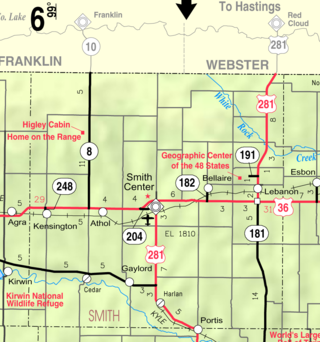
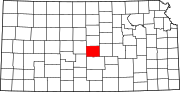
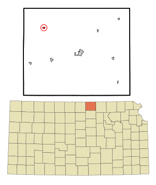
<span class="mw-page-title-main">Seward, Kansas</span> City in Stafford County, Kansas

Seward is a city in Stafford County, Kansas, United States. As of the 2020 census, the population of the city was 41.

<span class="mw-page-title-main">Mayfield, Kansas</span> City in Sumner County, Kansas

Mayfield is a city in Sumner County, Kansas, United States. As of the 2020 census, the population of the city was 75.

<span class="mw-page-title-main">Vining, Kansas</span> City in Clay and Washington Counties in Kansas

Vining is a city in Clay and Washington counties in Kansas, United States. As of the 2020 census, the population of the city was 43.

References

  1. 1 2 3 4 U.S. Geological Survey Geographic Names Information System: Raymond, Kansas
  2. "2019 U.S. Gazetteer Files". United States Census Bureau. Retrieved July 24, 2020.
  3. 1 2 "Profile of Raymond, Kansas in 2020". United States Census Bureau. Archived from the original on March 29, 2022. Retrieved March 29, 2022.
  4. 1 2 Raymond - History
  5. The Atchison, Topeka, and Santa Fe Railway and Auxiliary Companies - Annual Meetings, and Directors and Officers; January 1, 1902
  6. "Kansas Post Offices, 1828-1961". Kansas Historical Society. Archived from the original on October 9, 2013. Retrieved June 22, 2014.
  7. "US Gazetteer files 2010". United States Census Bureau. Archived from the original on January 25, 2012. Retrieved July 6, 2012.
  8. "U.S. Census website". United States Census Bureau . Retrieved July 6, 2012.
  9. "U.S. Census website". United States Census Bureau . Retrieved January 31, 2008.

Further reading