National Register of Historic Places listings in Pawnee County, Kansas

Last updated
Location of Pawnee County in Kansas Map of Kansas highlighting Pawnee County.svg
Location of Pawnee County in Kansas

This is a list of the National Register of Historic Places listings in Pawnee County, Kansas. It is intended to be a complete list of the properties and districts on the National Register of Historic Places in Pawnee County, Kansas, United States. The locations of National Register properties and districts for which the latitude and longitude coordinates are included below, may be seen in an online map.

National Register of Historic Places federal list of historic sites in the United States

The National Register of Historic Places (NRHP) is the United States federal government's official list of districts, sites, buildings, structures, and objects deemed worthy of preservation for their historical significance. A property listed in the National Register, or located within a National Register Historic District, may qualify for tax incentives derived from the total value of expenses incurred preserving the property.

Pawnee County, Kansas County in the United States

Pawnee County is a county located in the U.S. state of Kansas. As of the 2010 census, the county population was 6,973. The largest city and county seat is Larned.

Kansas State of the United States of America

Kansas is a U.S. state in the Midwestern United States. Its capital is Topeka and its largest city is Wichita, with its most populated county being Johnson County. Kansas is bordered by Nebraska on the north; Missouri on the east; Oklahoma on the south; and Colorado on the west. Kansas is named after the Kansas River, which in turn was named after the Kansa Native Americans who lived along it banks. The tribe's name is often said to mean "people of the (south) wind" although this was probably not the term's original meaning. For thousands of years, what is now Kansas was home to numerous and diverse Native American tribes. Tribes in the eastern part of the state generally lived in villages along the river valleys. Tribes in the western part of the state were semi-nomadic and hunted large herds of bison.

Contents

There are 8 properties and districts listed on the National Register in the county.

This National Park Service list is complete through NPS recent listings posted May 18, 2018. [1]

Current listings

Map all coordinates using: OpenStreetMap  ·  Google Maps
Download coordinates as: KML  ·  GPX
[2] Name on the Register [3] Image Date listed [4] Location City or town Description
1 Babbitt-Doerr House
Babbitt-Doerr House Babbitt-Doerr House NRHP 95000477 Pawnee County, KS.jpg
Babbitt-Doerr House
April 20, 1995
(#95000477)
423 W. 5th St.
38°10′41″N99°06′11″W / 38.178056°N 99.103056°W / 38.178056; -99.103056 (Babbitt-Doerr House)
Larned
2 Coon Creek Crossing on the Santa Fe Trail (Wet Route) Upload image July 17, 2013
(#13000493)
1.5 miles southwest of Garfield on US 56
38°03′55″N99°15′32″W / 38.065363°N 99.258960°W / 38.065363; -99.258960 (Coon Creek Crossing on the Santa Fe Trail (Wet Route))
Garfield Santa Fe Trail Multiple Property Submission
3 Fort Larned National Historic Site
Fort Larned National Historic Site Fort Larned quartermaster's building.jpg
Fort Larned National Historic Site
October 15, 1966
(#66000107)
6 miles west of Larned on U.S. Route 156
38°09′24″N99°13′36″W / 38.156667°N 99.226667°W / 38.156667; -99.226667 (Fort Larned National Historic Site)
Larned
4 Lewis Site Upload image May 3, 1976
(#76000836)
Address restricted
Larned
5 Ooten House Upload image March 2, 2001
(#01000188)
507 W. 15th St.
38°11′21″N99°06′14″W / 38.189167°N 99.103889°W / 38.189167; -99.103889 (Ooten House)
Larned
6 Patterson House Upload image March 2, 2001
(#01000189)
841 W. 8th St.
38°10′53″N99°06′32″W / 38.181389°N 99.108889°W / 38.181389; -99.108889 (Patterson House)
Larned
7 Pawnee Fork Crossing (Santa Fe Trail Dry Route) and Boyd's Ranch Site Upload image July 17, 2013
(#13000494)
Address Restricted
Larned Santa Fe Trail Multiple Property Submission
8 Township Line Bridge Upload image July 2, 1985
(#85001442)
Off U.S. Route 156, 3 miles west of Rozel
38°12′18″N99°27′35″W / 38.205°N 99.459722°W / 38.205; -99.459722 (Township Line Bridge)
Rozel

See also

National Register of Historic Places listings in Kansas Wikimedia list article

There are over 1,400 buildings, sites, districts, and objects in Kansas listed on the National Register of Historic Places in Kansas. NRHP listings appear in 101 of the state's 105 counties.

Related Research Articles

National Register of Historic Places listings in Dickinson County, Kansas Wikimedia list article

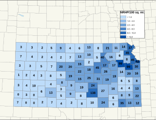
This is a list of the National Register of Historic Places listings in Dickinson County, Kansas.

National Register of Historic Places listings in Leavenworth County, Kansas Wikimedia list article

This is a list of the National Register of Historic Places listings in Leavenworth County, Kansas.

National Register of Historic Places listings in Douglas County, Kansas Wikimedia list article

This is a list of the National Register of Historic Places listings in Douglas County, Kansas.

National Register of Historic Places listings in Morris County, Kansas Wikimedia list article

This is a list of the National Register of Historic Places listings in Morris County, Kansas.

National Register of Historic Places listings in Sedgwick County, Kansas Wikimedia list article

This is a list of the National Register of Historic Places listings in Sedgwick County, Kansas.

National Register of Historic Places listings in Shawnee County, Kansas Wikimedia list article

This is a list of the National Register of Historic Places listings in Shawnee County, Kansas.

National Register of Historic Places listings in Wyandotte County, Kansas Wikimedia list article

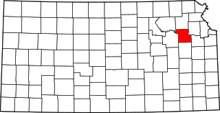
This is a list of the National Register of Historic Places listings in Wyandotte County, Kansas.

National Register of Historic Places listings in Johnson County, Kansas Wikimedia list article

This is a list of the National Register of Historic Places listings in Johnson County, Kansas.

National Register of Historic Places listings in McPherson County, Kansas Wikimedia list article

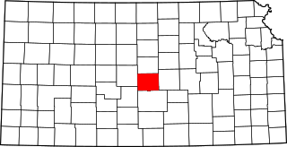
This is a list of the National Register of Historic Places listings in McPherson County, Kansas.

National Register of Historic Places listings in Rice County, Kansas Wikimedia list article

This is a list of the National Register of Historic Places listings in Rice County, Kansas.

National Register of Historic Places listings in Pawnee County, Oklahoma Wikimedia list article

This is a list of the National Register of Historic Places listings in Pawnee County, Oklahoma.

National Register of Historic Places listings in Wilson County, Kansas Wikimedia list article

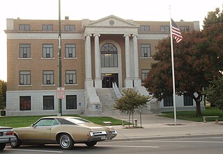
This is a list of the National Register of Historic Places listings in Wilson County, Kansas. It is intended to be a complete list of the properties and districts on the National Register of Historic Places in Wilson County, Kansas, United States. The locations of National Register properties and districts for which the latitude and longitude coordinates are included below, may be seen in an online map.

National Register of Historic Places listings in Stafford County, Kansas Wikimedia list article

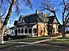
This is a list of the National Register of Historic Places listings in Stafford County, Kansas. It is intended to be a complete list of the properties and districts on the National Register of Historic Places in Stafford County, Kansas, United States. The locations of National Register properties and districts for which the latitude and longitude coordinates are included below, may be seen in an online map.

National Register of Historic Places listings in Harper County, Kansas Wikimedia list article

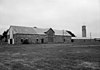
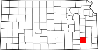
This is a list of the National Register of Historic Places listings in Harper County, Kansas. It is intended to be a complete list of the properties and districts on the National Register of Historic Places in Harper County, Kansas, United States. The locations of National Register properties and districts for which the latitude and longitude coordinates are included below, may be seen in an online map.

National Register of Historic Places listings in Morton County, Kansas Wikimedia list article

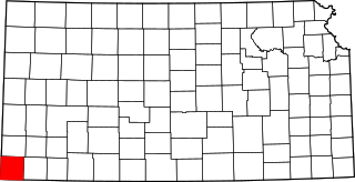
This is a list of the National Register of Historic Places listings in Morton County, Kansas. It is intended to be a complete list of the properties and districts on the National Register of Historic Places in Morton County, Kansas, United States. The locations of National Register properties and districts for which the latitude and longitude coordinates are included below, may be seen in an online map.

National Register of Historic Places listings in Neosho County, Kansas Wikimedia list article

This is a list of the National Register of Historic Places listings in Neosho County, Kansas. It is intended to be a complete list of the properties and districts on the National Register of Historic Places in Neosho County, Kansas, United States. The locations of National Register properties and districts for which the latitude and longitude coordinates are included below, may be seen in an online map.

National Register of Historic Places listings in Ness County, Kansas Wikimedia list article

This is a list of the National Register of Historic Places listings in Ness County, Kansas. It is intended to be a complete list of the properties and districts on the National Register of Historic Places in Ness County, Kansas, United States. The locations of National Register properties and districts for which the latitude and longitude coordinates are included below, may be seen in an online map.

National Register of Historic Places listings in Pratt County, Kansas Wikimedia list article

This is a list of the National Register of Historic Places listings in Pratt County, Kansas. It is intended to be a complete list of the properties and districts on the National Register of Historic Places in Pratt County, Kansas, United States. The locations of National Register properties and districts for which the latitude and longitude coordinates are included below, may be seen in an online map.

National Register of Historic Places listings in Trego County, Kansas Wikimedia list article

This is a list of the National Register of Historic Places listings in Trego County, Kansas. It is intended to be a complete list of the properties and districts on the National Register of Historic Places in Trego County, Kansas, United States. The locations of National Register properties and districts for which the latitude and longitude coordinates are included below, may be seen in an online map.

National Register of Historic Places listings in Washington County, Kansas Wikimedia list article

This is a list of the National Register of Historic Places listings in Washington County, Kansas. It is intended to be a complete list of the properties and districts on the National Register of Historic Places in Washington County, Kansas, United States. The locations of National Register properties and districts for which the latitude and longitude coordinates are included below, may be seen in an online map.

References

  1. "National Register of Historic Places: Weekly List Actions". National Park Service, United States Department of the Interior. Retrieved on May 18, 2018.
  2. Numbers represent an ordering by significant words. Various colorings, defined here, differentiate National Historic Landmarks and historic districts from other NRHP buildings, structures, sites or objects.
  3. National Park Service (2010-07-09). "National Register Information System". National Register of Historic Places . National Park Service.
  4. The eight-digit number below each date is the number assigned to each location in the National Register Information System database, which can be viewed by clicking the number.