Race Rock Light is a lighthouse on Race Rock Reef, a dangerous set of rocks on Long Island Sound southwest of Fishers Island, New York and the site of many shipwrecks. It is currently owned and maintained by the New London Maritime Society as part of the National Historic Lighthouse Preservation Act program.

The County Line Bowstring is a bridge located near unincorporated Hollis, Kansas, United States, that is listed on the National Register of Historic Places. It spans West Creek on the border between Cloud and Republic counties and has a wooden deck with a bowstring pony truss.

The Black Squirrel Creek Bridge carries U.S. 24 over Black Squirrel Creek in El Paso County, Colorado. Prior to 2012, it was locally known as the "green bridge" or "old green bridge"—a historic single-span, Parker through truss bridge that was completed in 1935 and listed on the National Register of Historic Places in 2002. Because it no longer met highway safety standards, the bridge was dismantled and replaced by a newer span in 2012.

The S Bridge is a historic stone arch bridge, spanning Salt Fork about 4 miles (6.4 km) east of Old Washington, Ohio. Built in 1828, it is one of the best-preserved surviving bridges built for the westward expansion of the National Road from Wheeling, West Virginia to Columbus, Ohio. S bridges derive their name from the sharply curving approaches to the span. The bridge was designated a National Historic Landmark in 1964. The bridge is closed to traffic, and may be seen from Blend Road on the north and Rhinehart Road on the south.

The 650-foot (200 m) Dale Creek Crossing, completed in 1868 in southeastern Wyoming Territory, presented engineers of the United States' first transcontinental railroad one of their most difficult challenges. Dale Creek Bridge, the longest bridge on the Union Pacific Railroad (UP), reached 150 feet (46 m) above Dale Creek, two miles (3.2 km) west of Sherman, Wyoming. The eastern approach to the bridge site, near the highest elevation on the UP, 8,247 feet (2,514 m) above sea level, required cutting through granite for nearly a mile. Solid rock also confronted workers on the west side of the bridge where they made a cut one mile (1.6 km) in length.

The Zion – Mount Carmel Highway is a 25-mile (40 km) long road in Utah in the US, with a 1.1-mile (1.8 km) long tunnel. The road runs from the entrance to Zion National Park eastward to Mount Carmel Junction with U.S. Route 89 as a portion of Utah State Route 9. The road became part of a loop tour of Zion, Bryce Canyon, Cedar Breaks and the North Rim of Grand Canyon National Park.

The Rio Puerco Bridge is a Parker through truss bridge located on historic U.S. Route 66 (US 66), crossing the Rio Puerco, that was built in 1933. It is located approximately 19 miles (30 km) west of Albuquerque, New Mexico.

The St. Andrews Creek Bridge was built in 1930-31 as part of the West Side Road in Mount Rainier National Park. The bridge spans 26 feet (7.9 m) and is almost 34 feet (10 m) wide, carrying a two-lane road on a stone-faced concrete bridge. The West Side Road was planned to link the Nisqually and Carbon River entrances to the park, but only 13 miles (21 km) were completed in six years.

The Hammond Covered Bridge is a Town lattice covered bridge spanning Otter Creek in Pittsford, Vermont. The bridge was built in 1842 by Asa Norse, and originally carried Kendall Hill Road, which now passes just to its south. The bridge was added to the National Register of Historic Places on January 21, 1974.

The Old US 41–Backwater Creek Bridge is a bridge located on an abandoned section of US Highway 41 (US 41) over Backwater Creek in Baraga Township, Michigan. It was listed on the National Register of Historic Places in 1999.

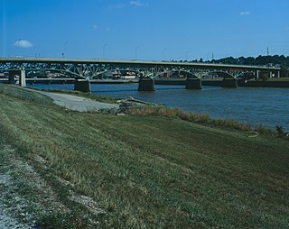
The Jefferson Street Viaduct is an historic structure located in Ottumwa, Iowa, United States. The riveted Warren deck truss bridge was completed in 1936. It was listed on the National Register of Historic Places in 1998 as a part of the Highway Bridges of Iowa MPS.

The Ames Creek Bridge is an historic structure located northeast of DeWitt, Iowa, United States in rural Clinton County. It is an early example of concrete bridge design prior to the codification of standards by the state highway commission. The bridge was listed on the National Register of Historic Places in 1981.

The Dinkey Creek Bridge, also known as Fresno County Bridge No. 42C-04, is a single-span, timber bowstring arch truss bridge that crosses Dinkey Creek in Fresno County, California, within Sierra National Forest. Built in 1938, it closed to automobile traffic in 1965 and was renovated in 1988 to replace rotting timbers. Designed by T.K. May, it was built by the U.S. Forest Service with Civilian Conservation Corps (CCC) labor. The structure was listed on the National Register of Historic Places in 1996.

South Dakota Dept. of Transportation Bridge No. 49-095-190 is a historic bridge in rural Miner County, South Dakota. It carries a local road over Rock Creek, about 6 miles (9.7 km) south and 6.5 miles (10.5 km) west of Howard. Built in 1917, it is the longest pre-1920 concrete slab bridge in the state. Bridges from this time predate the standardization in the methods and use of concrete in bridge construction, and are relatively rare. The bridge consists of a single span 27 feet (8.2 m) in length, with a solid concrete parapet as a railing. The concrete is suffering from spalling.

The South Dakota Dept. of Transportation Bridge No. 30-257-400 is a historic bridge in rural Hand County, South Dakota. It is located 14 miles (23 km) south of Miller and 9.7 miles (15.6 km) east, and carries a local road over Sand Creek. The bridge is a single-span steel beam stringer bridge, resting on I-beam pile abutments with concrete wings. The bridge is 26 feet (7.9 m) long. Built in 1917, it was one of the first bridges built in the county by county employees, rather than by hired bridge companies, and predates the formation of state highway department by two years.

The West Sixth Street Bridge is a historic stone arch bridge in downtown Austin, Texas. Built in 1887, the bridge is one of the state's oldest masonry arch bridges. It is located at the site of the first bridge in Austin, carrying Sixth Street across Shoal Creek to link the western and central parts of the old city. The bridge was added to the National Register of Historic Places in 2014.

The Brush Creek Bridge, near Coyville, Kansas, was built in 1930. It was listed on the National Register of Historic Places in 1985.

The Bridge over Fountain Creek which was built to bring U.S. Route 24 (US 24) over Fountain Creek, approximately 0.5 miles (0.80 km) north of Manitou Springs, Colorado, was built in 1932. It now carries US 24 Business. It is an open spandrel deck arch span. It was listed on the National Register of Historic Places in 1985.

The New Salem Covered Bridge, near Commerce, Georgia, is a multiple kingpost truss covered bridge built in 1915. It was listed on the National Register of Historic Places in 1975.

The Douglas Crossing Bridge, near Granada, Colorado, was built in 1936 as a Works Progress Administration project. It was listed on the National Register of Historic Places in 1985.


