Geuda Springs, Kansas

Last updated

Geuda Springs, Kansas
Sumner County Kansas Incorporated and Unincorporated areas Geuda Springs Highlighted.svg
Location within Sumner County and Kansas
Map of Sumner Co, Ks, USA.png
Coordinates: 37°06′41″N97°09′02″W / 37.11139°N 97.15056°W / 37.11139; -97.15056 [1]
Country United States
State Kansas
Counties Cowley, Sumner
Founded1870s
Incorporated 1884
Named for Nearby mineral spring
Area
[2]
  Total0.34 sq mi (0.88 km2)
  Land0.34 sq mi (0.88 km2)
  Water0.00 sq mi (0.00 km2)
Elevation
[1]
1,135 ft (346 m)
Population
 (2020) [3]
  Total158
  Density460/sq mi (180/km2)
Time zone UTC-6 (CST)
  Summer (DST) UTC-5 (CDT)
ZIP code
67051
Area code 620
FIPS code 20-26200
GNIS ID 2394886 [1]

Geuda Springs is a city in Cowley and Sumner counties in the U.S. state of Kansas. [1] As of the 2020 census, the population of the city was 158. [3]

Contents

History

1915 Railroad Map of Sumner County Stouffer's Railroad Map of Kansas 1915-1918 Sumner County.png
1915 Railroad Map of Sumner County

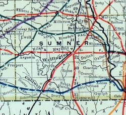
On the line between Cowley and Sumner counties is a remarkable group of salt springs that each put out 100 to 450 gallons per hour and have been known since the earliest settlement of that region. These springs are on a branch of the St. Louis & San Francisco railroad, a little to the north of the town of Geuda Springs and about 7 miles (11 km) from Arkansas City. The waters from these springs infiltrate the waters of the nearby creeks. A lake formed by the creek near these springs has been greatly enlarged by damming the creek and now covers about 50 acres (200,000 m2), making it the largest body of salt water in the state. Geuda is said to be an Indian word, Ge-u-da, meaning healing springs, and the place must have been a well known stopping place with the Indians. Many improvements were made at the springs during the late 1880s, including a bath-house and hotel, lake improvements, and new automobile access. Much of the water has been bottled and shipped to points in Kansas and adjoining states. About 1890, a dam with a flume outlet was built across the salt marsh just north of the springs, which filled the marsh with water and created a lake large enough for recreational boating. [4]

Later in the 1900s, the population of Geuda Springs slowly declined. During the 1950s, Geuda Springs had a bar which featured slot machines, dancing and music. A volunteer fire department exists to protect the town and the surrounding area but primary fire protection is provided by Arkansas City. In the 1990s, a new community center was built for the residents. It is surrounded by homes over 80 years of age and an old church building. Geuda Springs has a cemetery to the northwest of town with tombstones dating to the 1870s. One notable gunfighter Luke Short, died in Geuda Springs in 1893 of congestive heart failure.

Geography

According to the United States Census Bureau, the city has a total area of 0.35 square miles (0.91 km2), all of it land. [5]

Demographics

Historical population
CensusPop.Note
1890 355
1900 218−38.6%
1910 25416.5%
1920 2664.7%
1930 34027.8%
1940 275−19.1%
1950 245−10.9%
1960 223−9.0%
1970 2230.0%
1980 217−2.7%
1990 2190.9%
2000 212−3.2%
2010 185−12.7%
2020 158−14.6%
U.S. Decennial Census

2020 census

The 2020 United States census counted 158 people, 71 households, and 44 families in Geuda Springs. [6] [7] The population density was 459.3 per square mile (177.3/km2). There were 80 housing units at an average density of 232.6 per square mile (89.8/km2). [7] [8] The racial makeup was 85.44% (135) white or European American (85.44% non-Hispanic white), 1.27% (2) black or African-American, 3.16% (5) Native American or Alaska Native, 0.63% (1) Asian, 0.0% (0) Pacific Islander or Native Hawaiian, 1.27% (2) from other races, and 8.23% (13) from two or more races. [9] Hispanic or Latino of any race was 0.63% (1) of the population. [10]

Of the 71 households, 26.8% had children under the age of 18; 46.5% were married couples living together; 14.1% had a female householder with no spouse or partner present. 33.8% of households consisted of individuals and 16.9% had someone living alone who was 65 years of age or older. [7] The average household size was 1.9 and the average family size was 2.5. [11] The percent of those with a bachelor’s degree or higher was estimated to be 5.1% of the population. [12]

21.5% of the population was under the age of 18, 5.1% from 18 to 24, 24.7% from 25 to 44, 29.1% from 45 to 64, and 19.6% who were 65 years of age or older. The median age was 43.5 years. For every 100 females, there were 90.4 males. [7] For every 100 females ages 18 and older, there were 87.9 males. [7]

The 2016-2020 5-year American Community Survey estimates show that the median household income was $43,942 (with a margin of error of +/- $5,575). [13] Males had a median income of $35,313 (+/- $26,750) versus $22,083 (+/- $18,723) for females. The median income for those above 16 years old was $26,250 (+/- $15,039). [14] Approximately, 0.0% of families and 1.5% of the population were below the poverty line, including 0.0% of those under the age of 18 and 0.0% of those ages 65 or over. [15] [16]

2010 census

As of the census [17] of 2010, there were 185 people, 77 households, and 47 families living in the city. The population density was 528.6 inhabitants per square mile (204.1/km2). There were 88 housing units at an average density of 251.4 per square mile (97.1/km2). The racial makeup of the city was 97.8% White, 0.5% Native American, 0.5% Pacific Islander, and 1.1% from two or more races. Hispanic or Latino of any race were 0.5% of the population.

There were 77 households, of which 27.3% had children under the age of 18 living with them, 45.5% were married couples living together, 9.1% had a female householder with no husband present, 6.5% had a male householder with no wife present, and 39.0% were non-families. 35.1% of all households were made up of individuals, and 14.3% had someone living alone who was 65 years of age or older. The average household size was 2.40 and the average family size was 3.04.

The median age in the city was 36.8 years. 25.4% of residents were under the age of 18; 7.5% were between the ages of 18 and 24; 24.3% were from 25 to 44; 26.9% were from 45 to 64; and 15.7% were 65 years of age or older. The gender makeup of the city was 53.5% male and 46.5% female.

2000 census

As of the census [18] of 2000, there were 212 people, 85 households, and 58 families living in the city. The population density was 476.2 inhabitants per square mile (183.9/km2). There were 88 housing units at an average density of 197.7 per square mile (76.3/km2). The racial makeup of the city was 98.58% White, 0.47% Native American, and 0.94% from two or more races. Hispanic or Latino of any race were 1.89% of the population.

There were 85 households, out of which 22.4% had children under the age of 18 living with them, 58.8% were married couples living together, 9.4% had a female householder with no husband present, and 30.6% were non-families. 28.2% of all households were made up of individuals, and 11.8% had someone living alone who was 65 years of age or older. The average household size was 2.49 and the average family size was 3.03.

In the city, the population was spread out, with 21.7% under the age of 18, 12.7% from 18 to 24, 23.1% from 25 to 44, 27.4% from 45 to 64, and 15.1% who were 65 years of age or older. The median age was 41 years. For every 100 females, there were 92.7 males. For every 100 females age 18 and over, there were 90.8 males.

The median income for a household in the city was $38,250, and the median income for a family was $41,250. Males had a median income of $28,750 versus $17,639 for females. The per capita income for the city was $12,787. About 14.7% of families and 16.0% of the population were below the poverty line, including 17.4% of those under the age of eighteen and none of those 65 or over.

Education

The community is served by Oxford USD 358 public school district.

Related Research Articles

<span class="mw-page-title-main">Isabel, Kansas</span> City in Kiowa County, Kansas

Isabel is a city in Barber County, Kansas, United States. As of the 2020 census, the population of the city was 68.

<span class="mw-page-title-main">Cedar Vale, Kansas</span> City in Chautauqua County, Kansas

Cedar Vale is a city in Chautauqua County, Kansas, United States. As of the 2020 census, the population of the city was 476.

<span class="mw-page-title-main">Waverly, Kansas</span> City in Coffey County, Kansas

Waverly is a city in Coffey County, Kansas, United States. As of the 2020 census, the population of the city was 574.

<span class="mw-page-title-main">Hepler, Kansas</span> City in Crawford County, Kansas

Hepler is a city in Crawford County, Kansas, United States. As of the 2020 census, the population of the city was 90.

<span class="mw-page-title-main">Mulberry, Kansas</span> City in Crawford County, Kansas

Mulberry is a city in Crawford County, Kansas, United States. As of the 2020 census, the population of the city was 409.

<span class="mw-page-title-main">Jennings, Kansas</span> City in Decatur County, Kansas

Jennings is a city in Decatur County, Kansas, United States. As of the 2020 census, the population of the city was 81.

<span class="mw-page-title-main">Norcatur, Kansas</span> City in Decatur County, Kansas

Norcatur is a city in Decatur County, Kansas, United States. As of the 2020 census, the population of the city was 159.

<span class="mw-page-title-main">Denton, Kansas</span> City in Doniphan County, Kansas

Denton is a city in Doniphan County, Kansas, United States. As of the 2020 census, the population of the city was 130.

<span class="mw-page-title-main">Kinsley, Kansas</span> City in Edwards County, Kansas

Kinsley is a city in and the county seat of Edwards County, Kansas, United States. As of the 2020 census, the population of the city was 1,456. It is located along Highway 50.

<span class="mw-page-title-main">Gove City, Kansas</span> City in Gove County, Kansas

Gove City, more commonly known as Gove, is a city in and the county seat of Gove County, Kansas, United States. As of the 2020 census, the population of the city was 80.

<span class="mw-page-title-main">Hamilton, Kansas</span> City in Greenwood County, Kansas

Hamilton is a city in Greenwood County, Kansas, United States. As of the 2020 census, the population of the city was 182.

<span class="mw-page-title-main">Randall, Kansas</span> City in Jewell County, Kansas

Randall is a city in Jewell County, Kansas, United States. As of the 2020 census, the population of the city was 79.

<span class="mw-page-title-main">Dighton, Kansas</span> City in Lane County, Kansas

Dighton is a city in and the county seat of Lane County, Kansas, United States. As of the 2020 census, the population of the city was 960. Dighton is named for Dick Dighton, a surveyor.

<span class="mw-page-title-main">Meade, Kansas</span> City in Meade County, Kansas

Meade is a city in and the county seat of Meade County, Kansas, United States. As of the 2020 census, the population of the city was 1,505.

<span class="mw-page-title-main">Fontana, Kansas</span> City in Kansas, United States

Fontana is a city in south central Miami County, Kansas, United States, and is part of the Kansas City metropolitan area. As of the 2020 census, the population of the city was 210. The name Fontana comes from the French word fontaine, meaning fountain or a spring-like water source. It was given to the small city from a spring near the town site.

<span class="mw-page-title-main">Ness City, Kansas</span> City in Ness County, Kansas

Ness City is a city in and the county seat of Ness County, Kansas, United States. As of the 2020 census, the population of the city was 1,329. Ness City is famous for its four-story Old Ness County Bank Building located downtown, and nicknamed Skyscraper of the Plains.

<span class="mw-page-title-main">Prairie View, Kansas</span> City in Phillips County, Kansas

Prairie View is a city in Phillips County, Kansas, United States. As of the 2020 census, the population of the city was 106.

<span class="mw-page-title-main">Mayfield, Kansas</span> City in Sumner County, Kansas

Mayfield is a city in Sumner County, Kansas, United States. As of the 2020 census, the population of the city was 75.

<span class="mw-page-title-main">Edwardsville, Kansas</span> City in Kansas, United States

Edwardsville is a city in Wyandotte County, Kansas, United States, and part of the Kansas City Metropolitan Area. As of the 2020 census, the population of the city was 4,717.

<span class="mw-page-title-main">Lake Quivira, Kansas</span> City in Kansas, United States

Lake Quivira is a city in Johnson and Wyandotte counties in the State of Kansas, and part of the Kansas City Metropolitan Area. As of the 2020 census, the population of the city was 1,014.

References

  1. 1 2 3 4 U.S. Geological Survey Geographic Names Information System: Geuda Springs, Kansas
  2. "2019 U.S. Gazetteer Files". United States Census Bureau. Retrieved July 24, 2020.
  3. 1 2 "Profile of Geuda Springs, Kansas in 2020". United States Census Bureau. Archived from the original on April 4, 2022. Retrieved April 4, 2022.
  4. Blackmar, Frank Wilson (1912). Kansas: A Cyclopedia of State History, Embracing Events, Institutions, Industries, Counties, Cities, Towns, Prominent Persons, Etc. Standard Publishing Company. pp.  748.
  5. "US Gazetteer files 2010". United States Census Bureau. Archived from the original on January 25, 2012. Retrieved July 6, 2012.
  6. "US Census Bureau, Table P16: HOUSEHOLD TYPE". data.census.gov. Retrieved January 3, 2024.
  7. 1 2 3 4 5 "US Census Bureau, Table DP1: PROFILE OF GENERAL POPULATION AND HOUSING CHARACTERISTICS". data.census.gov. Retrieved January 3, 2024.
  8. Bureau, US Census. "Gazetteer Files". Census.gov. Retrieved December 30, 2023.
  9. "US Census Bureau, Table P1: RACE". data.census.gov. Retrieved January 3, 2024.
  10. "US Census Bureau, Table P2: HISPANIC OR LATINO, AND NOT HISPANIC OR LATINO BY RACE". data.census.gov. Retrieved January 3, 2024.
  11. "US Census Bureau, Table S1101: HOUSEHOLDS AND FAMILIES". data.census.gov. Retrieved January 3, 2024.
  12. "US Census Bureau, Table S1501: EDUCATIONAL ATTAINMENT". data.census.gov. Retrieved January 3, 2024.
  13. "US Census Bureau, Table S1903: MEDIAN INCOME IN THE PAST 12 MONTHS (IN 2020 INFLATION-ADJUSTED DOLLARS)". data.census.gov. Retrieved January 3, 2024.
  14. "US Census Bureau, Table S2001: EARNINGS IN THE PAST 12 MONTHS (IN 2020 INFLATION-ADJUSTED DOLLARS)". data.census.gov. Retrieved January 3, 2024.
  15. "US Census Bureau, Table S1701: POVERTY STATUS IN THE PAST 12 MONTHS". data.census.gov. Retrieved January 3, 2024.
  16. "US Census Bureau, Table S1702: POVERTY STATUS IN THE PAST 12 MONTHS OF FAMILIES". data.census.gov. Retrieved January 3, 2024.
  17. "U.S. Census website". United States Census Bureau . Retrieved July 6, 2012.
  18. "U.S. Census website". United States Census Bureau . Retrieved January 31, 2008.

Further reading