Rome, Sumner County, Kansas

Last updated

Rome, Kansas
Stouffer's Railroad Map of Kansas 1915-1918 Sumner County.png
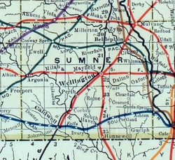
1915 Railroad Map of Sumner County
Map of Sumner Co, Ks, USA.png
USA Kansas location map.svg
Red pog.svg
Rome
Usa edcp location map.svg
Red pog.svg
Rome
Coordinates: 37°9′37″N97°23′29″W / 37.16028°N 97.39139°W / 37.16028; -97.39139 [1]
Country United States
State Kansas
County Sumner
Elevation
[1]
1,211 ft (369 m)
Time zone UTC-6 (CST)
  Summer (DST) UTC-5 (CDT)
Area code 620
FIPS code 20-61000
GNIS ID 470318 [1]

Rome is an unincorporated community in Sumner County, Kansas, United States. [1] It is located approximately 6.5 miles south of Wellington and about 0.5 mile east of the intersection of U.S. Route 81 and E 90th St, adjacent to the railroad. [1]

Contents

History

A post office was opened in Rome in 1874, and remained in operation until it was discontinued in 1933. [2]

Economy

Rome has a Farmers Co-Op Grain business with the capability to load grain into rail cars.

Education

The community is served by Wellington USD 353 public school district. [3]

References

  1. 1 2 3 4 5 "Rome, Kansas", Geographic Names Information System , United States Geological Survey, United States Department of the Interior
  2. "Kansas Post Offices, 1828-1961, page 2". Kansas Historical Society. Retrieved March 10, 2020.
  3. "USD 353 District Map" (PDF). Kansas Department of Transportation. Archived (PDF) from the original on February 29, 2020.

Further reading