Ewell, Kansas

Last updated

KDOT map of Sumner County (legend) Map of Sumner Co, Ks, USA.png
KDOT map of Sumner County (legend)
1915 Railroad Map of Sumner County Stouffer's Railroad Map of Kansas 1915-1918 Sumner County.png
1915 Railroad Map of Sumner County

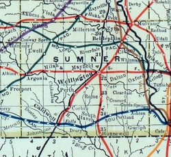
Ewell is a ghost town in Sumner County, Kansas, United States. [1] It is located about 3.5 miles southwest of Conway Springs at 0.25 mile southeast of the intersection of N Bluff Rd and W 60th Ave N, next to an abandoned railroad. [2]

Contents

History

Ewell was located next to a former railroad between Conway Springs and Argonia.

Ewell had a post office between 1885 and 1906. [3]

This community no longer exists, though a modern home and its buildings exist on the site.

Education

The rural area around the former community is currently served by Conway Springs USD 356 public school district.

Related Research Articles

<span class="mw-page-title-main">Sumner County, Kansas</span> County in Kansas, United States

Sumner County is a county located in the U.S. state of Kansas. Its county seat is Wellington. As of the 2020 census, the population was 22,382. The county is named after Charles Sumner, a U.S. Senator from Massachusetts who was a leader of Reconstruction politics.

<span class="mw-page-title-main">Morris County, Kansas</span> County in Kansas, United States

Morris County is a county located in the U.S. state of Kansas. Its county seat and largest city is Council Grove. As of the 2020 census, the county population was 5,386. The county was named for Thomas Morris, a U.S. Senator from Ohio and anti-slavery advocate.

<span class="mw-page-title-main">McPherson County, Kansas</span> County in Kansas, United States

McPherson County is a county located in the U.S. state of Kansas. Its county seat and largest city is McPherson. As of the 2020 census, the county population was 30,223. The county was named for James McPherson, a general in the American Civil War.

<span class="mw-page-title-main">Viola, Kansas</span> City in Sedgwick County, Kansas

Viola is a city in Sedgwick County, Kansas, United States. As of the 2020 census, the population of the city was 115.

<span class="mw-page-title-main">Sumner, Missouri</span> City in Missouri, United States

Sumner is a city in Chariton County, Missouri, United States. The population was 78 at the 2020 census. It was named in honor of U.S. Senator Charles Sumner.

<span class="mw-page-title-main">Haslet, Texas</span> City in Texas, United States

Haslet is a city in mostly Tarrant County and partly in Denton County within the Dallas–Fort Worth metroplex in the U.S. state of Texas, and is located 15 miles north of downtown Fort Worth and 20 miles south of Denton. Haslet borders Interstate 35W, U.S. Highway 287, and Alliance Airport.

<span class="mw-page-title-main">Corbin, Kansas</span> Unincorporated community in Sumner County, Kansas

Corbin is an unincorporated community in Sumner County, Kansas, United States. It is located about 6.5 miles northeast of Caldwell near the intersection of S Mayfield Rd and W 110th St S, next to the railroad.

<span class="mw-page-title-main">Milton, Kansas</span> Unincorporated community in Sumner County, Kansas

Milton is an unincorporated community in Sumner County, Kansas, United States. As of the 2020 census, the population of the community and nearby areas was 155. It is located 4.5 miles (7.2 km) southeast of Norwich at the intersection of N Argonia Rd and W 120th Ave N, next to the railroad.

<span class="mw-page-title-main">Brainerd, Kansas</span> Unincorporated community in Butler County, Kansas

Brainerd is an unincorporated community in Butler County, Kansas, United States. It is located on the north side of K-196 highway between the cities of Whitewater and Potwin.

<span class="mw-page-title-main">Furley, Kansas</span> Unincorporated community in Sedgwick County, Kansas

Furley is an unincorporated community in Sedgwick County, Kansas, United States. As of the 2020 census, the population of the community and nearby areas was 39. It is located northwest of the intersection of Greenwich Road and 101st Street N, along the Union Pacific Railroad.

<span class="mw-page-title-main">Ashton, Kansas</span> Unincorporated community in Sumner County, Kansas

Ashton is an unincorporated community in Walton Township, Sumner County, Kansas, United States. It is located about halfway between South Haven and Arkansas City at 1.75 miles north of the intersection of S Rock Rd and U.S. Route 166, which is 5.5 miles east of I-35, next to an abandoned railroad.

Bayneville is an unincorporated community in Ohio Township, Sedgwick County, Kansas, United States. It is located on S 87th W between W 71st S and W 79st S.

<span class="mw-page-title-main">Drury, Kansas</span> Unincorporated community in Sumner County, Kansas

Drury is an unincorporated community in Falls Township, Sumner County, Kansas, United States. It is located between South Haven and Caldwell near the intersection of S Drury Rd and W 175th St S, next to the Chikaskia River and next to an abandoned railroad.

<span class="mw-page-title-main">Adamsville, Kansas</span> Unincorporated community in Sumner County, Kansas

Adamsville is an unincorporated community in Sumner County, Kansas, United States. It is located about 4 miles north of Geuda Springs at 0.5 mile west of the intersection of S Oxford Rd and E 80th St, next to an abandoned railroad.

<span class="mw-page-title-main">Anson, Kansas</span> Unincorporated community in Sumner County, Kansas

Anson is an unincorporated community in Sumner County, Kansas, United States. It is located about 6 miles east of Conway Springs at 1.5 miles south of the intersection of N Anson Rd and W 90th St N, next to an abandoned railroad. It currently contains a small number of homes, but no businesses or services.

<span class="mw-page-title-main">Cicero, Kansas</span> Unincorporated community in Sumner County, Kansas

Cicero is an unincorporated community in Sumner County, Kansas, United States. It is located about 4 miles northeast of Wellington at about 2.5 miles east of the intersection of U.S. Route 81 and E 50th Ave N, next to the railroad.

<span class="mw-page-title-main">Millerton, Kansas</span> Unincorporated community in Sumner County, Kansas

Millerton is an unincorporated community in Sumner County, Kansas, United States. It is located about 5 miles northeast of Conway Springs at the intersection of N Maple Rd and W 123rd Ave N, next to the railroad.

<span class="mw-page-title-main">Portland, Kansas</span> Unincorporated community in Sumner County, Kansas

Portland is an unincorporated community in Sumner County, Kansas, United States. It is located about 5 miles northeast of South Haven at 1.5 miles north of the intersection of S Hydraulic Rd and U.S. Route 166, next to an abandoned railroad. It is 1.5 miles east of I-35.

<span class="mw-page-title-main">Riverdale, Kansas</span> Unincorporated community in Sumner County, Kansas

Riverdale is an unincorporated community in Sumner County, Kansas, United States. It is located about 6 miles southwest of Belle Plaine at the intersection of N Sand Plum Rd and 77th Ave N, or west of U.S. Route 81 next to the railroad.

<span class="mw-page-title-main">Comiskey, Kansas</span> Ghost town in Morris County, Kansas

Comiskey is a ghost town in Morris County, Kansas, United States. It was located approximately 6 miles (9.7 km) east of Council Grove, next to the county line.

References

  1. "Ewell, Kansas", Geographic Names Information System , United States Geological Survey, United States Department of the Interior
  2. Blackmar, Frank Wilson (1912). Kansas: A Cyclopedia of State History, Embracing Events, Institutions, Industries, Counties, Cities, Towns, Prominent Persons, Etc. Standard Publishing Company. pp.  601.
  3. "Kansas Post Offices, 1828-1961". Kansas Historical Society. Archived from the original on October 9, 2013. Retrieved June 27, 2014.

Further reading

37°20′24″N97°41′26″W / 37.34000°N 97.69056°W / 37.34000; -97.69056