Corbin is an unincorporated community in Sumner County, Kansas, United States.[1] It is located about 6.5 miles northeast of Caldwell near the intersection of S Mayfield Rd and W 110th St S, next to the railroad.
The community is served by Caldwell USD 360 public school district.
Transportation
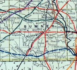
The Chicago, Rock Island and Pacific Railroad formerly provided passenger rail service to Corbin on their mainline from Minneapolis to Houston until at least 1951.[4] As of 2025, the nearest passenger rail station is located in Newton, where Amtrak's Southwest Chief stops once daily on a route from Chicago to Los Angeles.[5]
This page is based on this Wikipedia article Text is available under the CC BY-SA 4.0 license; additional terms may apply. Images, videos and audio are available under their respective licenses.