
Texas County is a county located in the panhandle of the U.S. state of Oklahoma. Its county seat is Guymon. As of the 2020 census, the population was 21,384. It is the second largest county in Oklahoma, based on land area, and is named for Texas, the state that adjoins the county to its south. Texas County comprises the Guymon, OK Micropolitan Statistical Area. The county economy is largely based on farming and cattle production. It is one of the top-producing counties in the U.S. for wheat, cattle, and hogs. It also lies within the noted Hugoton-Panhandle natural gas field.

Winfield is a city and county seat of Cowley County, Kansas, United States. It is situated along the Walnut River in South Central Kansas. As of the 2020 census, the population of the city was 11,777. It is home to Southwestern College.

Lee's Summit is a city in the U.S. state of Missouri and is a suburb in the Kansas City metropolitan area. It straddles Jackson (predominantly) and Cass counties. As of the 2020 census, its population was 101,108, making it the sixth-largest city in both Missouri and the Kansas City metropolitan area.

Hy-Vee Arena, previously known as Kemper Arena, is an indoor arena located in Kansas City, Missouri. Prior to conversion to a youth sports and community gymnasium facility, Kemper Arena was previously a 19,500-seat professional sports arena. It has hosted NCAA Final Four basketball games, professional basketball and hockey teams, professional wrestling events, the 1976 Republican National Convention, concerts, and is the ongoing host of the American Royal livestock show.

Hackney is an unincorporated community in Cowley County, Kansas, United States.
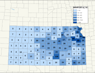
There are over 1,400 buildings, sites, districts, and objects in Kansas listed on the National Register of Historic Places in Kansas. NRHP listings appear in 101 of the state's 105 counties.
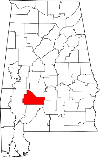
This is a list of the National Register of Historic Places listings in Wilcox County, Alabama.

The Harrisburg Giants were a U.S. professional Negro league baseball team based in Harrisburg, Pennsylvania. Originally formed in April 1890 by Colonel William "C.W." Strothers as an amateur team, they became semi-professional by 1894. They joined the Eastern Colored League (ECL) for the 1924 season with Hall of Fame center fielder Oscar Charleston as playing manager. The Giants became known primarily for their hitting; along with Charleston, outfielder/first baseman Heavy Johnson, winner of the batting triple crown for the 1923 Kansas City Monarchs, was signed away from the rival Negro National League. Speedy outfielder Fats Jenkins, a well-known professional basketball player and member of the New York Rens, also played for Harrisburg throughout its tenure in the ECL.
Strother Field is a public airport in Cowley County, Kansas, six miles southwest of Winfield and north of Arkansas City. The airport is jointly owned by the two cities. The National Plan of Integrated Airport Systems for 2011–2015 categorized it as a general aviation facility.

This is a list of the National Register of Historic Places listings in Wood County, Ohio.

This is a list of the National Register of Historic Places listings in Atchison County, Kansas.
This is a list of the National Register of Historic Places listings in Russell County, Kansas.

The following outline is provided as an overview of and topical guide to the U.S. state of Kansas:

Fort Strother was a stockade fort at Ten Islands in the Mississippi Territory, in what is today St. Clair County, Alabama. It was located on a bluff of the Coosa River, near the modern Neely Henry Dam in Ragland, Alabama. The fort was built by General Andrew Jackson and several thousand militiamen in November 1813, during the Creek War and was named for Captain John Strother, Jackson's chief cartographer.
Green Hill Cemetery Historic District is a national historic district located at Martinsburg, Berkeley County, West Virginia. The 15-acre (6.1 ha) site encompasses two contributing buildings, one contributing site, and 22 contributing objects. The rural cemetery was designed in 1854 by David Hunter Strother modeled on a French cemetery. It includes a Neoclassical Revival style mausoleum (1917–1918) and a Shingle Style caretaker's lodge (1901). The cemetery includes a number of notable monuments, as well as the graves of Strother and his family.

The National Register of Historic Places listings in downtown Kansas City, Missouri is intended to be a complete list of the properties and districts on the National Register of Historic Places in downtown Kansas City, Missouri, United States. Downtown Kansas City is defined as being roughly bounded by the Missouri River to the north, 31st Street to the south, Troost Avenue to the east, and State Line Road to the west. The locations of National Register properties and districts are in an online map.
This is a list of the National Register of Historic Places listings in Kansas City, Missouri outside downtown.

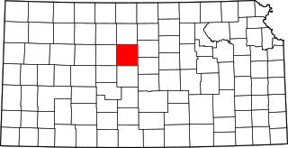
This is a list of the National Register of Historic Places listings in Ness County, Kansas. It is intended to be a complete list of the properties and districts on the National Register of Historic Places in Ness County, Kansas, United States. The locations of National Register properties and districts for which the latitude and longitude coordinates are included below, may be seen in an online map.
The Shulthis Stadium Grandstand was a baseball grandstand located in Independence, Kansas.
The Harper Standpipe is a standpipe built during 1886–87 in Harper, Kansas. It was listed on the National Register of Historic Places in 2017.

