Rice County is a county located in the U.S. state of Kansas. Its county seat and largest city is Lyons. As of the 2020 census, the county population was 9,427. The county was named in memory of Samuel Allen Rice, Brigadier-General, United States volunteers, killed April 30, 1864, at Jenkins Ferry, Arkansas.

Marion County is a county located in the U.S. state of Kansas. Its county seat is Marion and its most populous city is Hillsboro. As of the 2020 census, the county population was 11,823. The county was named in honor of Francis Marion, a brigadier general of the American Revolutionary War, known as the "Swamp Fox".

Chase County is a county located in the U.S. state of Kansas. Its county seat and most populous city is Cottonwood Falls. As of the 2020 census, the county population was 2,572. The county was named for Salmon Chase, a U.S. Senator from Ohio that was a Kansas statehood advocate.

Cedar Point is a city in Chase County, Kansas, United States. As of the 2020 census, the population of the city was 22. It is about 5 miles east of Florence and 0.5 miles south of U.S. Route 50 highway.
Cottonwood Falls is the largest city and county seat of Chase County, Kansas, United States. As of the 2020 census, the population of the city was 851. It is located south of Strong City along the south side of the Cottonwood River.

Elmdale is a city in Chase County, Kansas, United States. As of the 2020 census, the population of the city was 40. It is located along U.S. Route 50 highway.

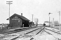
Strong City is a city in Chase County, Kansas, United States. Originally known as Cottonwood Station, in 1881 it was renamed Strong City after William Barstow Strong, then vice-president and general manager, and later president of the Atchison, Topeka and Santa Fe Railway. As of the 2020 census, the population of the city was 386. It is located along U.S. Route 50 highway.

Walton is a city in Harvey County, Kansas, United States. It is named in honor of one of the 19th century stockholders of Atchison, Topeka and Santa Fe Railway. As of the 2020 census, the population of the city was 219.

Durham is a city in Marion County, Kansas, United States. As of the 2020 census, the population of the city was 89. The city took its name from Durham cattle. It is located about 8.5 miles (14 km) north of Hillsboro on the west side of K-15 highway next to a railroad.

Florence is a city in Marion County, Kansas, United States. As of the 2020 census, the population of the city was 394. The city was named after the daughter of the third Governor of Kansas Samuel J. Crawford. It is located at the intersection of U.S. Route 50 and U.S. Route 77 highways.

Lost Springs is a city in Marion County, Kansas, United States. As of the 2020 census, the population of the city was 55. The city was named for a nearby lost spring that was a camping spot along the 19th century Santa Fe Trail. It is located south of Herington, about 0.6 miles west of the intersection of U.S. Route 77 highway and 340th Street next to the Union Pacific Railroad.
Marion is a city in, and the county seat of, Marion County, Kansas, United States. As of the 2020 census, the population of the city was 1,922. The city was named in honor of Francis Marion, a brigadier general of the American Revolutionary War, known as the "Swamp Fox".
Huscher is an unincorporated community in Cloud County, Kansas, United States.
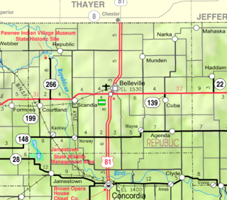
Kackley is an unincorporated community in Republic County, Kansas, United States. It is located southeast of Courtland at Co Rd 5 and K-148 highway.
Dahinda is an unincorporated community in Knox County, Illinois, United States. It is part of the Galesburg Micropolitan Statistical Area. Dahinda is in Persifer Township and lies approximately one mile north of U.S. Highway 150 and Interstate 74. Knox County Highway 15 runs from north to south through Dahinda. Once a bustling town, as time has gone on, the businesses in this community moved on, but the community still continues to exist.

Burdick is an unincorporated community in Morris County, Kansas, United States. It was named after Ms. Burdick, the sweetheart of a Santa Fe Railroad official in 1887. As of the 2020 census, the population of the community and nearby areas was 62. It is located southeast of Herington, about 5.6 miles (9.0 km) east of the intersection of U.S. Route 77 highway and 340th Street, or about 6.5 miles (10.5 km) east of Lost Springs.

Canada is an unincorporated community in Marion County, Kansas, United States. It is named for many Canadian immigrants coming to the area. It is located between Hillsboro and Marion about 0.5 miles south of the intersection of Nighthawk Road and U.S. Route 56 highway, southwest of the Hillsboro Cove of the Marion Reservoir.
Clements is an unincorporated community in Chase County, Kansas, United States. It is located about halfway between Strong City and Florence near the intersection of U.S. Route 50 highway and G Rd.

De Graff is an unincorporated community in Butler County, Kansas, United States. It is located on U.S. Route 77 approximately 7.7 miles (12.4 km) north of I-35
Jacob Safford was a justice of the Kansas Supreme Court from January 9, 1865, to January 9, 1871.