Toledo, Kansas | |
|---|---|
 | |
 Toledo  Toledo | |
| Country | United States |
| State | Kansas |
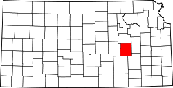
| County | Chase |
| Elevation | 1,171 ft (357 m) |
| Time zone | UTC-6 (CST) |
| • Summer (DST) | UTC-5 (CDT) |
| Area code | 620 |
| FIPS code | 20-70765 [1] |
| GNIS ID | 477280 [1] |
Toledo is an unincorporated community in Chase County, Kansas, United States. [1] It is located approximately seven miles west of Emporia at the intersection of Yy and 240 Roads (about one mile north of U.S. Route 50).