Noble County, Oklahoma

Last updated

Noble County
NobleCountyCourthousPerry.jpg
Map of Oklahoma highlighting Noble County.svg
Location within the U.S. state of Oklahoma
Oklahoma in United States.svg
Oklahoma's location within the U.S.
Coordinates: 36°23′N97°14′W / 36.39°N 97.24°W / 36.39; -97.24
CountryFlag of the United States.svg United States
StateFlag of Oklahoma.svg  Oklahoma
Founded1893
Named for John Willock Noble
Seat Perry
Largest cityPerry
Area
  Total743 sq mi (1,920 km2)
  Land732 sq mi (1,900 km2)
  Water11 sq mi (30 km2)  1.4%%
Population
 (2020)
  Total10,924
  Density15/sq mi (5.7/km2)
Congressional district 3rd
Website www.noblecountyok.com

Noble County is located in the north central part of Oklahoma. As of the 2020 census, the population was 10,924. [1] Its county seat is Perry. [2] It was part of the Cherokee Outlet in Indian Territory until Oklahoma Territory was created in 1890, and the present county land was designated as County P. After the U. S. government opened the area to non-Indian settlement in 1893, it was renamed Noble County for John Willock Noble, then the United States Secretary of the Interior. [3]

Contents

History

During the 18th and 19th centuries, the area now occupied by Noble County was used as a hunting ground by the Osage Indians. In 1835, a treaty with the Cherokees made it part of the so-called Cherokee Outlet. During the time of Cherokee ownership, non-native cattlemen who belonged to the Cherokee Strip Live Stock Association leased grazing land from the tribe. Later, reservations were created in the northeastern part of the county for the Otoe and Ponca tribes. These reservations existed until 1904, when the lands were allotted and added to Noble County. [3]

The Cherokee Outlet became part of Oklahoma Territory at the time of the Oklahoma Organic Act, and was divided into counties. After the 1893 opening of the Cherokee Outlet for settlement by non-Indians, the land was divided into counties. One county, originally designated as County P, was renamed in honor of John W. Noble, interior secretary in 1893. The town of Perry was laid out in August 1893 as the county seat and land-office town [3]

Oklahoma City bomber Timothy McVeigh was arrested in Noble County April 19, 1995 heading north bound on Interstate 35. McVeigh was stopped for not having a car tag on his car. He was minutes from being released when the Noble County Sheriff's Department was notified to hold McVeigh. McVeigh was tried and convicted for the bombing attack that killed 168 persons and injured many more. He was executed in 2001. McVeigh's arresting officer, Charlie Hanger, was elected Noble County Sheriff in 2004. [4] [5]

In 2010, the Keystone-Cushing Pipeline (Phase II) was constructed north to south through Noble County.
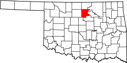
Geography

According to the U.S. Census Bureau, the county has a total area of 743 square miles (1,920 km2), of which 732 square miles (1,900 km2) is land and 11 square miles (28 km2) (1.4%) is water. [6] The Arkansas River forms part of the county's northeastern boundary. Two of its tributaries, Red Rock Creek in the north and by Black Bear Creek in the south, drain the county before emptying into the Arkansas River. [3]

Major highways

Adjacent counties

Demographics

Historical population
CensusPop.Note
1900 11,798
1910 14,94526.7%
1920 13,560−9.3%
1930 15,13911.6%
1940 14,826−2.1%
1950 12,156−18.0%
1960 10,376−14.6%
1970 10,043−3.2%
1980 11,57315.2%
1990 11,045−4.6%
2000 11,4113.3%
2010 11,5611.3%
2020 10,924−5.5%
U.S. Decennial Census [7]
1790-1960 [8] 1900-1990 [9]
1990-2000 [10] 2010 [11]

As of the census [12] of 2000, there were 11,411 people, 4,504 households, and 3,211 families residing in the county. The population density was 6/km2 (16/sq mi). There were 5,082 housing units at an average density of 3/km2 (7.8/sq mi). The racial makeup of the county was 86.44% White, 1.58% Black or African American, 7.57% Native American, 0.33% Asian, 0.03% Pacific Islander, 0.65% from other races, and 3.40% from two or more races. 1.80% of the population were Hispanic or Latino of any race.

There were 4,504 households, out of which 32.00% had children under the age of 18 living with them, 59.00% were married couples living together, 8.40% had a female householder with no husband present, and 28.70% were non-families. 25.50% of all households were made up of individuals, and 11.20% had someone living alone who was 65 years of age or older. The average household size was 2.47 and the average family size was 2.97.

In the county, the population was spread out, with 25.50% under the age of 18, 7.90% from 18 to 24, 27.50% from 25 to 44, 23.90% from 45 to 64, and 15.20% who were 65 years of age or older. The median age was 38 years. For every 100 females there were 97.40 males. For every 100 females age 18 and over, there were 96.00 males.

The median income for a household in the county was $33,968, and the median income for a family was $40,180. Males had a median income of $32,224 versus $21,235 for females. The per capita income for the county was $17,022. About 9.60% of families and 12.80% of the population were below the poverty line, including 16.40% of those under age 18 and 11.00% of those age 65 or over.
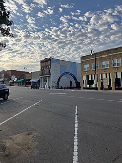
Politics

Noble County is reliably Republican. In only five elections since 1912 (out of 28) has the Democratic nominee carried the county, and no Democrat carried it after 1964.

Voter Registration and Party Enrollment as of January 15, 2019 [13]
PartyNumber of VotersPercentage
Democratic 1,85528.94%
Republican 3,84159.93%
Others71311.12%
Total6,409100%
United States presidential election results for Noble County, Oklahoma [14]
Year Republican Democratic Third party
No.%No.%No.%
2020 3,82177.38%1,00320.31%1142.31%
2016 3,71576.16%90118.47%2625.37%
2012 3,48875.32%1,14324.68%00.00%
2008 3,88176.78%1,17423.22%00.00%
2004 3,99374.94%1,33525.06%00.00%
2000 3,23068.77%1,41630.15%511.09%
1996 2,31848.38%1,75636.65%71714.97%
1992 2,47446.83%1,33325.23%1,47627.94%
1988 3,01563.80%1,66135.15%501.06%
1984 4,01876.11%1,23823.45%230.44%
1980 3,66369.90%1,39826.68%1793.42%
1976 2,63453.05%2,27845.88%531.07%
1972 4,08578.38%99919.17%1282.46%
1968 2,91158.92%1,41228.58%61812.51%
1964 2,15744.29%2,71355.71%00.00%
1960 3,19862.61%1,91037.39%00.00%
1956 3,53663.68%2,01736.32%00.00%
1952 4,42271.04%1,80328.96%00.00%
1948 2,43046.73%2,77053.27%00.00%
1944 3,06056.95%2,30042.81%130.24%
1940 3,44151.56%3,22648.34%70.10%
1936 2,46138.60%3,90161.19%130.20%
1932 1,63527.03%4,41472.97%00.00%
1928 3,60766.21%1,77732.62%641.17%
1924 2,68051.15%1,92736.77%63312.08%
1920 2,46759.69%1,51536.66%1513.65%
1916 1,24344.03%1,34647.68%2348.29%
1912 1,26646.15%1,18843.31%28910.54%

Economy

The county economy has largely been based on agriculture and cattle. Wheat was the major crop, although alfalfa, oats, corn, and barley have also been important. The county lies in the Mid-Continent oil and gas region. Natural gas wells began producing in 1915–1919. Oil production began in the 1920s. [3]

Ditch Witch, a Charles Machine Works company, is headquartered in Perry, the county seat.

Communities

City

Towns

Census-designated place

Other unincorporated places

NRHP sites

The following sites in Noble County are listed on the National Register of Historic Places:

Related Research Articles

<span class="mw-page-title-main">Woods County, Oklahoma</span> County in Oklahoma, United States

Woods County is a county located in the northwestern part of the U.S. state of Oklahoma. As of the 2020 census, the population was 8,624. Its county seat is Alva. The county is named after Samuel Newitt Wood, a renowned Kansas populist.

<span class="mw-page-title-main">Pawnee County, Oklahoma</span> County in Oklahoma, United States

Pawnee County is a county located in the U.S. state of Oklahoma. As of the 2020 census, the population was 15,553. Its county seat is Pawnee. The county is named after the Pawnee Nation, whose reservation used to encompass the county prior to allotment in 1893.

<span class="mw-page-title-main">Kay County, Oklahoma</span> County in Oklahoma, United States

Kay County is a county located in the U.S. state of Oklahoma. As of the 2020 census, its population was 43,700. Its county seat is Newkirk, and the largest city is Ponca City.

<span class="mw-page-title-main">Harper County, Oklahoma</span> County in Oklahoma, United States

Harper County is a county located in the U.S. state of Oklahoma. As of the 2020 census, the population was 3,272, making it the third-least populous county in Oklahoma. The county seat is Buffalo. It was created in 1907 from the northwestern part of Woodward County, and named for Oscar Green Harper, who was clerk of the Oklahoma Constitutional Convention.

<span class="mw-page-title-main">Grant County, Oklahoma</span> County in Oklahoma, United States

Grant County is a county located on the northern border of the U.S. state of Oklahoma. As of the 2020 census, the population was 4,169. Its county seat is Medford. Originally designated as part of the Cherokee Outlet, it was named County L in Oklahoma Territory at the time of its opening to non-Indian settlement. A county election renamed it for U.S. President Ulysses S. Grant.

<span class="mw-page-title-main">Garfield County, Oklahoma</span> County in Oklahoma, United States

Garfield County is a county located in the U.S. state of Oklahoma. As of the 2020 census, the population was 62,846. Enid is the county seat and largest city within Garfield County. The county is named after President James A. Garfield.

<span class="mw-page-title-main">Otoe County, Nebraska</span> County in Nebraska, United States

Otoe County is a county in the U.S. state of Nebraska. As of the 2020 United States Census, the population was 15,912. Its county seat is Nebraska City. The county was formed in 1854, and was named tor the Otoe Indian tribe.

<span class="mw-page-title-main">Carrier, Oklahoma</span> Town in Oklahoma, United States

Carrier is a town in Garfield County, Oklahoma, United States. The population was 85 at the 2010 census.

<span class="mw-page-title-main">Fairmont, Oklahoma</span> Town in Oklahoma, United States

Fairmont is a town in Garfield County, Oklahoma, United States. The population was 134 at the 2010 census, a decrease from 147 at the 2000 census.

<span class="mw-page-title-main">Garber, Oklahoma</span> City in Oklahoma, United States

Garber is a city in Garfield County, Oklahoma, United States. The population was 822 at the 2010 census. The city is named after Martin Garber, father of Milton C. Garber, former U.S. congressman, Enid mayor, newspaper editor, and judge. The land was previously part of the Cherokee Outlet, until the U.S. government declared it open to non-Indian settlement in 1893.

<span class="mw-page-title-main">Medford, Oklahoma</span> City in Oklahoma, United States

Medford is a city in and the county seat of Grant County, Oklahoma, United States. As of the 2010 census, the city population was 996.

<span class="mw-page-title-main">Renfrow, Oklahoma</span> Town in Oklahoma, United States

Renfrow is a town in Grant County, Oklahoma, United States. The population was 12 at the 2010 census, a decline of 33.3 percent from the figure of 16 at the 2000 census.

<span class="mw-page-title-main">Kildare, Oklahoma</span> Town in Oklahoma, United States

Kildare is a town in Kay County, Oklahoma, United States. The population was 100 at the 2010 census, an 8.7 percent increase from the figure of 92 in 2000.

<span class="mw-page-title-main">Newkirk, Oklahoma</span> City in Oklahoma, United States

Newkirk is a city and county seat of Kay County, Oklahoma, United States. The population was 2,172 at the 2020 census.

<span class="mw-page-title-main">Orlando, Oklahoma</span> Town in Oklahoma, United States

Orlando is a town in Logan and Payne counties in the U.S. state of Oklahoma. The population was 148 at the 2010 census, compared to the figure of 201 in 2000. It is part of the Oklahoma City Metropolitan Statistical Area.

<span class="mw-page-title-main">Billings, Oklahoma</span> Town in Oklahoma, United States

Billings is a town in northwest Noble County, Oklahoma, United States. The population was 509 at the 2010 census, an increase from the figure of 436 in 2000. It was the childhood home of Oklahoma governor Henry Bellmon.

<span class="mw-page-title-main">Morrison, Oklahoma</span> Town in Oklahoma, United States

Morrison is a town in southeastern Noble County, Oklahoma, United States. The population was 733 at the 2010 census, an increase from the figure of 636 in 2000.

<span class="mw-page-title-main">Perry, Oklahoma</span> City in Oklahoma, United States

Perry is a city in, and county seat of, Noble County, Oklahoma, United States. As of the 2010 census, the city population was 5,126, a 2.0 percent decrease from the figure of 5,230 in 2000. The city is home of Ditch Witch construction equipment.

<span class="mw-page-title-main">Red Rock, Oklahoma</span> Town in Oklahoma, United States

Red Rock is a town in northern Noble County, Oklahoma, United States. The population was 283 at the 2010 census, a decline from 293 at the 2000 census. The headquarters of the Otoe-Missouria Tribe of Indians is located in Red Rock.

<span class="mw-page-title-main">Pawnee, Oklahoma</span> City in Oklahoma, United States

Pawnee is a city and county seat of Pawnee County, Oklahoma, United States. The town is northeast of Stillwater at the junction of U.S. Route 64 and State Highway 18.

References

  1. "Noble County, Oklahoma". United States Census Bureau . Retrieved May 20, 2023.
  2. "Find a County". National Association of Counties. Archived from the original on May 31, 2011. Retrieved June 7, 2011.
  3. 1 2 3 4 5 Dianna Everett, "Noble County." Encyclopedia of Oklahoma History and Culture. Retrieved October 3, 2013.
  4. "Search results for Oklahoma Trooper Reflects on McVeigh Arrest in Art…". www.officer.com. Archived from the original on September 9, 2012. Retrieved June 6, 2022.
  5. "Oklahoma Sheriffs Association". www.oklahomasheriffs.com. Archived from the original on May 10, 2009.
  6. "2010 Census Gazetteer Files". United States Census Bureau. August 22, 2012. Retrieved February 21, 2015.
  7. "U.S. Decennial Census". Census.gov. United States Census Bureau. Retrieved February 21, 2015.
  8. "Historical Census Browser". University of Virginia Library. Retrieved February 21, 2015.
  9. Forstall, Richard L., ed. (March 27, 1995). "Population of Counties by Decennial Census: 1900 to 1990". United States Census Bureau. Retrieved February 21, 2015.
  10. "Census 2000 PHC-T-4. Ranking Tables for Counties: 1990 and 2000" (PDF). United States Census Bureau. April 2, 2001. Archived (PDF) from the original on October 9, 2022. Retrieved February 21, 2015.
  11. "State & County QuickFacts". United States Census Bureau. Archived from the original on June 6, 2011. Retrieved November 12, 2013.
  12. "U.S. Census website". United States Census Bureau . Retrieved January 31, 2008.
  13. "Oklahoma Registration Statistics by County" (PDF). OK.gov. January 15, 2019. Archived from the original (PDF) on July 17, 2020. Retrieved February 27, 2019.
  14. Leip, David. "Dave Leip's Atlas of U.S. Presidential Elections". uselectionatlas.org. Retrieved March 29, 2018.

36°23′N97°14′W / 36.39°N 97.24°W / 36.39; -97.24