Sumner, Oklahoma | |
|---|---|
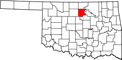
 Sumner, Oklahoma Location within the state of Oklahoma  Sumner, Oklahoma Sumner, Oklahoma (the United States) | |
| Coordinates: 36°19′8″N97°7′17″W / 36.31889°N 97.12139°W | |
| Country | United States |
| State | Oklahoma |
| County | Noble |
| Area | |
• Total | 0.15 sq mi (0.38 km2) |
| • Land | 0.15 sq mi (0.38 km2) |
| • Water | 0 sq mi (0.00 km2) |
| Elevation | 938 ft (286 m) |
| Population (2020) | |
• Total | 35 |
| • Density | 240.5/sq mi (92.87/km2) |
| Time zone | UTC-6 (Central (CST)) |
| • Summer (DST) | UTC-5 (CDT) |
| FIPS code | 40-71500 |
| GNIS feature ID | 2812860 [2] |
Sumner is an unincorporated community and census-designated place [2] located in Noble County, Oklahoma, United States, ten miles east of Perry and two miles north of U.S. Route 64. Established prior to statehood along the St. Louis-San Francisco Railway, the post office opened on May 23, 1894. The town was named for Henry T. Sumner, a businessman from Perry. Per the 1905 Oklahoma Territorial Census, Sumner had sixty-four residents. The post office closed July 27, 1957.
The town currently has a population of approximately fifty. At its peak the town had a bank, post office, two churches, a school, a grain elevator, and a train stop. Currently, the only significant buildings still in use are the Baptist church, the Christian church and the school.