Perry, Oklahoma

Last updated

Perry, Oklahoma
Downtown Perry, Oklahoma.jpg
Downtown Perry
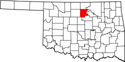
OKMap-doton-Perry.PNG
Location within Noble County and Oklahoma
Coordinates: 36°17′01″N97°18′34″W / 36.28361°N 97.30944°W / 36.28361; -97.30944 [1]
Country United States
State Oklahoma
County Noble
Government
  TypeAldermanic
Area
[2]
  Total55.0009 sq mi (20.14 km2)
  Land6.82 sq mi (17.66 km2)
  Water0.96 sq mi (2.48 km2)
Elevation
[1]
1,060 ft (320 m)
Population
 (2020)
  Total4,484
  Density657.77/sq mi (253.95/km2)
Time zone UTC-6 (Central (CST))
  Summer (DST) UTC-5 (CDT)
ZIP code
73077
Area code 580
FIPS code 40-58250
GNIS feature ID2411404 [1]
Website Perry, Oklahoma

Perry is a city in, and county seat of, Noble County, Oklahoma, United States. [1] As of the 2010 census, the city population was 5,126, a 2.0 percent decrease from the figure of 5,230 in 2000. [3] The city is home of Ditch Witch construction equipment manufacture.

Contents

History

19th century

The Treaty of New Echota, May 23, 1836, assigned the Cherokee Outlet to the Cherokees as a perpetual outlet to use for passage to travel and hunt in the West from their reservation in the eastern part of what became Oklahoma. This was in addition to the land given to the Cherokees for settlement after their arrival from their home in Georgia.

Sunrise in Perry (2007) Sunrise in Perry Oklahoma.jpg
Sunrise in Perry (2007)

Perry's original name was Wharton, the name of a train station built in 1886 by the Southern Kansas Railway (part of the Atchison, Topeka and Santa Fe Railway system) about 1 mile south of the present city and it was located within the Outlet. Before the 1893 Cherokee Outlet Opening, the U.S. government selected a site a mile north of Wharton for a land office. A town around the office was named after J.A. Perry, a man sent by the government to lay out land office towns. [4] Perry later became one of the township location commissioners. Noble County, then known as "County P", was named after John Willock Noble of St. Louis, the Interior Secretary for President William Henry Harrison. [5]

The Dalton Gang, which at that time included Bob Dalton, Emmett Dalton, Charlie Bryant and George Newcomb entered Wharton to rob a train in May 1891 earning $1745. Shortly after the robbery, Bryant fell ill and was taken to Hennessey to see a doctor. After being spotted and arrested by Deputy Marshal Ed Short. During an escape attempt Bryant and Short would kill each other. [6] Among those within the boundary of the Strip prior to the opening, were the notorious Bill Doolin gang. A Santa Fe train was robbed at Wharton before the opening, and the gang escaped into Osage County. U.S. Marshall E.D. Nix and 100 deputies were commissioned to police the area and keep order. [5]

At noon on September 16, 1893, "a run" for land within "the Strip" was opened. An estimated 90,000 men, women, and children took part and by nightfall 40,000 had erected tents in Perry. Jack Tearney started at the county line and reached Perry within 31 minutes. By 4:00 p.m. he had erected and opened the "Blue Bell" saloon selling beer the first day for $1.00 a bottle, due to the scarcity of water. He would sell 38,000 glasses. [5]

Named "Hell's Half Acre", the original town's perimeter included A & F streets and 1st and 9th streets. About 110 saloons and gambling houses were in operation with many of them set up 1/2 block east of the west side of the now existing square. [5]

Perry incorporated on September 20, 1893. [4]

20th century

In 1902, Carl Malzahn, a German immigrant, moved to Perry and opened the Malzahn Blacksmith Shop with his sons, Charles (Charlie) and Gus. The sons took over the business in 1913 and renamed it Malzahn Brothers' General Blacksmithing, specializing in repairing equipment for the nearby oil fields. After Gus died in 1928, the surviving brother renamed the business, Charlie’s Machine Shop. Charlie's son, Ed, a mechanical engineer, joined the business in 1944. Ed noticed a need for a machine to replace hand digging trenches for the installation of residential utility lines, and set to work developing such a device. By 1948, he had a successful device, a compact trencher, which he called the Ditch Witch. Soon, Ditch Witch became a successful company, wholly owned by the now-renamed Charles Machine Works Company, since 2019 a subsidiary of The Toro Company. It has grown into the largest employer in Perry and in Noble County, employing approximately 1,300 people. [7]

Timothy McVeigh was stopped on April 19, 1995, along Interstate 35 outside of Perry by Oklahoma Highway Patrol Trooper Charlie Hanger. Trooper Hanger had passed McVeigh's yellow 1977 Mercury Marquis and noticed it had no license plate. He arrested McVeigh for carrying a loaded firearm. Three days later, while still in jail, McVeigh was identified as the subject of a nationwide manhunt for the perpetrator of the Oklahoma City bombing, which had happened on the day of McVeigh's arrest. [8] [9]

21st century

Perry moved from a strong mayor form of government to a Home Rule Charter. The town is in the process of transitioning to a City Manager. [ citation needed ]

Operating under the Home Rule Charter form of government, the City of Perry divides its responsibilities between the city council and the city manager. The city council acts as the legislative branch, establishing ordinances, setting policy, authorizing budgets, and directing the city manager when appropriate. The city manager oversees day-to- day operations and administration of the city. Together with city staff, the city manager and city council work to make the most efficient use of the limited resources available to the City of Perry. [10]

It is the smallest town in Oklahoma with a daily newspaper. [5]

Geography

Perry is 60 miles (97 km) north of Oklahoma City, [4] and 100 miles (160 km) south of Wichita, Kansas.

According to the United States Census Bureau, the city has a total area of 6.8 square miles (18 km2), of which 6.1 square miles (16 km2) is land and 0.8 square miles (2.1 km2) (10.98%) is water.

Demographics

Historical population
CensusPop.Note
1900 3,351
1910 3,133−6.5%
1920 3,1540.7%
1930 4,20633.4%
1940 5,04519.9%
1950 5,1371.8%
1960 5,2101.4%
1970 5,3412.5%
1980 5,7968.5%
1990 4,978−14.1%
2000 5,2305.1%
2010 5,126−2.0%
2020 4,484−12.5%
U.S. Decennial Census

As of the census [11] of 2000, there were 5,230 people, 2,203 households, and 1,445 families residing in the city. The population density was 860.1 inhabitants per square mile (332.1/km2). There were 2,493 housing units at an average density of 410.0 per square mile (158.3/km2). The racial makeup of the city was 89.7% White, 3.1% African American, 3.3% Native American, 0.5% Asian, 0.1% Pacific Islander, 0.6% from other races, and 2.7% from two or more races. Hispanic or Latino of any race were 1.8% of the population. [12]

There were 2,203 households, out of which 29.4% had children under the age of 18 living with them, 52.6% were married couples living together, 9.0% had a female householder with no husband present, and 34.4% were non-families. 30.6% of all households were made up of individuals, and 14.6% had someone living alone who was 65 years of age or older. The average household size was 2.31 and the average family size was 2.88.

In the city, the population was spread out, with 24.0% under the age of 18, 8.9% from 18 to 24, 27.2% from 25 to 44, 21.6% from 45 to 64, and 18.4% who were 65 years of age or older. The median age was 38 years. For every 100 females, there were 92.4 males. For every 100 females age 18 and over, there were 90.5 males.

The median income for a household in the city was $30,653, and the median income for a family was $37,731. Males had a median income of $30,485 versus $22,039 for females. The per capita income for the city was $16,924. About 10.4% of families and 14.0% of the population were below the poverty line, including 16.2% of those under age 18 and 11.0% of those age 65 or over.

Economy

The city is home to Charles Machine Works, which is the headquarters and manufacturing facility of Ditch Witch machinery and employs over 1,300 people. [7] In November 2022, the company announced an expansion adding over 200,000 square feet to the Ditch Witch campus together with 100 new jobs. [13]

Education

Perry High School is noted for its wrestling program, historically one of the most successful programs in the United States; it has won 63 state championships, including 43 team and 20 dual championships since 1952, and 163 individual state championships. [14]

The Wrestling Monument Park in Perry The Wrestling Monument Park in Perry.jpg
The Wrestling Monument Park in Perry

Perry is also home to one of the many Carnegie Libraries in the United States.

The Carnegie Library in Perry The Carnegie Library in Perry, OK.jpg
The Carnegie Library in Perry

Government

The city of Perry has been governed under a Home Rule City Charter Form of Government since the motion passed by popular vote and was approved by the Governor in 2008.

The Perry Police Department consists of 12 full time police officers, five dispatchers and an animal control officer. The Chief of Police is Brian Thomas.

The Perry Fire Department consists of nine full time firefighters.

Historic Sites

Multiple historic sites in Perry are NRHP-listed:

A memorial in Perry One of the Veterans' Memorials in Noble County, OK.jpg
A memorial in Perry

Parks and Recreation

The Cherokee Strip Museum is operated by the Oklahoma Historical Society. It provides an opportunity to explore the remarkable events and people constituting the history of the Cherokee Outlet. The facility includes The Rose Hill School, giving fourth-grade students an opportunity to experience an education from yesteryear; and, a Blacksmith Shop, allowing visitors to see what crafting tools was like in pioneer days. [15]

Since 2016, Perry has operated the Perry BMAC Baseball Complex, complete with four ball fields, each equipped with a digital scoreboard and control system. The complex includes covered bleachers and a full concessions area. [16]

Perry Lake is two miles off US-77. The lake was originally created to be the primary water source for the City of Perry; however, its primary use is now recreational. The lake offers boating, skiing, swimming, fishing, and RV camping. [17]

CCC Lake and Park, created in 1934 by the Civilian Conservation Corps (CCC) as part of the New Deal, is just to the south of Perry on SH-86. The lake itself is now Perry’s primary water source; so, while swimming and fishing are allowed, only trolling motors are permitted on the lake. Three pavilions are available for use, as is Centennial Church, a beautiful 1894 building moved to the Park and fully renovated by 2007. All these facilities can be reserved for special occasions. [17]

Lake McMurtry is to the southeast; and, Lake Carl Blackwell is to the south. [18]

Notable people

See also

Related Research Articles

<span class="mw-page-title-main">Woodward County, Oklahoma</span> County in Oklahoma, United States

Woodward County is a county located in the U.S. state of Oklahoma. As of the 2020 census, the population was 20,470. Its county seat is Woodward.

<span class="mw-page-title-main">Washington County, Oklahoma</span> County in Oklahoma, United States

Washington County is a county located in the northeastern part of the U.S. state of Oklahoma. As of the 2020 census, the population was 52,455. Its county seat is Bartlesville. Named for President George Washington, it is the smallest county in Oklahoma in total area, adjacent to the largest county in Oklahoma, Osage County. Washington County comprises the Bartlesville, OK micropolitan statistical area, which is also included in the Tulsa-Muskogee-Bartlesville, OK combined statistical area. It is located along the border with Kansas.

<span class="mw-page-title-main">Pawnee County, Oklahoma</span> County in Oklahoma, United States

Pawnee County is a county located in the U.S. state of Oklahoma. As of the 2020 census, the population was 15,553. Its county seat is Pawnee. The county is named after the Pawnee Nation, whose reservation used to encompass the county prior to allotment in 1893.

<span class="mw-page-title-main">Noble County, Oklahoma</span> County in Oklahoma, United States

Noble County is a county located in the north central part of Oklahoma. As of the 2020 census, the population was 10,924. Its county seat is Perry. It was part of the Cherokee Outlet in Indian Territory until Oklahoma Territory was created in 1890, and the present county land was designated as County P. After the U. S. government opened the area to non-Indian settlement in 1893, it was renamed Noble County for John Willock Noble, then the United States Secretary of the Interior.

<span class="mw-page-title-main">Kay County, Oklahoma</span> County in Oklahoma, United States

Kay County is a county located in the U.S. state of Oklahoma. As of the 2020 census, its population was 43,700. Its county seat is Newkirk, and the largest city is Ponca City.

<span class="mw-page-title-main">Grant County, Oklahoma</span> County in Oklahoma, United States

Grant County is a county located on the northern border of the U.S. state of Oklahoma. As of the 2020 census, the population was 4,169. Its county seat is Medford. Originally designated as part of the Cherokee Outlet, it was named County L in Oklahoma Territory at the time of its opening to non-Indian settlement. A county election renamed it for U.S. President Ulysses S. Grant.

<span class="mw-page-title-main">Garfield County, Oklahoma</span> County in Oklahoma, United States

Garfield County is a county located in the U.S. state of Oklahoma. As of the 2020 census, the population was 62,846. Enid is the county seat and largest city within Garfield County. The county is named after President James A. Garfield. Garfield County comprises the Enid, OK metropolitan statistical area.

<span class="mw-page-title-main">Delaware County, Oklahoma</span> County in Oklahoma, United States

Delaware County is a county located in the U.S. state of Oklahoma. As of the 2020 census, the population was 40,397. Its county seat is Jay. The county was named for the Delaware Indians, who had established a village in the area prior to the Cherokees being assigned to relocate to Indian Territory in the 1830s. Delaware County was created in 1907. Prior to becoming Delaware County, a large portion of the area was known as the Delaware District of the Cherokee Nation. Today, Delaware County continues to be recognized by the Cherokee Nation as the Delaware District.

<span class="mw-page-title-main">Cherokee, Oklahoma</span> City in Oklahoma, United States

Cherokee is the largest city within, and county seat of, Alfalfa County, Oklahoma, United States. The population was 1,476 at the 2020 census, a decline of 1.5 percent from 2010.

<span class="mw-page-title-main">Jay, Oklahoma</span> City in Oklahoma, United States

Jay is a city and county seat of Delaware County, Oklahoma, United States. The population was 2,448 at the 2010 census, compared to 2,482 at the 2000 census, a decrease of 1.4 percent. Almost 40% of its residents are Native American, thus Jay is home to numerous Cherokee tribal offices and a health clinic for the Delaware District of the Cherokee Nation. Jay has a council-manager system of government. Becki Farley is the mayor with Kyle Stump serving as Vice Mayor.

<span class="mw-page-title-main">Stigler, Oklahoma</span> City in Oklahoma, United States

Stigler is a city in and county seat of Haskell County, Oklahoma. The population was 2,685 at the time of the 2010 census, down from 2,731 recorded in 2000.

<span class="mw-page-title-main">Newkirk, Oklahoma</span> City in Oklahoma, United States

Newkirk is a city in and the county seat of Kay County, Oklahoma, United States. The population was 2,172 at the 2020 census.

<span class="mw-page-title-main">Chandler, Oklahoma</span> City in Oklahoma, United States

Chandler is a city in, and the county seat of, Lincoln County, Oklahoma, United States. and is part of the Oklahoma City Metropolitan Area. The population was 2,858 at the time of the 2020 census. Chandler is located northeast of Oklahoma City on SH-66 and I-44, and north of Shawnee on SH-18.

<span class="mw-page-title-main">Orlando, Oklahoma</span> Town in Oklahoma, United States

Orlando is a town in Logan and Payne counties in the U.S. state of Oklahoma. The population was 148 at the 2010 census, compared to the figure of 201 in 2000. It is part of the Oklahoma City Metropolitan Statistical Area.

<span class="mw-page-title-main">Locust Grove, Oklahoma</span> Town in the United States

Locust Grove is a town in Mayes County, Oklahoma, United States. The population was 1,423 at the 2010 census, a 4.2 percent increase over the figure of 1,366 recorded in 2000.

<span class="mw-page-title-main">Morrison, Oklahoma</span> Town in Oklahoma, United States

Morrison is a town in southeastern Noble County, Oklahoma, United States. The population was 733 at the 2010 census, an increase from the figure of 636 in 2000.

<span class="mw-page-title-main">Okemah, Oklahoma</span> City in Oklahoma, United States

Okemah is the largest city in and the county seat of Okfuskee County, Oklahoma, United States. It is the birthplace of folk music legend Woody Guthrie. Thlopthlocco Tribal Town, a federally recognized Muscogee Indian tribe, is headquartered in Okemah. The population was 3,078 at the 2020 census, a 6.1 percent decline from 3,223 at the 2010 census.

<span class="mw-page-title-main">Cleveland, Oklahoma</span> City in Oklahoma, United States

Cleveland is a city in Pawnee County, Oklahoma, United States. The population was 3,205 as of the 2020 Census.

<span class="mw-page-title-main">Ditch Witch</span> Brand of trencher machines

Ditch Witch, a trade name of Charles Machine Works, is an American brand of underground utility construction equipment, principally trenchers, which has been in operation since 1949. It is the leading subsidiary of Charles Machine Works, headquartered in Perry, Oklahoma. Charles Machine Works is, since 2019, a subsidiary of Toro Company.

<span class="mw-page-title-main">Perry Courthouse Square Historic District</span> Historic district in Oklahoma, United States

The Perry Courthouse Square Historic District in Perry, Oklahoma, derives its name from the presence of the Noble County Courthouse, built in 1915. It contains the majority of the commercial development of the original Perry townsite. The district contains 132 buildings,, 92 contributing resources, and 37 noncontributing resources. Its period of significance is given as 1893 to 1953. The period begins with the Land Run of 1893.The District was added to the National Register of Historic Places under Criteria A and C on September 2, 2003. The NRIS reference number is 03000881.

References

  1. 1 2 3 4 U.S. Geological Survey Geographic Names Information System: Perry, Oklahoma
  2. "ArcGIS REST Services Directory". United States Census Bureau. Retrieved September 20, 2022.
  3. "2010 City Population and Housing Occupancy Status". U.S. Census Bureau. Archived from the original on April 11, 2015. Retrieved April 14, 2011.
  4. 1 2 3 Mildred Highfill, "Perry." Encyclopedia of Oklahoma History and Culture. Accessed October 21, 2013.
  5. 1 2 3 4 5 Fred R. Belk. "EARLY HISTORY OF PERRY, OKLAHOMA". Archived from the original on February 20, 2001. Retrieved March 6, 2011.
  6. gunslinger.com. "The Dalton Gang". gunslinger.com. Archived from the original on July 19, 2011. Retrieved March 6, 2011.
  7. 1 2 Hannemann, Carolyn G. "Ditch Witch." Encyclopedia of Oklahoma History and Culture. Accessed November 17, 2016.
  8. Arrest of Timothy McVeigh
  9. Noble County Information
  10. "City of Perry Oklahoma - Government". www.cityofperryok.com. Retrieved April 1, 2019.
  11. "U.S. Census website". United States Census Bureau . Retrieved January 31, 2008.
  12. "Perry city, Oklahoma - Fact Sheet - American FactFinder". Archived from the original on February 12, 2020. Retrieved May 3, 2010.
  13. "Ditch Witch expands operations in Oklahoma town". KOCO Oklahoma City, November 17, 2022 (accessed on MSN.com). Retrieved November 18, 2022.
  14. John Klein, "Perry's tradition in wrestling is unmatched", Tulsa World . June 30, 2012 (pay site).
  15. "Cherokee Strip Museum". City of Perry. Retrieved June 8, 2020.
  16. "BMAC Complex". City of Perry. Retrieved June 8, 2020.
  17. 1 2 "Perry Lake, and CCC Lake and Park". City of Perry. Retrieved June 8, 2020.
  18. "Carl Blackwell Lake". Google Maps. Retrieved June 8, 2020.
  19. O'Dell, Larry. Encyclopedia of Oklahoma History and Culture. "Galbreath Robert (1863 - 1953)." Retrieved May 12, 2014.