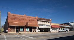
Marietta, Oklahoma | |
---|---|
Motto: "Gateway To Lake Country" | |
Coordinates: 33°56′08″N97°07′29″W / 33.93556°N 97.12472°W | |
Country | United States |
State | Oklahoma |
County | Love |
Area | |
• Total | 2.59 sq mi (6.71 km2) |
• Land | 2.58 sq mi (6.69 km2) |
• Water | 0.01 sq mi (0.02 km2) |
Elevation | 837 ft (255 m) |
Population (2020) | |
• Total | 2,719 |
• Density | 1,053.06/sq mi (406.53/km2) |
Time zone | UTC-6 (Central (CST)) |
• Summer (DST) | UTC-5 (CDT) |
ZIP code | 73448 |
Area code | 580 |
FIPS code | 40-46500 [3] |
GNIS feature ID | 2411034 [2] |
Website | www |
Marietta is a city and county seat in Love County, Oklahoma, United States. [4] The population was 2,719 as of the 2020 Census, [5] a 3.5% increase over the 2,626 reported at the 2010 census, which itself was a 7.4 percent increase from the figure of 2,445 in 2000. [6] Marietta is part of the Ardmore, Oklahoma, Micropolitan Statistical Area. For tourism purposes, the Oklahoma Department of Tourism includes it in 'Chickasaw Country'. It is also a part of the Texoma region.
Settlers were attracted by the fertile land near the Red River, which was conducive to agriculture and cattle raising. Cotton quickly became the principal crop. William "Bill" Washington had the largest cattle ranch in Pickens County, Chickasaw Nation, Indian Territory. Bill's brother, Jeremiah Calvin Washington (Jerry), who lived about a mile north of present-day Marietta on the Washington Ranch which has a historical marker and is lived in by a Washington descendant's extended family, became the town's first postmaster when the post office opened on December 20, 1887. He was a banker and gentleman rancher. A local story claims that the town was named for Jerry's wife, Marietta Love Washington. [7]
At the time of its founding, Marietta was located in Pickens County, Chickasaw Nation. [8]
The Gulf, Colorado and Santa Fe Railway (later the Atchison, Topeka and Santa Fe Railway) laid its rail line in early 1887, stimulating economic growth for the future town of Marietta, Indian Territory. The first train ran July 28, 1887. [7]
Marietta had 1,391 settlers at the time of Oklahoma Statehood in 1907. The Love County Courthouse, one of four sites in the town listed on the NRHP, was the first built after statehood in Oklahoma and was completed in 1910. There were 1,546 residents in the 1910 census, and the town was served by at least three banks, three churches and 24 retail establishments. [7]
The northwestern part of town was hit by a violent EF4 tornado on April 27, 2024. A large Dollar Tree metal distribution warehouse was shredded with part of the structure collapsing and the next door Homeland was partially blown out when a large wall collapsed. One person was killed on I-35. [9] [10]
Marietta is 15 miles (24 km) north of the Red River and 114 miles (183 km) south of Oklahoma City. [7] According to the United States Census Bureau, the city has a total area of 2.4 square miles (6.2 km2), of which 2.4 square miles (6.2 km2) is land and 0.42% is water.
Census | Pop. | Note | %± |
---|---|---|---|
1900 | 842 | — | |
1910 | 1,546 | 83.6% | |
1920 | 1,977 | 27.9% | |
1930 | 1,505 | −23.9% | |
1940 | 1,837 | 22.1% | |
1950 | 1,875 | 2.1% | |
1960 | 1,933 | 3.1% | |
1970 | 2,013 | 4.1% | |
1980 | 2,494 | 23.9% | |
1990 | 2,306 | −7.5% | |
2000 | 2,445 | 6.0% | |
2010 | 2,626 | 7.4% | |
2020 | 2,719 | 3.5% | |
U.S. Decennial Census |
As of the 2010 United States Census, there were 2,626 people, 983 households, and 670 families residing in the city. The population density was 1,029.2 inhabitants per square mile (397.4/km2). There were 1,115 housing units at an average density of 461 per square mile (178/km2). The racial makeup of the city was 64.4% white, 4.7% African American, 5.8% Native American, 0.7% Asian, 18.5% from other races, and 5.9% from two or more races. Hispanic or Latino of any race were 25.9% of the population.
There were 983 households, out of which 34.2% had children under the age of 18 living with them, 44.5% were married couples living together, 17.7% had a female householder with no husband present, and 31.8% were non-families. Twenty-eight percent of households were made up of individuals, and 2.3% of the population was institutionalized. The average household size was 2.6 and the average family size was 3.7.
In the city, the population was spread out, with 28.7% under the age of 18, 8.9% from 18 to 24, 26.1% from 25 to 44, 21.2% from 45 to 64, and 15.1% who were 65 years of age or older. The median age was 33.7 years. For every 100 females, there were 87.7 males. For every 100 females age 18 and over, there were 97.1 males.
The median income for a household in the city was $33,198, and the median income for a family was $37,188. Males had a median income of $28,900 versus $25,556 for females. The per capita income for the city was $13,625. About 20% of families and 26% of the population were below the poverty line.
Downtown Marietta suffered when Interstate 35 was built on the edge of town. By the turn of the 21st Century, the main employers were the Marietta Bakery (400 workers) and Siemens Dematic (65 workers). In January 2004, the bakery declared bankruptcy and closed. Soon after, the Siemens plant closed. Months later the Chickasaw Nation bought the Siemens plant and rehired many of the former employees. That facility now builds and repairs oil field equipment. [11] Still later, it bought the bakery and reopened it, though with a much smaller work force.
Marietta is located on State Highway 32 at the corner of junction U.S. Route 77 and is just east of Interstate 35.
Love County is a county on the southern border of the U.S. state of Oklahoma. As of the 2020 census, the population was 10,146. Its county seat is Marietta. The county was created at statehood in 1907 and named for Overton Love, a prominent Chickasaw farmer, entrepreneur and politician.
Beaver is a town and county seat in Beaver County, Oklahoma, United States. The community is in the Oklahoma Panhandle. As of the 2020 census, the town’s population was 1,280. The city is host to the annual World Cow Chip Throwing Championship. Held in April, "Cow Chip" brings attention from nearby cities with a parade, carnival, and cowchip throwing.
Kemp is a town in Bryan County, Oklahoma, United States. The population was 133 at the 2010 census, a decrease of 7.8 percent from the total of 144 recorded in 2000.
Bridgeport is a town in Caddo County, Oklahoma, United States. The population was 116 at the 2010 census.
Hinton is a town in Caddo County, Oklahoma, United States. The population was 3,196 as of the 2010 census, up from 2,175 in 2000. It is approximately 50 miles (80 km) west of Oklahoma City.
Gene Autry is a town in Carter County, Oklahoma, United States. The population was 154 at the time of the 2020 census, down just slightly from the 158 reported in the 2010 census. It is part of the Ardmore, Oklahoma Micropolitan Statistical Area.
Lindsay is a city in Garvin County, Oklahoma, United States. The population was 2,840 at the 2010 census. It once promoted itself as "The Broomcorn Capital of the World" but no longer uses that slogan, as broomcorn is no longer raised in the area.
Milburn is a town in Johnston County, Oklahoma, United States, along the Blue River. The population was 252 as of the 2020 Census. The town is notable as the location of the Chickasaw White House, the former home of Chickasaw Governor Douglas H. Johnston. This home is now a museum and is listed on the NRHP.
Tishomingo is the largest city in, and the county seat of, Johnston County, Oklahoma, United States. The population was 3,101 as of the 2020 Census,, an increase of 2.2% over the population of 3,034 reported at the 2010 census. It was the first capital of the Chickasaw Nation, from 1856 until Oklahoma statehood in 1907. The city is home to Murray State College, a community college with an annual enrollment of 3,015 students. Tishomingo is part of the Texoma region.
Braman is a town in Kay County, Oklahoma, United States. The population was 217 at the 2010 census, a decline of 11.1 percent from the figure of 244 in 2000.
Thackerville is a town in Love County, Oklahoma, United States. It is located near the Texas state border. The population was 400 at the 2020 census.
Madill is a city in and the county seat of Marshall County, Oklahoma, United States. It was named in honor of George Alexander Madill, an attorney for the St. Louis-San Francisco Railway. The population at the 2010 census was 3,770, an increase of 10.8 percent from 3,410 at the 2000 census. It is best known as the site of the annual National Sand Bass Festival. It is part of the Texoma region.
Sulphur is a city in and county seat of Murray County, Oklahoma, United States. The population was 5,065 at the 2020 census, a 2.8 percent gain over the figure of 4,929 in 2010. The area around Sulphur has been noted for its mineral springs, since well before the city was founded late in the 19th century. The city received its name from the presence of sulfur in the water.
Haskell is a city, as of March 2024, in Muskogee County, Oklahoma, United States. The population was 2,007 at the 2010 census, a gain of 13.7 percent over the figure of 1,765 recorded in 2000. Haskell was established in 1904 on the Midland Valley Railroad. It was named for town site developer Charles N. Haskell, who would become the first governor of the State of Oklahoma in 1907.
South Coffeyville is a town in Nowata County, Oklahoma, United States. As of the 2010 census, the town population was 785. The city of Coffeyville, Kansas is located approximately one mile north of the city, existing as a separate political entity.
Pawhuska is a city in and the county seat of Osage County, Oklahoma, United States. As of the 2020 census, the population of the city was 2,984. It was named after the 19th-century Osage chief, Paw-Hiu-Skah, which means "White Hair" in English. The Osage tribal government, which opened offices in Pawhuska in 1872 when its reservation was established in Indian Territory, continues to be based in Pawhuska.
Hooker is a city in Texas County, Oklahoma, United States. As of the 2020 census, the city’s population was 1,802. It is located approximately 20 miles northeast of Guymon on US Route 54 highway.
Davis is a city in Garvin and Murray counties in the U.S. state of Oklahoma. The population is 2,823 as of the 2020 census.
Burneyville is an unincorporated community and census-designated place (CDP) in Love County, Oklahoma, United States. The post office was established May 5, 1879. It was named for David C. Burney, father of Benjamin Crooks Burney, who had been Governor of the Chickasaw Nation from 1878 through 1880.
Love County Airport was a public-use airport located two nautical miles northwest of the central business district of Marietta, a city in Love County, Oklahoma, United States. It has since closed.