Related Research Articles

Marietta is a city and county seat in Love County, Oklahoma, United States. The population was 2,719 as of the 2020 Census, a 3.5% increase over the 2,626 reported at the 2010 census, which itself was a 7.4 percent increase from the figure of 2,445 in 2000. Marietta is part of the Ardmore, Oklahoma, Micropolitan Statistical Area. For tourism purposes, the Oklahoma Department of Tourism includes it in 'Chickasaw Country'. It is also a part of the Texoma region.

Dane County Regional Airport (DCRA), also known as Truax Field, is a civil-military airport located 6 nautical miles northeast of downtown Madison, Wisconsin. In the Federal Aviation Administration (FAA) National Plan of Integrated Airport Systems for 2023–2027, it is one of 2 airports in Wisconsin that is categorized as a small-hub primary commercial service facility; the other is Appleton International Airport. It is the second busiest of eight commercial airports in Wisconsin in terms of passengers served, after Milwaukee Mitchell International Airport.
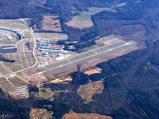
Atlanta Speedway Airport (formerly 4A7), is a public-use airport located three nautical miles (6 km) west of the central business district of Hampton, a city in Henry County, Georgia, United States. It was known as Clayton County Airport – Tara Field, which was the name still used by the Federal Aviation Administration (FAA) and the Georgia Department of Transportation (GDOT) until 2011. The airport was renamed Atlanta South Regional Airport, which was approved by the airport board of commissioners in December 2011, and was approved by the GDOT and the FAA before it went into effect. It was also known as Henry County Airport from 2013 to 2017.

South Arkansas Regional Airport at Goodwin Field is nine miles west of El Dorado, in Union County, Arkansas, United States. It was served by SeaPort Airlines, a service subsidized by the federal government's Essential Air Service program at a cost of $1,977,153. SeaPort Airlines ceased operations on September 20, 2016.

Rialto Municipal Airport, originally Miro Field, was a general aviation airport three miles (5 km) northwest of Rialto, in San Bernardino County, California, United States.
Broadus Airport is a county-owned, public-use airport located three miles (4.8 km) northwest of the central business district of Broadus, a town in Powder River County, Montana, United States. This new airport was built at a cost of $2 million to replace the old Broadus Airport which is now closed.
Williston Municipal Airport is a city-owned, public-use airport located two nautical miles (4 km) southwest of the central business district of Williston, a city in Levy County, Florida, United States. Commonly referred to as Williston Airport, it is located 23 miles (37 km) southwest of Gainesville Regional Airport (GNV). Opened in 1974 for public use, it does not have a control tower.
Goldfield Airport was a county-owned, public-use airport located 1 nautical mile north of the central business district of Goldfield, the county seat of Esmeralda County, Nevada, United States. The airport closed in 2007.
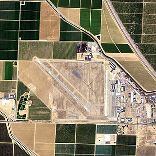
Shafter Airport, also known as Minter Field and formerly known as Air Corps Basic Flying School, is a public use airport located four nautical miles east of the central business district of Shafter and 14 miles northwest of Bakersfield, a city in Kern County, California, United States. Originally a World War II primary training facility for pilots, it is currently a public airport owned by the Minter Field Airport District. This airport is included in the National Plan of Integrated Airport Systems for 2011–2015, which categorized it as a general aviation facility.

Zelienople Municipal Airport is a public airport in Beaver County, Pennsylvania, a mile west of Zelienople, a borough in Butler County, Pennsylvania, in the Pittsburgh metropolitan area. The airport is owned by the Borough of Zelienople and operated by the Zelienople Municipal Authority. The National Plan of Integrated Airport Systems for 2011–2015 categorized it as a general aviation facility.
Skydive Houston Airport is a privately owned, private airport located in unincorporated Waller County, Texas, United States. It is four nautical miles (7 km) south of the central business district of Waller and is northwest of Houston. It was formerly known as Skylake Airport.

Langlade County Airport is a county-owned public-use airport located two nautical miles (4 km) northeast of the central business district of Antigo, a city in Langlade County, Wisconsin, United States. It is included in the Federal Aviation Administration (FAA) National Plan of Integrated Airport Systems for 2021–2025, in which it is categorized as a basic general aviation facility.
Cloquet Carlton County Airport is a county-owned public-use airport located three nautical miles (6 km) southwest of the central business district of Cloquet, a city in Carlton County, Minnesota, United States.
Henderson Aviation Airport is an airport located two nautical miles (4 km) northeast of the central business district of Felton, a town in Kent County, Delaware, United States. It is privately owned by Emad Albanna.
Owosso Community Airport is a public-use airport located in Caledonia Charter Township, two miles (3 km) east of Owosso, between the cities of Owosso and Corunna, in Shiawassee County, Michigan, United States. It is owned by the Shiawassee Airport Board, a multi-government authority with five voting members from Shiawassee County, the cities of Owosso and Corunna, and the townships of Owosso and Caledonia. It is included in the Federal Aviation Administration (FAA) National Plan of Integrated Airport Systems for 2017–2021, in which it is categorized as a local general aviation facility.
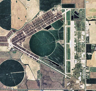
Pratt Regional Airport is a public airport five miles north of Pratt, in Pratt County, Kansas. Previously known as Pratt Industrial Airport, it is on the site of the former Pratt Army Airfield.
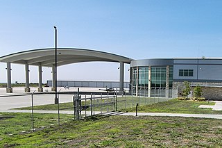
Austin Executive Airport is a public-use airport in Travis County, 14 miles northeast of Austin, immediately southeast of Pflugerville and north of Manor. It was known as Bird's Nest Airport until 2011.
McGehee Catfish Restaurant Airport is a privately owned, public-use airport located five nautical miles southwest of the central business district of Marietta, a city in Love County, Oklahoma, United States.
Davenport Airport, also known as Davenport Municipal Airport, is a city-owned, public-use airport located one nautical mile (2 km) west of the central business district of Davenport, a city in Lincoln County, Washington, United States. It is included in the National Plan of Integrated Airport Systems for 2011–2015, which categorized it as a general aviation facility.
Deerfield Valley Regional Airport was a privately owned, public use airport located one nautical mile (2 km) southwest of the central business district of West Dover, in Windham County, Vermont, United States.
References
- 1 2 3 "4O2 - Love County Airport - FAA information effective 7 July 2005". FAA data republished by AirNav. Archived from the original on 28 July 2005.
- ↑ "Love County Airport [CLOSED]". OurAirports.com. Retrieved June 27, 2024.