Pickens County was a political subdivision of the Chickasaw Nation in the Indian Territory from 1855, prior to Oklahoma being admitted as a state in 1907. The county was one of four that comprised the Chickasaw Nation. Following statehood, its territory was divided among several Oklahoma counties that have continued to the present.
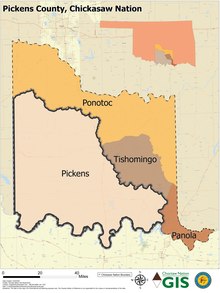
Map of Pickens County, Chickasaw Nation (1850-1907).
History
The Chickasaw Indians, after being removed from the southeastern United States to Indian Territory in the 1830s, were assigned to live within the boundaries of the Choctaw Nation. In 1855 the Chickasaw Nation was established as a separate entity. The boundaries and political subdivisions of the Chickasaw Nation may be traced to Choctaw laws and legislation.
Until the Chickasaws’ separation from the Choctaw Nation in 1855, the Choctaws divided their territory into four major administrative and judicial regions, or districts. Although the Chickasaw were free to live anywhere within the Choctaw Nation they chose, most were concentrated in its western region, known as the Chickasaw District.
In 1850 the Choctaw Nation approved a constitutional change that enabled each of its four constituent districts to be divided into counties. The Chickasaw District was divided into Panola County in the southeast, Wichita County in the southwest, Caddo County in the northwest, and Perry County in the northeast.[1] The precise date of Wichita County's creation is unclear, but it had assumed its name and functions by at least November 1851, according to judicial proceedings published by the Bryan County Heritage Association in 1977.[2] In 1854, the General Council of the Choctaw Nation changed the name of Wichita County to Pickens County.[3]
Pickens County was named for Edmund Pickens (Chickasaw), also known as Okchantubby, a leader who helped negotiate the 1854 agreement by which the Chickasaw separated from the Choctaw and established their own nation and territory. He also was integral to making the treaty of alliance with the Confederate States of America in 1861. Pickens was elected on Nov. 4, 1848 as the prospective Governor of the Chickasaw Nation during an early attempt to secede from the Choctaw Nation.[4]
Oakland, a community two miles northwest of Madill, was designated as the Pickens County seat.[5]
A constitution promulgated on Aug. 30, 1856 established the new Chickasaw government and its counties of Panola, Pickens, Pontotoc and Tishomingo. A Chickasaw Senate law on Oct. 5, 1859 set their boundaries definitively.[6]
The county government served mostly for judicial purposes. Voters elected the county judge and sheriff, who served two-year terms.[7] Constables, or deputies, assisted the sheriff in keeping public order. They were particularly needed in Pickens County, which covered a much larger geographic area than most counties.[8]
A federal law designed to prepare the Five Civilized Tribes for eventual statehood, known as the Curtis Act, stripped the Chickasaw and other governments of meaningful powers after 1906. During the period following the Act's passage in 1898, the Chickasaw government became, according to one historian, an “empty shell.” Although the Chickasaw constitution and laws were still in effect, all significant powers were transferred to the federal government.[9]
Geography
Pickens County lay in the southwestern part of the Chickasaw Nation between the Washita and Red rivers. The Washita River formed its eastern/northern boundaries, and its western boundary was the western edge of the Chickasaw Nation, also known as the 98th Meridian. Pickens County was unusually large and sprawling. It included the present-day cities of Ardmore, Duncan, Madill, Marietta, and Sulphur, extending almost as far as Chickasha.
Rush Creek, Wild Horse Creek, and Caddo Creek were the largest streams traversing the county.[10]
The county was defined by the Arbuckle Mountains, which formed a considerable barrier to movement and commerce in the center of the county.
Pickens County's location on the western edge of the domains of the Five Civilized Tribes left it exposed in its early years to external threats. Depredations and threats from the Kiowa, Comanche and Apache Indians, whose reservations lay to the west, caused the U.S. Army to bolster frontier defenses. A site on the Washita River was chosen in 1850 as the location of Fort Arbuckle. After the construction of Fort Sill to the west in 1869, Fort Arbuckle ceased to be strategically significant and was abandoned by the Army in 1870.
Despite its sprawl and size, a well-designed transportation network was never developed in the county, and trails linked the settlements. A stagecoach route ran east–west through the county, linking Fort Arbuckle with Fort Sill. Its western site was Rush Springs Stage Station. The Chisholm Trail ran through the western part of Pickens County, passing through the settlements of Fleetwood, Duncan Store (now Duncan), and Parr (southeast of present-day Rush Springs). It was first used by Indian hunting and raiding parties. After 1867, cattlemen driving livestock north adopted it, with their herds widening the trail. One railroad traversed the county: the Gulf, Colorado and Santa Fe Railroad, which passed north-to-south through Ardmore and Marietta.[10]
A singular point of geographic significance was established in Pickens County in 1870. General Land Office surveyors established Initial Point, or "point of beginning," at 34° 30' 24" N latitude and 97° 14' 49" W longitude. From this point all land in Indian Territory and Oklahoma Territory, and later the State of Oklahoma except for its Panhandle, would be surveyed and described. The site was west of Davis, Indian Territory (now Davis, Oklahoma). It is considered one of the notable initial points in the United States.[11]
Statehood
As Oklahoma's statehood approached, its leading citizens, who were gathered for the Oklahoma Constitutional Convention, realized in laying out the future state's counties that the Chickasaw Nation's counties were not designed to support the requirements of a modern state. Three of the four counties were unusually large and geographically sprawling, possibly due to the relatively sparse population living there. Pontotoc County, as example, spanned the countryside in a northwestern-to-southeastern arc from north of Chickasha to west of Wapanucka. Pickens County posed similar challenges, stretching from the Chickasha area in the northwest to Madill in the southeast. Following statehood the influx of settlers from the United States allowed for the region to be broken into smaller counties. But first the historic Chickasaw counties had to be disestablished.
This conundrum was recognized by the framers of the proposed State of Sequoyah, who met in 1905 to propose statehood for Indian Territory. The Sequoyah Constitutional Convention also proposed a county structure that abolished the Chickasaw counties. Pickens County was divided principally into the proposed counties of Bonaparte, Byrd, Curtis, Garvin, Gilbert, Guy, Harris, Jefferson, McLish, Overton, and Washington.[12]
Much of this proposition was borrowed two years later by Oklahoma's framers, who adopted certain of these concepts for the future counties of Carter, Garvin, Grady, Jefferson, Love, Marshall, Murray, and Stephens counties. Pickens County ceased to exist upon Oklahoma's statehood on November 16, 1907.
Related Research Articles
Marshall County is a county located on the south central border of Oklahoma. As of the 2020 census, the population was 15,312. Its county seat is Madill. The county was created at statehood in 1907 from the former Pickens County of the Chickasaw Nation. It was named to honor the maiden name of the mother of George Henshaw, a member of the 1906 Oklahoma Constitutional Convention. The county and its cities are part of the Texoma region.
Johnston County is a county located in the U.S. state of Oklahoma. As of the 2020 census, the population was 10,272. Its county seat is Tishomingo. It was established at statehood on November 16, 1907, and named for Douglas H. Johnston, a governor of the Chickasaw Nation.
Grady County is a county located in the U.S. state of Oklahoma. As of the 2020 census, the population was 54,795. Its county seat is Chickasha. It was named for Henry W. Grady, an editor of the Atlanta Constitution and southern orator.
The Washita River is a river in the states of Texas and Oklahoma in the United States. The river is 295 miles (475 km) long and terminates at its confluence with the Red River, which is now part of Lake Texoma on the Texas–Oklahoma border.
Fort Washita is the former United States military post and National Historic Landmark located in Durant, Oklahoma on SH 199. Established in 1842 by General Zachary Taylor to protect citizens of the Choctaw and Chickasaw Nations from the Plains Indians, it was later abandoned by Federal forces at the beginning of the American Civil War. Confederate troops held the post until the end of the war when they burned the remaining structures. It was never reoccupied by the United States military. After years in private hands the Oklahoma Historical Society bought the fort grounds in 1962 and restored the site. Today, the Fort Washita Historic Site and Museum is a tourist attraction and hosts several events throughout the year, and it is jointly managed by the Chickasaw Nation and the Oklahoma Historical Society.
The Sequoyah Constitutional Convention was an American Indian-led attempt to secure statehood for Indian Territory as an Indian-controlled jurisdiction, separate from the Oklahoma Territory. The proposed state was to be called the State of Sequoyah.
Jack's Fork County, also known as Jack Fork County, was a political subdivision of the Choctaw Nation of Indian Territory. The county formed part of the nation's Pushmataha District, or Third District, one of three administrative super-regions.
Jackson County was a political subdivision of the Choctaw Nation of Indian Territory, prior to Oklahoma being admitted as a state. The county formed part of the Nation's Pushmataha District, or Third District, one of three administrative super-regions.
Nashoba County was a political subdivision of the Choctaw Nation of Indian Territory. The county formed part of the Nation’s Apukshunnubbee District, or Second District, one of three administrative super-regions in the Nation. This territory was later made part of the state of Oklahoma.
Blue County was a political subdivision of the Choctaw Nation of Indian Territory, prior to Oklahoma being admitted as a state. The county formed part of the Nation’s Pushmataha District, or Third District, one of three administrative super-regions.
Atoka County was a political subdivision of the Choctaw Nation of Indian Territory, prior to Oklahoma being admitted as a state. The county formed part of the Nation's Pushmataha District, or Third District, one of three administrative and judicial provinces called districts.
Towson County was a political subdivision of the Choctaw Nation of Indian Territory, prior to Oklahoma being admitted as a state. The county formed part of the Nation's Apukshunnubbee a District, or Second District, one of three administrative super-regions.
Bok Tuklo County was a political subdivision of the Choctaw Nation of Indian Territory, prior to Oklahoma being admitted as a state. The county formed part of the Nation’s Apukshunnubbee District, or Second District, one of three administrative super-regions. The subdivision was located within the current McCurtain County.
Bok Tuklo County was a political subdivision of the Choctaw Nation of Indian Territory, prior to Oklahoma being admitted as a state. The county formed part of the Nation’s Apukshunnubbee District, or Second District, one of three administrative super-regions.
Skullyville County was a political subdivision of the Choctaw Nation of Indian Territory, prior to Oklahoma being admitted as a state. The county formed part of the Nation's Moshulatubbee District, or First District, one of three administrative super-regions.
Sans Bois County was a political subdivision of the Choctaw Nation of Indian Territory, prior to Oklahoma being admitted as a state. The county formed part of the Nation's Moshulatubbee District, or First District, one of three administrative super-regions.
Sugar Loaf County was a political subdivision of the Choctaw Nation of Indian Territory, prior to Oklahoma being admitted as a state. The county formed part of the Nation's Moshulatubbee District, or First District, one of three administrative super-regions.
Gaines County was a political subdivision of the Choctaw Nation of Indian Territory, prior to Oklahoma being admitted as a state. The county formed part of the Nation's Moshulatubbee District, or First District, one of three administrative super-regions.
Tobucksy County was a political subdivision of the Choctaw Nation of Indian Territory, prior to Oklahoma becoming a state. It was part of the Moshulatubbee District, or First District, one of three administrative super-regions.
References
↑ Arrell M. Gibson. The Chickasaws. Norman: University of Oklahoma Press, 1974. Page 241.
↑ For information see Chickasaw National Records: Picks and Wichita Counties, 1849-1881. Durant: Bryan County Heritage Association, 1977.
↑ Acts and Resolutions of the General Council of the Choctaw Nation, from 1852 to 1857, Both Inclusive, Fort Smith: Josephus Dodson, 1858, p. 73.
↑ Chronicles of Oklahoma, Vol. 8, No. 3 (1930), p. 328; George H. Shirk, Oklahoma Place Names (Norman: University of Oklahoma Press, 1974), P. 191; Gaston Litton, History of Oklahoma, New York: Lewis Historical Publishing Co., 1957, Vol. I, pp. 148-149.
↑ Thoburn, History of Oklahoma, p. 231; “Organization of Counties in the Choctaw and Chickasaw Nations,” Chronicles of Oklahoma, Vol. VIII (1930), pp. 327-328.
↑ Amos Maxwell, Sequoyah Constitutional Convention. Although the map carried in Wikipedia's article on the State of Sequoyah speaks to the matter of borders, Maxwell's book offers further insight.
This page is based on this Wikipedia article Text is available under the CC BY-SA 4.0 license; additional terms may apply. Images, videos and audio are available under their respective licenses.