Washita County is a county located in the U.S. state of Oklahoma. As of the 2020 census, the population was 10,924. Its county seat is New Cordell. The county seat was formerly located in Cloud Chief. The county was created in 1891.

Roger Mills County is a county located in the western part of the U.S. state of Oklahoma. As of the 2020 census, the population was 3,442, making it the fourth-least populous county in Oklahoma. Its county seat is Cheyenne. The county was created in 1891.

Johnston County is a county located in the U.S. state of Oklahoma. As of the 2020 census, the population was 10,272. Its county seat is Tishomingo. It was established at statehood on November 16, 1907, and named for Douglas H. Johnston, a governor of the Chickasaw Nation.

Bryan County is a county in the U.S. state of Oklahoma. As of the 2020 census, the population was 46,067. Its county seat is Durant. It is the only county in the United States named for Democratic politician William Jennings Bryan.
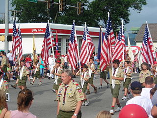
Scouting in Oklahoma has a long history, from the 1910s to the present day, serving thousands of youth in programs that suit the environment in which they live.

The Red River, or sometimes the Red River of the South to differentiate it from the Red River in the north of the continent, is a major river in the Southern United States. It was named for its reddish water color from passing through red-bed country in its watershed. It is known as the Red River of the South to distinguish it from the Red River of the North, which flows between Minnesota and North Dakota into the Canadian province of Manitoba. Although once a tributary of the Mississippi River, the Red River is now a tributary of the Atchafalaya River, a distributary of the Mississippi that flows separately into the Gulf of Mexico. This confluence is connected to the Mississippi River by the Old River Control Structure.

The Battle of the Washita River occurred on November 27, 1868, when Lt. Col. George Armstrong Custer's 7th U.S. Cavalry attacked Black Kettle's Southern Cheyenne camp on the Washita River.

Fort Cobb Reservoir is a reservoir located in Caddo County in the U.S. state of Oklahoma. It impounds the waters of Cobb Creek, Lake Creek, and Willow Creek. The lake covers approximately 4,000 acres (16 km2) of water and 45 mi (72 km) of shoreline. Its drainage area is 285 square miles (740 km2). It was constructed in 1958. The towns of Carnegie, Fort Cobb, and Eakly are located nearby.

Texoma is an interstate region in the United States, split between Oklahoma and Texas. The name is a portmanteau of Texas and Oklahoma. Businesses use the term in their names to describe their intended service area. This includes 8 counties with a population estimate of 319,455.

Choctaw Country is the Oklahoma Department of Tourism and Recreation's official tourism designation for Southeast Oklahoma. The name was previously Kiamichi Country until changed in honor of the Choctaw Nation headquartered there. The current definition of Choctaw Country includes ten counties, being Coal, Atoka, Bryan, Choctaw, McCurtain, Pushmataha, Le Flore, Latimer, Haskell, and Pittsburg counties. The department created the term as one of six designated travel regions within the state. However, other definitions of Southeastern Oklahoma may include additional counties.

South Central Oklahoma is an amorphous region in the state of Oklahoma, perhaps encompassing 10 counties. It is centered on the Arbuckle Mountains, an ancient, eroded range traversing some 70 miles (110 km) across the region, and surrounded by rivers and lakes, notably Lake Texoma, Lake Murray and Lake of the Arbuckles. For tourism purposes, the Oklahoma Department of Tourism has more narrowly defined South Central Oklahoma, which they refer to as Chickasaw Country, as being a seven-county region including Pontotoc, Johnston, Marshall, Garvin, Murray, Carter, and Love counties. A ten-county definition might also include Coal, Atoka, and Bryan counties, although the Department of Tourism includes those in Choctaw Country. The Choctaw Nation of Oklahoma covers the eastern third of the region. Its headquarters is in Durant, and its capitol building, now a museum, is in Tuskahoma. The Chickasaw Nation lies within the region, with the tribal capitol building located at Tishomingo and its headquarters in Ada. The Chickasaw Nation, which runs "Chickasawcountry.com"., promotes the idea of Chickasaw Country as the 13 south-central Oklahoma counties that comprise the Chickasaw Nation, being the Tourism Department’s seven counties plus Coal, Bryan, Jefferson, Stephens, Grady, and McClain counties.
Fort Washita is the former United States military post and National Historic Landmark located in Durant, Oklahoma on SH 199. Established in 1842 by General Zachary Taylor to protect citizens of the Choctaw and Chickasaw Nations from the Plains Indians, it was later abandoned by Federal forces at the beginning of the American Civil War. Confederate troops held the post until the end of the war when they burned the remaining structures. It was never reoccupied by the United States military. After years in private hands the Oklahoma Historical Society bought the fort grounds in 1962 and restored the site. In 2017, the Chickasaw Nation purchased Fort Washita from the Oklahoma Historical Society and assumed responsibility for the site and its management. Today, Fort Washita is a tourist attraction and hosts several events throughout the year. In August 2023, the Fort Washita Historic Site was placed into federal trust with the U.S. government.
The Sherman–Denison metropolitan statistical area, as defined by the United States Census Bureau, is an area consisting of one county—Grayson—in North Texas, anchored by the cities of Sherman and Denison. According to the 2010 U.S. census, the MSA had a population of 120,877; according to 2021 estimates, it had a population of 139,336. The Sherman–Denison MSA is a component of the Dallas-Ft. Worth combined statistical area, which covers a 19-county area and had an estimated population of 8,057,796 as of July 1, 2009. It is also a major part of the Texoma region with proximity to both Lake Texoma and the Red River.
Preston, also known as Preston Bend, is an unincorporated community and census-designated place located on the Red River in Grayson County, Texas, United States. It grew in the 19th century at the intersection of several military and trade roads and was an important crossing on the Shawnee cattle trail. Preston lost prominence after the MK&T railroad bypassed the town to the east, leading to a decline in traveler and cattle drive traffic. Much of its former town site is submerged beneath the waters of Lake Texoma. Its population was 2,096 as of the 2010 census.
Foss State Park is a 1,749-acre (708 ha) Oklahoma state park located on Foss Lake, in southwestern Custer County, Oklahoma, near the city of Foss.
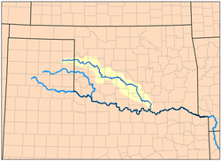
Muddy Boggy Creek, also known as the Muddy Boggy River, is a 175-mile-long (282 km) river in south central Oklahoma. The stream headwaters arise just east of Ada in Pontotoc County. It is a major tributary of the Red River in south central Oklahoma. Clear Boggy Creek is a major tributary which enters the Muddy Boggy at a location known as River Mile 24 in Choctaw County. The river is inhabited by over one hundred species of fish.
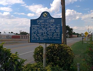
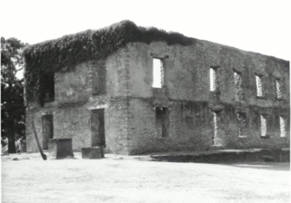
Fort Cobb was a United States Army post established in what is now Caddo County, Oklahoma in 1859 to protect relocated Native Americans from raids by the Comanche, Kiowa, and Cheyenne. The fort was abandoned by Maj. William H. Emory at the beginning of the Civil War, but then occupied by Confederate forces from 1861–1862. The post was eventually reoccupied by US forces starting in 1868. After establishing Fort Sill the US Army abandoned Fort Cobb. Today there is little left of the former military post.

The Black Kettle National Grassland, in Roger Mills County, Oklahoma, and Hemphill County, Texas, contains 31,286 acres (12,661 ha) of which 30,710 acres (12,430 ha) are in Oklahoma.