The land that is present-day Oklahoma was first settled by prehistoric American Indians including the Clovis 11500 BCE, Folsom 10600 BCE, and Plainview 10000 BCE cultures. Western explorers came to the region in the 16th century, with Spanish explorer Francisco Vásquez de Coronado visiting in 1541. Most of the region during this time was settled by the Wichita and Caddo peoples. Around the 1700s, two tribes from the north, the Comanche and Kiowa, migrated to the Oklahoma and Texas region.[6]
For most of the 18th century, the Oklahoma region was under French control as part of Louisiana. In 1803, the Louisiana Purchase by Thomas Jefferson brought the area under United States control. In 1830, Congress passed the Indian Removal Act, which removed American Indian tribes and relocated them to Indian Territory. The southern part of the territory was originally assigned to the Choctaw and Chickasaw, until the 1867 Medicine Lodge Treaty allotted the southwest portion of the Choctaw and Chickasaw's lands to the Comanche, Kiowa, and Apache.
The City of Walters was organized on August 6, 1901, under the original name of McKnight (named after the registrar at the Lawton land office), Indian Territory. Application for a post office was made, but a town in Harmon County was found to have already taken the name of McKnight. This required that the name be changed. Walter was chosen, in honor of either McKnight's son or for a prominent resident, William Walter(s). The post office was named Walter but Congress allowed it to be changed to Walters in 1917 .[7]
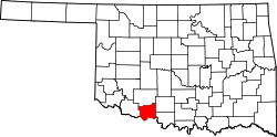
The city finally grew large enough to meet the requirements for a government patent, and one was granted in June 1904. On August 12, 1912, an election was held to form a new county (Cotton) from a portion of Comanche County. The election was successful, and Cotton County became the last county formed in Oklahoma, on August 28, 1912. Shortly thereafter, another election was held to determine whether Walters or Temple would become the county seat; on December 2, 1912, Walters won by 282 votes, officially becoming the seat of Cotton County. The names of Walter and Walters were used interchangeably and confusingly until June 1917, when an application was made to Congress to officially change the post office name to Walters.[7]
According to the United States Census Bureau, the city has a total area of 8.4 square miles (22km2), of which 0.2sqmi (0.52km2) (2.75%) is covered by water.
As of the 2000 census,[3] 2,657 people, 1,063 households, and 721 families resided in the city. The population density was 326.6 inhabitants per square mile (126.1/km2). The 1,256 housing units had an average density of 154.4 per square mile (59.6/km2). The racial makeup of the city was 84.38% White, 0.38% African American, 10.24% Native American, 0.08% Asian, 1.02% from other races, and 3.91% from two or more races. Hispanics or Latinos of any race were 3.42% of the population.
Of the 1,063 households, 33.6% had children under 18 living with them, 54.1% were married couples living together, 10.4% had a female householder with no husband present, and 32.1% were not families. About 30.1% of all households were made up of individuals, and 18.3% had someone living alone who was 65 or older. The average household size was 2.45 and the average family size was 3.05.
The city's age distribution was 27.8% under 18, 7.4% from 18 to 24, 26.7% from 25 to 44, 19.9% from 45 to 64, and 18.3% who were 65 or older. The median age was 37 years. For every 100 females, there were 87.0 males. For every 100 females 18 and over, there were 84.5 males.
The median income for a household in the city was $25,771, and for a family was $31,532. Males had a median income of $27,578 versus $18,669 for females. The per capita income for the city was $14,398. About 15.9% of families and 19.6% of the population were below the poverty line, including 25.4% of those under 18 and 17.9% of those 65 or over.
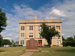
The Cotton County Courthouse, a Classical Revival structure, is from 1925.
The Walters Rock Island Depot: In 1984, the city bought the Rock Island Depot, and the Cotton County Art Council rehabilitated the building, turning it into a museum.[10]
Culture
The Walters Herald, the local newspaper published since 1925,[11] promotes itself as the "Voice of Cotton County".[12]
Walters has many annual festivals that take place throughout the year, centered around the arts, agriculture, Western cowboy culture, and Native American culture.
Spring
The CCAC Arts and Crafts Festival is a judged arts-and-crafts festival sponsored by the Cotton County Art Council and the Oklahoma Arts Council.[13]
Summer
Comanche Nation Homecoming Powwow features multiple categories of traditional American Indian dancing, including gourd, cloth, buckskin, straight, fancy and more. Food and merchandise vendors are also on hand.[14]
Round Up Club Rodeo, which besides the actual multiday rodeo, features a parade with decorated cars, trucks, tractors, and floats.[15]
This page is based on this Wikipedia article Text is available under the CC BY-SA 4.0 license; additional terms may apply. Images, videos and audio are available under their respective licenses.