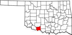
Taylor, Cotton County, Oklahoma

Last updated
Taylor
USA Oklahoma location map.svg
Red pog.svg
Taylor
Location within the state of Oklahoma
Usa edcp location map.svg
Red pog.svg
Taylor
Taylor (the United States)
Coordinates: 34°10′25″N98°19′52″W / 34.17361°N 98.33111°W / 34.17361; -98.33111
Country United States
State Oklahoma
County Cotton
Elevation
[1]
997 ft (304 m)
Time zone UTC-6 (Central (CST))
  Summer (DST) UTC-5 (CDT)
GNIS feature ID1100877 [1]

Taylor is an unincorporated community in Cotton County, Oklahoma, United States. [1] The elevation is 994 feet. [1] It was named after a local merchant, John Taylor. [2] The community had a post office from November 30, 1907 to May 31, 1911. [2]

Related Research Articles

<span class="mw-page-title-main">Greer County, Oklahoma</span> County in Oklahoma, United States

Greer County is a county located along the southwest border of the U.S. state of Oklahoma. As of the 2020 census, the population was 5,491. Its county seat is Mangum. From 1860 to 1896, the state of Texas claimed an area known as Greer County, Texas, which included present-day Greer County along with neighboring areas. In 1896 it was designated as a county in Oklahoma Territory under a ruling by the US Supreme Court. The rural Greer County is home to Quartz Mountain State Park, near the community of Lone Wolf, Oklahoma. It is also home to the Oklahoma State Reformatory, located in Granite. Its population has declined since 1930 due to changes in agriculture and migration to cities for work.

<span class="mw-page-title-main">Cotton County, Oklahoma</span> County in Oklahoma, United States

Cotton County is a county located in the U.S. state of Oklahoma. As of the 2020 census, the population was 5,527. Its county seat is Walters. When Oklahoma achieved statehood in 1907, the area which is now Cotton County fell within the boundaries of Comanche County. It was split off in 1912, becoming the last county created in Oklahoma; it was named for the county's primary crop.

<span class="mw-page-title-main">Tatums, Oklahoma</span> Town in Oklahoma, United States

Tatums is a historic Freedmen's town in Carter County, Oklahoma, United States. The population was 151 at the 2010 census, a decline of 12.2 percent from the figure of 172 in 2000. It is part of the Ardmore, Oklahoma Micropolitan Statistical Area.

<span class="mw-page-title-main">Walters, Oklahoma</span> City in Oklahoma, United States

Walters is a town in Cotton County, Oklahoma, United States. The population was 2,551 at the 2010 census. The city, nestled between twin creeks, is the county seat of Cotton County. The city's motto is "Small town; Big heart."

<span class="mw-page-title-main">Mangum, Oklahoma</span> City in Oklahoma, United States

Mangum is a city in and county seat of Greer County, Oklahoma, United States. The population was 3,010 at the 2010 census. It was originally part of Old Greer County in the Texas panhandle. The community was named for A. S. Mangum, who owned the land on which the town was founded in 1882. It became part of the Oklahoma Territory in 1896, and thus part of the state of Oklahoma on November 16, 1907.

<span class="mw-page-title-main">Snyder, Oklahoma</span> City in Oklahoma, United States

Snyder is a city in Kiowa County, Oklahoma, United States. The population was 1,394 at the 2010 census. This figure represented a decline of 7.6 percent from 1,509 persons in 2000.

<span class="mw-page-title-main">Coyle, Oklahoma</span> Town in Oklahoma, United States

Coyle is a town in Logan County, Oklahoma, United States. The population was 325 at the 2010 census, compared to the figure of 337 in 2000. It is part of the Oklahoma City metropolitan area. The town was named for William Coyle, an influential Guthrie business man.

<span class="mw-page-title-main">Arcadia, Oklahoma</span> Town in Oklahoma, United States

Arcadia is a town in Oklahoma County, Oklahoma, United States, and a part of the Oklahoma City metropolitan area. The population was 247 at the 2010 census, a decrease of 11.5 percent from the figure of 279 in 2000.

<span class="mw-page-title-main">McAlester, Oklahoma</span> City in Oklahoma, United States

McAlester is the county seat of Pittsburg County, Oklahoma. The population was 18,363 at the time of the 2010 census, a 3.4 percent increase from 17,783 at the 2000 census. The town gets its name from James Jackson McAlester, an early white settler and businessman who later became lieutenant governor of Oklahoma. Known as "J. J.", McAlester married Rebecca Burney, the daughter of a full-blood Chickasaw family, which made him a citizen of the Chickasaw Nation.

Taylor, Taylors or Taylor's may refer to:

Cottonwood may refer to:

Rubottom is an unincorporated community in Love County, Oklahoma, United States.

<span class="mw-page-title-main">Lawton, Oklahoma metropolitan area</span> Metropolitan statistical area in Oklahoma, United States

The Lawton Metropolitan Statistical Area, as defined by the United States Census Bureau, is an area consisting of two counties – Comanche and Cotton – in Oklahoma, anchored by the city of Lawton. As of the 2010 census, the MSA had a population of 130,291.

Dela is an unincorporated community in Pushmataha County, Oklahoma, United States, located six miles southeast of Antlers. It is within the jurisdiction of the Choctaw Nation of Oklahoma.

Kiamichi is a former community in northern Pushmataha County, Oklahoma, United States, six miles east of Tuskahoma.

Hamden is an unincorporated community in northern Choctaw County, Oklahoma, United States. It is seven miles southeast of Antlers.

Austin Starke Taylor Jr. was mayor of Dallas, Texas, from 1983 to 1987, and a cotton investor.

Willis is an unincorporated community in Marshall County, Oklahoma, United States. Willis is located in the far southern portion of the county near Lake Texoma and is 14.5 miles (23.3 km) south-southwest of Madill. U.S. Route 377 passes near the community to the west.

Hulen is an unincorporated community in northeast Cotton County, Oklahoma, United States. The community is just south of the Cotton-Comanche county line on Oklahoma State Highway 65 15 miles north of Temple. Lawton is approximately 12 miles to the northwest. The community is at an elevation of 1,083 feet.

Taylor, Oklahoma may refer to:

References

  1. 1 2 3 4 U.S. Geological Survey Geographic Names Information System: Taylor, Cotton County, Oklahoma
  2. 1 2 Shirk, George H. Oklahoma Place Names, Norman, Oklahoma: University of Oklahoma Press, 1965, p.203.