
Fillmore is a town in Marion Township, Putnam County, in the U.S. state of Indiana. The population was 532 at the 2020 census.

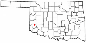
Knowles is a town in Beaver County, Oklahoma, United States. The population was 6 at the time of the 2020 census.
Dickson is a town in Carter County, Oklahoma, United States. The population was 1,207 at the 2010 census. It is part of the Ardmore, Oklahoma Micropolitan Statistical Area.

Springer is a town in Carter County, Oklahoma, United States. As of the 2020 census, the community had 685 residents. It is part of the Ardmore, Oklahoma Micropolitan Statistical Area.

Indiahoma is a town in Comanche County, Oklahoma, United States. It is located just south of US Route 62, about 24.4 driving miles west of Lawton.

North Enid is a town in Garfield County, Oklahoma, United States. The population was 860 at the 2010 census. The town is served by the Chisholm school district. North Enid was the original railroad town site in the Enid–Pond Creek Railroad War.

Ninnekah is a town in Grady County, Oklahoma, United States. The population was 775 at the 2020 census, a 22.7% decrease from 2010.

Pocasset is a town in Grady County, Oklahoma, United States. The population was 183 at the 2020 census, a 17.3% increase from 2010.
Willow is a town in Greer County, Oklahoma, United States. The population was 119 as of the 2020 United States census. It is situated about 13 miles north of the county seat of Mangum, just west of the concurrent US Route 283 and Oklahoma State Highway 34.
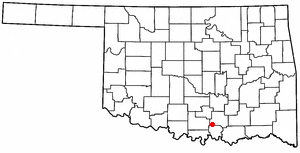
Mannsville is a town in Johnston County, Oklahoma, United States. The population was 728 as of the 2020 Census.

Tryon is a town in Lincoln County, Oklahoma, United States. The population was 491 at the 2010 census. The community is named after early land owner Fred S. Tryon.

Warwick is a town in Lincoln County, Oklahoma, United States. The population was 184 at the 2020 census, up from 148 in 2010.

Clearview is a town in Okfuskee County, Oklahoma, United States. The population was 41 at the 2020 Census. It was historically an all-black freedmen's town and was platted by the Lincoln Townsite Company and designated as Lincoln.

North Miami is a town in Ottawa County, Oklahoma, United States. The population was 290 at the 2020 census. The town is primarily a bedroom community for several larger towns in the county.

Maramec is a town in Pawnee County, Oklahoma, United States.The population was 66 as of the 2020 Census. It sits just north of the Cimarron Turnpike at N3550 Rd..

Foyil is a town in Rogers County, Oklahoma, United States. It was named for Alfred Foyil, a local landowner and the first postmaster of the town. The population was 344 at the 2010 census, a 47.0 percent increase over the figure of 234 recorded in 2000.

Randlett is a census-designated place (CDP) in west-central Uintah County, Utah, United States. In the 2000 census its population was 224, a 21% decrease from the 1990 figure of 283.

Capon Bridge is a town in eastern Hampshire County, West Virginia, United States, along the Northwestern Turnpike, approximately 20 miles (32 km) west of Winchester, Virginia. The population was 418 at the 2020 census. Originally known as "Glencoe", Capon Bridge was incorporated in 1902 by the Hampshire County Circuit Court. It is named because of the construction of the bridge over the Cacapon River at that place, the name of the river being derived from the Shawnee Cape-cape-de-hon, meaning "river of medicine water".
Port Wing is a town in Bayfield County, Wisconsin, United States. The population was 368 at the 2010 census. The unincorporated community of Port Wing is located in the town.

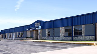
Hydro is a town in Caddo and Blaine counties in the U.S. state of Oklahoma. The population was 927 as of the 2020 United States census.


