Taovaya people

Last updated
Taovaya
Total population
fewer than 2,953 [1] (2018)
Regions with significant populations
Flag of Oklahoma.svg  Oklahoma,
historically Flag of Kansas.svg  Kansas and Flag of Texas.svg  Texas
Languages
English, Taovaya, Wichita
Religion
Native American Church, Christianity,
Indigenous religion
Related ethnic groups
Caddo, Pawnee, other Wichita and Affiliated Tribes

The Taovaya tribe of the Wichita people were Native Americans originally from Kansas, who moved south into Oklahoma and Texas in the 18th century. They spoke the Taovaya dialect of the Wichita language, a Caddoan language. Taovaya people today are enrolled in the Wichita and Affiliated Tribes, a federally recognized tribe headquartered in Anadarko, Oklahoma.

Contents

Synonymy

The Taovaya have also been called the Aijado, Tahuayase, Taouaize, Tawehash, Teguayo, Toaya, and Towash. [2]

Culture

Taovaya culture and language was closely related to those of other tribes of the Wichita. They were a semi-agrarian society whose main crops consisted of maize (corn), beans, melons, gourds, and tobacco. Hunting practices consisted of taking on bison, deer and other smaller game. [2]

Early history

The Taovaya and other Wichita tribes lived in beehive shaped houses thatched with grass and surrounded by fields of maize and other crops. Wichita Indian village 1850-1875.jpg
The Taovaya and other Wichita tribes lived in beehive shaped houses thatched with grass and surrounded by fields of maize and other crops.

The Taovaya are part of the Wichita tribes, which also include the Tawakoni, Waco (Iscani); and Guichita or Wichita Proper. [3] The Taovaya originated in Kansas, and possibly southern Nebraska. [2]

In 1541, Spanish conquistador Francisco Vásquez de Coronado led an expedition across the Great Plains in search of a rich land called Quivira. What he found were ancestral Wichita, a numerous farming and buffalo hunting people in central Kansas who possessed none of the wealth he sought. The furthest part of Quivira is believed to have been located on the Smoky Hill River near Lindsborg, Kansas. This area was called "Tabas", similar to the name Taovaya. [4]

From about 1630 to 1710, the Taovaya might have lived near present-day Marion, Kansas, where archaeological sites belonging to the Great Bend aspect have been discovered. [5]

18th-century history

In 1719, French explorer Claude Charles Du Tisne found two likely Taovaya villages of people he called "Paniouassa" near the present-day Neodesha, Kansas. "Pani" was a generic term the French called both Pawnee Indians and Wichita. That same year another French explorer Bernard de la Harpe visited a village, probably a few miles south of Tulsa, Oklahoma, in which the inhabitants were from several Wichita tribes including the "Toayas" or Taovayas. La Harpe said the Toavayas were said to be the most numerous of the Wichita. [6]

By the 18th century, the Osage encroached upon Wichita lands from the east, and the Apache from the west. In their Kansas and Oklahoma homelands, the Wichita were under intense pressure from both Osage and Apache. In the 1720s the Taovayas and their Guichita relatives began to move south to the Red River establishing a large village on the north side of the river in Jefferson County, Oklahoma, and on the south side at Spanish Fort, Texas. By the late 1750s, many of the Wichita tribes were living in Texas or across the Red River in Oklahoma.

The Taovaya were allied with the French, and in 1746 the French brokered a peace between the Taovaya and other Wichita with the Comanche. The Taovaya achieved their maximum influence during the next few decades. The village at Spanish Fort was "a lively emporium where Comanches brought Apache slaves, horses and mules to trade for French packs of powder, balls, knives, and textiles and for Taovayas-grown maize, melons, pumpkins, squash, and tobacco." [7]

The attack on San Saba mission is depicted in the earliest extant painting of an event in Texas history. SanSabaDestruction.jpg
The attack on San Sabá mission is depicted in the earliest extant painting of an event in Texas history.

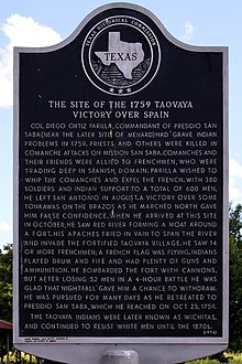
As French allies, the Taovaya ran afoul of the Spanish who had several posts and missions in southern Texas. In 1758, the Comanche, Taovaya, and other Wichita destroyed the San Sabá de la Santa Cruz mission of the Spanish. The next year the Spanish sent a 500-man army north to attack the Taovaya village at Spanish Fort, Texas. An Indian army met the Spaniards and routed them, capturing two cannons and killing or wounding about 50 of the Spaniards. [9] The unsuccessful Spanish attack on Taovaya villages in Texas and Oklahoma in 1759 is known as the Battle of the Twin Villages.

The Taovaya continued to wage war against the Spanish and their Lipan Apache allies while also in the 1760s acting peacefully towards the Spanish missions among the Hasinai, a Caddo tribe. In December 1764 Eyasiquiche, one of the prominent leaders among the Taovaya, led an attack against Spaniards and Apaches near Mission San Lorenzo de la Santa Cruz. In this attack a Spanish soldier, Antonio Trevino, was taken prisoner by the Taovoya. Originally Eyasiquiche planned to adopt Trevino into the Taovaya people, but, on learning he was from Los Adaes, Esquiche decided to return Trevino there. [10]

The French loss of their American colonies in 1763 in the French and Indian War interrupted the flow of trade goods to the Taovayas and made them more receptive to the Spanish. This process took years because the French traders remained in Louisiana, and it was not until Alejandro O'Reilly became governor that regulations were enacted that forbade French trading with the Taovaya. In 1771 the Taovayas, the other Wichita, and the Tonkawa made a peace agreement with the Spanish, defying the Comanche. The Taovaya trading empire was diminished by the Comanche and an epidemic, probably smallpox, that struck the Wichita in 1777 and 1778, killing more than 300 of them. [11] In 1778, the Taovaya village at Spanish Fort had 123 houses and across the Red River a Wichita town had another 37 houses. Together the two towns counted 600 men and a total population of probably around 2,500. [12] This however, was far less than the Wichita population in the time of Coronado when they numbered several tens of thousands. In 1801 another epidemic killed a great number of them. The American Indian agent Dr. John Sibley estimated in 1805 that they numbered 400 men. [13]

19th-century history

The Taovaya as a distinct tribe ended rather suddenly. In 1811, their chief, Awahakei, died during a visit to Americans in Natchitoches, Louisiana. The tribe did not select another leader and fragmented. Some joined the Tawakoni on the Brazos River. The Americans came to collectively call them "Wichita." [14]

In 1835, the Taovaya signed a treaty with the Americans and were relocated from Texas to an Indian reservation in southwest Indian Territory. [2]

Legacy

Taovaya Victory historical marker, Spanish Fort, Texas 1759 Taovaya Victory Historical Marker.jpg
Taovaya Victory historical marker, Spanish Fort, Texas

The site of the 1759 Taovaya victory over Spain during the Battle of the Twin Villages received a historic marker in 1976. [15] Its coordinates are 33°56′52.9434″N97°36′58.33″W / 33.948039833°N 97.6162028°W / 33.948039833; -97.6162028 (1759 Taovayo victory over Spain) .

The Taovayan Valley, a geographic region encompassing the area between the Wichita Mountains and the Red River of the South, is named after the tribe. The region was the tribe's last stronghold prior to removal to Indian Territory.

See also

Notes

  1. Gately, Paul (8 July 2018). "Native Americans chose Waco for water and abundance, like others". 10 KWTX. Retrieved 8 December 2018.
  2. 1 2 3 4 Jelks, Edward B. "Taovaya Indians". Texas State Historical Association. Retrieved 11 December 2018.
  3. Susan C. Vehik, "Wichita Culture History," Plains Anthropologist 37, no. 131 (1992): p. 311.
  4. Elizabeth Ann Harper [John], "The Taovaya Indians in Frontier Trade and Diplomacy 1719–1768," Chronicles of Oklahoma, 31, no. 3 (1953): p. 269.
  5. Vehik, 328; Roper, Donna C. "The Marion Great Bend Aspect Sits: Floodplain Settlement on the Plains." Plains Anthropologist, 47, no. 180 (2002): p. 17–32.
  6. Anna Lewis, "La Harpe's First Expedition in Oklahoma," Chronicles of Oklahoma, 2, no.4 (December 1924): p. 344.
  7. Earl Henry Elam, "Anglo-American Relations with the Wichita Indians in Texas, 1822–1859," Master's Thesis, Texas Technological College, 1967, p. 11.
  8. Sam D. Ratcliffe, "'Escenas de Maritiro': Notes on the Destruction of Mission San Sabá", The Southwestern Historical Quarterly, 94, no. 4 (April 1991): pp. 507–34.
  9. Elizabeth A. H. John, Storms Brewed in Other Men's Worlds (College Station: Texas A&M University Press, 1975), p. 32.
  10. Juliana Barr, Peace Came in the Form of a Woman: Indians and Spaniards in the Texas Borderlands (Chapel Hill: University of North Carolina, 2007), p. 197-99.
  11. Pekka Haalainen, The Comanche Empire (New Haven, CT: Yale University Press, 2008), p. 96-97; Earl Henry Elam, "Anglo-American Relations with the Wichita Indians in Texas, 1822–1839," "Archived copy" (PDF). Archived from the original (PDF) on 2011-08-15. Retrieved 2010-08-03.{{cite web}}: CS1 maint: archived copy as title (link), 18.
  12. "Archived copy" (PDF). Archived from the original (PDF) on 2011-08-15. Retrieved 2010-08-03.{{cite web}}: CS1 maint: archived copy as title (link), 17.
  13. "Archived copy" (PDF). Archived from the original (PDF) on 2011-08-15. Retrieved 2010-08-03.{{cite web}}: CS1 maint: archived copy as title (link), 19
  14. "Archived copy" (PDF). Archived from the original (PDF) on 2011-08-15. Retrieved 2010-08-03.{{cite web}}: CS1 maint: archived copy as title (link), pp. 19-20.
  15. Site of the 1759 Taovayo Victory Over Spain, From Nocona take FM 103 approximately 17 miles to Spanish Fort Marker is located next to large granite monument in center of town: Texas marker #4922.

Related Research Articles

<span class="mw-page-title-main">Pawnee people</span> Indigenous people of the Great Plains

The Pawnee are a Central Plains Indian tribe that historically lived in Nebraska and northern Kansas but today are based in Oklahoma. They are the federally recognized Pawnee Nation of Oklahoma, who are headquartered in Pawnee, Oklahoma. Their Pawnee language belongs to the Caddoan language family, and their name for themselves is Chatiks si chatiks or "Men of Men".

<span class="mw-page-title-main">Jefferson County, Oklahoma</span> County in Oklahoma, United States

Jefferson County is a county located in the U.S. state of Oklahoma. As of the 2020 census, the population was 5,337. Its county seat is Waurika. The county was created at statehood and named in honor of President Thomas Jefferson.

Lipan Apache are a band of Apache, a Southern Athabaskan Indigenous people, who have lived in the Southwest and Southern Plains for centuries. At the time of European and African contact, they lived in New Mexico, Colorado, Oklahoma, Texas, and northern Mexico. Historically, they were the easternmost band of Apache. Early adopters of horse culture and peyotism, the Lipan Apache hunted bison and farmed.

<span class="mw-page-title-main">Wichita people</span> Confederation of Native Americans

The Wichita people or Kitikiti'sh are a confederation of Southern Plains Native American tribes. Historically they spoke the Wichita language and Kichai language, both Caddoan languages. They are indigenous to Oklahoma, Texas, and Kansas.

<span class="mw-page-title-main">Comanche Wars</span> Conflicts over Comanche lands, 1706 to 1870s

The Comanche Wars were a series of armed conflicts fought between Comanche peoples and Spanish, Mexican, and American militaries and civilians in the United States and Mexico from as early as 1706 until at least the mid-1870s. The Comanche were the Native American inhabitants of a large area known as Comancheria, which stretched across much of the southern Great Plains from Colorado and Kansas in the north through Oklahoma, Texas, and eastern New Mexico and into the Mexican state of Chihuahua in the south. For more than 150 years, the Comanche were the dominant native tribe in the region, known as “the Lords of the Southern Plains”, though they also shared parts of Comancheria with the Wichita, Kiowa, and Kiowa Apache and, after 1840, the southern Cheyenne and Arapaho.

<span class="mw-page-title-main">Plains Indians</span> Native Americans/First Nations peoples of the Great Plains of North America.

Plains Indians or Indigenous peoples of the Great Plains and Canadian Prairies are the Native American tribes and First Nation band governments who have historically lived on the Interior Plains of North America. While hunting-farming cultures have lived on the Great Plains for centuries prior to European contact, the region is known for the horse cultures that flourished from the 17th century through the late 19th century. Their historic nomadism and armed resistance to domination by the government and military forces of Canada and the United States have made the Plains Indian culture groups an archetype in literature and art for Native Americans everywhere.

<span class="mw-page-title-main">Comanche history</span> History of Native American tribe

Comanche history is the story of the Native American (Indian) tribe which lived on the Great Plains of the present-day United States. In the 17th century the Eastern Shoshone people who became known as the Comanche migrated southward from Wyoming. In the 18th and 19th centuries the Comanche became the dominant tribe on the southern Great Plains. The Comanche are often characterized as "Lords of the Plains." They presided over a large area called Comancheria which they shared with allied tribes, the Kiowa, Kiowa-Apache, Wichita, and after 1840 the southern Cheyenne and Arapaho. Comanche power and their substantial wealth depended on horses, trading, and raiding. Adroit diplomacy was also a factor in maintaining their dominance and fending off enemies for more than a century. They subsisted on the bison herds of the Plains which they hunted for food and skins.

Quivira was a province of the ancestral Wichita people, located near the Great Bend of the Arkansas River in central Kansas, The exact site may be near present-day Lyons extending northeast to Salina.

<span class="mw-page-title-main">Tawakoni</span> Indigenous tribe in the United States

The Tawakoni are a Southern Plains Native American tribe, closely related to the Wichitas. They historically spoke a Wichita language of the Caddoan language family. Currently, they are enrolled in the Wichita and Affiliated Tribes, a federally recognized tribe.

Jean-Baptiste Bénard de la Harpe was a French explorer who is credited with using the name "Little Rock" in 1722 for a stone outcropping on the bank of the Arkansas River used by early travelers as a landmark. Little Rock, Arkansas was subsequently named for the landmark.

<span class="mw-page-title-main">Étienne de Veniard, Sieur de Bourgmont</span> French explorer (1679-1734)

Étienne de Veniard, Sieur de Bourgmont was a French explorer who documented his travels on the Missouri and Platte rivers in North America and made the first European maps of these areas in the early 18th century. He wrote two accounts of his travels, which included descriptions of the Native American tribes he encountered. In 1723, he established Fort Orleans, the first European fort on the Missouri River, near the mouth of the Grand River, and present-day Brunswick, Missouri. In 1724, he led an expedition to the Great Plains of Kansas to establish trading relations with the Padouca.

The Texas–Indian wars were a series of conflicts between settlers in Texas and the Southern Plains Indians during the 19th-century. Conflict between the Plains Indians and the Spanish began before other European and Anglo-American settlers were encouraged—first by Spain and then by the newly Independent Mexican government—to colonize Texas in order to provide a protective-settlement buffer in Texas between the Plains Indians and the rest of Mexico. As a consequence, conflict between Anglo-American settlers and Plains Indians occurred during the Texas colonial period as part of Mexico. The conflicts continued after Texas secured its independence from Mexico in 1836 and did not end until 30 years after Texas became a state of the United States, when in 1875 the last free band of Plains Indians, the Comanches led by Quahadi warrior Quanah Parker, surrendered and moved to the Fort Sill reservation in Oklahoma.

The Deer Creek/Bryson Paddock Sites are the remains of 18th century fortified villages of the Wichita tribe located along the Arkansas River in Kay County, Oklahoma.

<span class="mw-page-title-main">Mission Santa Cruz de San Sabá</span> Former Spanish mission in Texas

Mission Santa Cruz de San Sabá was one of the Spanish missions in Texas. It was established in April 1757, along with the Presidio San Luis de las Amarillas, later renamed Presidio of San Sabá, in what is now Menard County. Located along the San Saba River, the mission was intended to convert members of the Lipan Apache tribe. Although no Apache ever resided at the mission, its existence convinced the Comanche that the Spanish had allied with the Comanche's mortal enemy. In 1758 the mission was destroyed by 2,000 warriors from the Comanche, Tonkawa, Yojuane, Bidai and Hasinai tribes. It was the only mission in Texas to be completely destroyed by Native Americans. The Indians did not attack the nearby presidio.

Teyas were a Native American people living near what is now Lubbock, Texas, who first made contact with Europeans was the 1541 Francisco Vásquez de Coronado Expedition.

Jumanos were a tribe or several tribes, who inhabited a large area of western Texas, New Mexico, and northern Mexico, especially near the Junta de los Rios region with its large settled Indigenous population. They lived in the Big Bend area in the mountain and basin region. Spanish explorers first recorded encounters with the Jumano in 1581. Later expeditions noted them in a broad area of the Southwest and the Southern Plains.

Claude Charles du Tisné led the first official French expedition to visit the Osage and the Wichita Indians in 1719 in what became known as Kansas in the present-day United States.

<span class="mw-page-title-main">Waco people</span> North American indigenous tribe

The Waco of the Wichita people are a Southern Plains Native American tribe that inhabited northeastern Texas. Today, they are enrolled members of the federally recognized Wichita and Affiliated Tribes, headquartered in Anadarko, Oklahoma.

The Battle of the Two Villages was a Spanish attack on Taovaya villages in Texas and Oklahoma by a Spanish army in 1759. The Spanish were defeated by the Taovaya and other Wichita tribes with assistance from the Comanche.

Pedro Vial, or Pierre Vial, was a French explorer and frontiersman who lived among the Comanche and Wichita Indians for many years. He later worked for the Spanish government as a peacemaker, guide, and interpreter. He blazed trails across the Great Plains to connect the Spanish and French settlements in Texas, New Mexico, Missouri, and Louisiana. He led three Spanish expeditions that attempted unsuccessfully to intercept and halt the Lewis and Clark Expedition.