Spanish Fort, Texas

Last updated

Spanish Fort Site
SpanishFort1.jpg
Historical monument at Spanish Fort townsite
Relief map of Texas.png
Red pog.svg
Spanish Fort
Usa edcp relief location map.png
Red pog.svg
Spanish Fort
Nearest citySpanish Fort, Texas
Coordinates 33°57′7.2318″N97°37′36.0948″W / 33.952008833°N 97.626693000°W / 33.952008833; -97.626693000
Area10 acres (4.0 ha)
Built1759 (1759)
NRHP reference No. 75002000 [1]
Added to NRHPApril 14, 1975

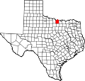
Spanish Fort is an unincorporated community in north-central Montague County, Texas, United States. According to the Handbook of Texas, the community had a population of 50 in 2000.

Contents

History

Spanish Fort was once a Taovaya Indian town that was fortified in the eighteenth century. Later Anglo immigrants who discovered Spanish artifacts and the ruins of a fort nearby gave the settlement the incorrect name. According to Spanish records, the Taovayas built two permanent settlements nearby, on either side of the Red River, between 1750 and 1757. According to legend, Col. Diego Ortiz Parrilla oversaw a campaign of revenge against Taovaya and Comanche Indians in 1759 after they had looted the Presidio San Luis de las Amarillas. The Taovayan town was guarded by some 6,000 Indians who were flying the French flag and was fortified with entrenchments, wooden stockades, and a moat when several hundred Spanish soldiers arrived. Four hours of fighting ended with the Spanish retreating. They even abandoned their two cannons and baggage train. The Spanish had established peace with the Indians by 1771, but continuing theft, particularly of horses, prompted Athanase de Mézières, the lieutenant governor of the Natchitoches province, to visit in 1778. He convinced the Taovayas to hand over the two cannons and gave the area the name San Teodoro.

Smallpox epidemics that started in 1778 and American expansion following the Louisiana Purchase in 1803 destroyed the population. The Taovayas abandoned their fortification in San Teodoro around 1841, allowing it to deteriorate. The Taovayas had long since left, so an early White settler who visited the ruins in 1859 didn't know anything about their past and imagined it had been a former Spanish fort. Near the site of San Teodoro, a town by the name of Burlington had grown by the early 1870s. For cattle drivers traveling toward the Chisholm Trail, it functioned as a watering spot. After bedding their herds at Red River Station, stockmen on the path rode to the nearby town of Burlington for supplies and entertainment. The community expanded swiftly, and locals petitioned for a post office in 1876. However, according to postal officials, their application was denied because another post office with the same name already existed in Texas. The incorrect name "Spanish Fort" was proposed by two local men in honor of the surrounding ruins. After the new name was approved, the post office in Spanish Fort was established in 1877. When the town was at its busiest, there were several shops and churches, a Masonic lodge, five doctors, four hotels, and a number of saloons, the most well-known of which was J. W. Schrock's Cowboy Saloon, where cattlemen gathered to partake in drinks and tell tales. Herman Joseph Justin started the boot business that eventually developed into Justin Industries in the town plaza. To have their personalized boots completed in time for them to pick them up on their trip south again, Justin took orders from the drivers heading north.

The Burlington Times and the Spanish Fort New Era were at least two newspapers that were published in Spanish Fort by 1884. By 1885, there were 300 residents, but Spanish Fort gained a reputation as a nasty town. Later, Justin's wife claimed that during the height of the cattle industry, there had been over 40 killings; in fact, on one Christmas morning, three men had been murdered before breakfast. Outlaws hiding out in Indian Territory traveled across the Red River to Spanish Fort to get supplies, frequently starting "affrays" that further troubled the town. When the cattle paths shifted further west and the Missouri, Kansas and Texas Railway omitted the town, the excitement at Spanish Fort eventually subsided. Justin relocated his boot business to the nearby town of Nocona in the late 1880s, where it flourished into the 1980s. Throughout the first 40 years of the 20th century, Spanish Fort's population stayed at around 250, and six enterprises remained in operation until 1941. By 1952, there were just 40 people left in the area as residents were drawn to locations with better employment possibilities. Around 1970, the post office and all but one of the businesses closed. Spanish Fort was practically a ghost town by the 1990s. After more than a century of farming by residents of Spanish Fort, the remains of the old Taovaya fortification vanished, but the location of the former San Teodoro was commemorated by a state historical monument built in 1936. The population of Spanish Fort was 50 in 2000, but the majority of the structures in the square remained vacant and abandoned. [2]

On February 10, 2009, an F4 tornado struck Spanish Fort. The strongest tornado of the outbreak touched down as a multiple vortex tornado just south of Spanish Fort initially snapping pecan trees. [3]

The Stonewall Saloon served as a resting stop for cowboys herding livestock on Texas trails. [4]

Geography

Spanish Fort is located at the end of Farm to Market Road 103, one mile south of the Red River, 26 mi (42 km) northeast of Montague, 17 mi (27 km) north of Nocona, and 37 mi (60 km) northeast of Bowie in north-central Montague County. [5]

Education

The first school in Spanish Fort opened in a log cabin in 1884. [2] Today, Spanish Fort is serviced by the Prairie Valley Independent School District.

Archeological Site of Spanish Fort

In 1965, Spanish Fort was excavated along the Red River of the South encompassing the geographies of Jefferson County, Oklahoma, and Montague County, Texas. [6] The excavation and surveying was for archeological and artifacts analysis purposes.

Historical record

Spanish Fort received historic markers in 1936 and 1976 recognizing the Taovaya tribe culture and the 1759 confrontation with a Spanish expedition. [7] [8] [9]

The Spanish Fort site was added to the National Register of Historic Places in 1975. [10]

Notable people

See also

Related Research Articles

<span class="mw-page-title-main">Montague County, Texas</span> County in Texas, United States

Montague County is a county located in the U.S. state of Texas, established in 1857. As of the 2020 census, its population was 19,965. The county seat is Montague. The county was created in 1857 and organized the next year. It is named for Daniel Montague, a surveyor and soldier in the Mexican–American War.

<span class="mw-page-title-main">Lampasas County, Texas</span> County in Texas, United States

Lampasas County is a county located on the Edwards Plateau in the U.S. state of Texas. As of the 2020 census, its population was 21,627. Its county seat is Lampasas. The county is named for the Lampasas River.

<span class="mw-page-title-main">Nocona, Texas</span> City in Texas, United States

Nocona is a city along U.S. Highway 82 and State Highway 175 in Montague County, Texas, United States. The population was 3,033 at the 2010 census. The city, its lake, and its resurgence as a regional travel destination were featured in the June 2012 edition of Texas Highways magazine.

<span class="mw-page-title-main">Quanah Parker</span> Native American Indian leader, Comanche (c. 1845–1911)

Quanah Parker was a war leader of the Kwahadi ("Antelope") band of the Comanche Nation. He was likely born into the Nokoni ("Wanderers") band of Tabby-nocca and grew up among the Kwahadis, the son of Kwahadi Comanche chief Peta Nocona and Cynthia Ann Parker, an Anglo-American who had been abducted as an eight-year-old child and assimilated into the Nokoni tribe. Following the apprehension of several Kiowa chiefs in 1871, Quanah Parker emerged as a dominant figure in the Red River War, clashing repeatedly with Colonel Ranald S. Mackenzie. With European-Americans hunting American bison, the Comanches' primary sustenance, into near extinction, Quanah Parker eventually surrendered and peaceably led the Kwahadi to the reservation at Fort Sill, Oklahoma.

<span class="mw-page-title-main">Charles Goodnight</span> American rancher in the Texas Panhandle (1836-1929)

Charles Goodnight, also known as Charlie Goodnight, was a rancher in the American West. In 1955, he was inducted into the Hall of Great Westerners of the National Cowboy & Western Heritage Museum.

<span class="mw-page-title-main">Fort Crown Point</span> United States historic place

Fort Crown Point was built by the combined efforts of both British and provincial troops in North America in 1759 at a narrows on Lake Champlain on what later became the border between New York and Vermont. Erected to secure the region against the French, the fort is in upstate New York near the town of Crown Point and was the largest earthen fortress built in the United States. The fort's ruins, a National Historic Landmark, are now administered as part of Crown Point State Historic Site.

<span class="mw-page-title-main">Fort Griffin</span> United States historic place

Fort Griffin, now a Texas state historic site as Fort Griffin State Historic Site, was a US Cavalry fort established 31 July 1867 by four companies of the Sixth Cavalry, U.S. Army under the command of Lt. Col. S. D. Sturgis, in the western part of North Texas, specifically northwestern Shackelford County, to give settlers protection from early Comanche and Kiowa raids. Originally called Camp Wilson after Henry Hamilton Wilson, a recently deceased lieutenant and son of Radical Republican senator and later vice president, Henry Wilson, it was later named for Charles Griffin, a former Civil War Union general who had commanded, as de facto military governor, the Department of Texas during the early years of Reconstruction.

Herman Joseph Justin was born in Lafayette, Indiana. Justin's father's profession, cigar making, didn't suit H. J., so he moved to Texas in 1877 at the age of 18. First settling in Gainesville, Texas at a time when Native American raids from the Indian Territory were just beginning to wane, Justin was first employed as a shoe repairman at a local Gainesville shop. After a few years working on shoes, he moved 40 miles (64 km) west to the fledgling town of Burlington, Texas in Montague County, Texas and opened a boot shop with a $35 loan from the local barber.

Belcherville is an unincorporated community in Montague County, Texas, United States. According to the Handbook of Texas, the community had a population of 34 in 2000.

<span class="mw-page-title-main">Red River Station, Texas</span> Ghost Town in Texas, United States

Red River Station is a ghost town south of the Red River at Salt Creek in northwestern Montague County, Texas, United States.

Bonita is an unincorporated community in north-central Montague County, Texas, United States. According to the Handbook of Texas, the community had a population of 25 in 2000.

<span class="mw-page-title-main">Fort McKavett State Historic Site</span> United States historic place

The Fort McKavett State Historic Site is a former United States Army installation located in Menard County, Texas. The fort was first established in 1852 as part of a line of forts in Texas intended to protect migrants traveling to California. The fort was deemed unnecessary and abandoned in 1859 and was occupied by settlers. From 1861 to 1863, during the American Civil War, the fort became an outpost of Confederate forces on the Texas frontier until they left for other theaters of the war. When the US Army returned to Texas in the later 1860s, the fort was reoccupied and rebuilt, and became a base for the "Buffalo Soldier", or all-African American, 24th Infantry and 9th Cavalry Regiments.

<span class="mw-page-title-main">Battle of Pease River</span> Raid against Comanche Indians by Texas Rangers and militia

The Battle of Pease River, also known as the Pease River Massacre or the Pease River fight, occurred on December 19, 1860, near the present-day town of Margaret, Texas in Foard County, Texas, United States. The town is located between Crowell and Vernon within sight of the Medicine Mounds just outside present-day Quanah, Texas.

<span class="mw-page-title-main">Mission Santa Cruz de San Sabá</span> Former Spanish mission in Texas

Mission Santa Cruz de San Sabá was one of the Spanish missions in Texas. It was established in April 1757, along with the Presidio San Luis de las Amarillas, later renamed Presidio of San Sabá, in what is now Menard County. Located along the San Saba River, the mission was intended to convert members of the Lipan Apache tribe. Although no Apache ever resided at the mission, its existence convinced the Comanche that the Spanish had allied with the Comanche's mortal enemy. In 1758 the mission was destroyed by 2,000 warriors from the Comanche, Tonkawa, Yojuane, Bidai and Hasinai tribes. It was the only mission in Texas to be completely destroyed by Native Americans. The Indians did not attack the nearby presidio.

The Taovaya tribe of the Wichita people were Native Americans originally from Kansas, who moved south into Oklahoma and Texas in the 18th century. They spoke the Taovaya dialect of the Wichita language, a Caddoan language. Taovaya people today are enrolled in the Wichita and Affiliated Tribes, a federally recognized tribe headquartered in Anadarko, Oklahoma.

Adobe Walls is a ghost town in Hutchinson County, 17 miles (27 km) northeast of Stinnett, in the U.S. state of Texas. It was established in 1843 as a trading post for buffalo hunters and local Native American trade in the vicinity of the Canadian River. It later became a ranching community. Historically, Adobe Walls is the site of two decisive battles between Native Americans and settlers. In November 1864 First Battle of Adobe Walls, Native Americans successfully repelled attacking troops led by Kit Carson. Ten years later, on June 27, 1874, known as the Second Battle of Adobe Walls, civilians at the Adobe Walls trading post successfully fought off an attack by a war party of mainly Comanche and Cheyenne warriors led by the Comanche chief Quanah Parker. The second battle led to a military campaign which resulted in Indian relocation to Indian Territory.

The Battle of the Two Villages was a Spanish attack on Taovaya villages in Texas and Oklahoma by a Spanish army in 1759. The Spanish were defeated by the Taovaya and other Wichita tribes with assistance from the Comanche.

<span class="mw-page-title-main">Stonewall Saloon (Texas)</span> Museum in Montague County, Texas

Stonewall Saloon or The Museum of the Stonewall Saloon is an authentic western saloon located in Saint Jo, Texas. The tavern was named as acknowledgment of Stonewall Jackson as American Civil War exiles appealed for sanctuary in what was termed "Indian country." The saloon was established in 1873 during the eminence of the cattle drive era exemplary of the late nineteenth century Old West.

<span class="mw-page-title-main">Blockhouse on Signal Mountain (Oklahoma)</span> Blockhouse on Signal Mountain in Southwest Oklahoma

Blockhouse on Signal Mountain is located along Mackenzie Hill Road within the West Range of the Fort Sill Military Reservation inceptively declared as Camp Wichita during May 1868 within the current administrative division of Comanche County, Oklahoma. The blockhouse was established in 1871 pursuant to the Medicine Lodge Treaty of 1867.

References

  1. "National Register Information System". National Register of Historic Places . National Park Service. July 9, 2010.
  2. 1 2 Spanish Fort, TX from the Handbook of Texas Online
  3. "The Severe Weather and Tornado Event of February 10, 2009". National Weather Service Forecast Office in Norman, Oklahoma. Retrieved April 18, 2023.
  4. "The Most Dangerous Prairie in Texas" [Fort Griffin and the Prairie-Plains Frontier], Texas Beyond History (TBH), Austin, Texas: University of Texas at Austin
  5. "Spanish Fort, Texas". Texas Escapes Online Magazine. Retrieved September 12, 2023.
  6. Jelks, Edward B. "Spanish Fort Sites". Handbook of Texas Online. Texas State Historical Association.
  7. "Spanish Fort - Marker No. 5000". Texas Historic Sites Atlas . Texas Historical Commission. 1936.
  8. "Site of the 1759 Taovayo Victory Over Spain - Marker No. 4922". Texas Historic Sites Atlas. Texas Historical Commission. 1976.
  9. "Spanish Fort" [Nocona in Montague County, Texas - The American South (West South Central)]. HMDB.org. The Historical Marker Database.
  10. "Spanish Fort Site - NRHP No. 75002000". Texas Historic Sites Atlas. Texas Historical Commission. April 14, 1975.
  11. John 1996, pp. 662–668.
  12. Chipman, Donald E. and Joseph, Harriet Denise, Notable Men and Women of Spanish Texas Austin: University of Texas Press, 1999, p. 213-215

Commons-logo.svg Media related to Spanish Fort, Texas at Wikimedia Commons