Illinois Bend, Texas

Last updated

Illinois Bend, Texas
USA Texas location map.svg
Red pog.svg
Illinois Bend
Location within Texas
Usa edcp location map.svg
Red pog.svg
Illinois Bend
Illinois Bend (the United States)
Coordinates: 33°52′54″N97°29′14″W / 33.88167°N 97.48722°W / 33.88167; -97.48722
Country United States
State Texas
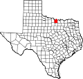
County Montague
Settled1862
Founded byC. M. Ward
Elevation
797 ft (243 m)
Time zone UTC-6 (CST)

Illinois Bend is an unincorporated community in Montague County, Texas, United States. According to the Handbook of Texas, the community had a population of 30 in 2000.

Contents

History

The community was founded in 1862 by a small group of people who relocated to Texas from Illinois. It was formerly known as Wardville after the local landowner C. M. Ward. When a post office was established there in 1877, the name was changed to Illinois Bend. The community had 300 residents, two gristmills, numerous cotton gins, and several churches in 1885. Due to rail lines avoiding the village, its population had decreased to 112 by 1910. In the late 1940s, when one business was there, there were 68 residents. Sometime around 1930, the community's post office was shut down. There were just 51 people living in Illinois Bend by the late 1960s. The population had decreased to thirty by 2000. [1] It then went up to 40 in 2020. [2]

Early settlers were plagued by occasional raids from Comanche and Kiowa Indians who had been placed in the Leased Lands north of the Red River and on the eastern border of the Chickasaw Nation. [3]

On May 15, 2013, an F0 tornado struck Illinois Bend. It damaged a home and downed several trees. [4] Another tornado reportedly struck the community on March 20, 1955, injuring one. [5]

Geography

Illinois Bend is located on Farm to Market Road 677, 20 mi (32 km) northeast of Montague in the extreme northeastern corner of Montague County. [1]

Education

Illinois Bend had its own school in 1885. [1] Today, the community is served by the Saint Jo Independent School District.

Related Research Articles

Independence is an unincorporated community in Washington County, Texas, United States. According to the Handbook of Texas, the community had a population of 140 in 2000. It is located within the Greater Houston metropolitan area.

Ratcliff is an unincorporated community in Houston County, Texas, in East Texas, United States. According to the Handbook of Texas, the community had a population of 106 in 2000.

Apple Springs is a small unincorporated community in Trinity County, Texas, United States. According to the Handbook of Texas, the community had a population of 185 in 2000. It is located within the Huntsville, Texas micropolitan area.

Malta is an unincorporated community in Bowie County, Texas, United States. According to the Handbook of Texas, the community had a population of 297 in 1990. It is part of the Texarkana metropolitan area.

Stoneburg is an unincorporated community in Montague County, Texas, United States. According to the Handbook of Texas, it had a population of approximately 51 in 2000.

Forestburg is an unincorporated community in Montague County, Texas, United States. According to the Handbook of Texas, the community had a population of 50 in 2000.

Belcherville is an unincorporated community in Montague County, Texas, United States. According to the Handbook of Texas, the community had a population of 34 in 2000.

Bonita is an unincorporated community in north-central Montague County, Texas, United States. According to the Handbook of Texas, the community had a population of 25 in 2000.

Centralia is an unincorporated community in Trinity County, Texas, United States. In 2000, the estimated population was 53 residents. It is located within the Huntsville, Texas micropolitan area.

Pennington is an unincorporated community in Houston and Trinity counties in the U.S. state of Texas. Although it is unincorporated, it has a post office with a zip code of 75856. Its population as of 2021 is 173.

<span class="mw-page-title-main">February 2009 North American storm complex</span> 2009 storm complex in the United States

On February 10–11, 2009, a broad-scale damaging wind event and small tornado outbreak affected the Central and Eastern United States. During the two-day period, 14 tornadoes touched down in seven states. Oklahoma was struck by six tornadoes, the most of any state. The six tornadoes in Oklahoma also tied the record for the most tornadoes ever recorded in the state during the month of February, which would later be broken in 2023. The first day of the outbreak produced the most tornadoes; the second brought mainly high wind damage and rain or snow in most of the Northeast.

Glen Flora is an unincorporated community in Wharton County, Texas, United States. According to the Handbook of Texas, the community had an estimated population of 210 in 2000. It is located within the Greater Houston metropolitan area.

<span class="mw-page-title-main">Lane City, Texas</span> Unincorporated community in Texas, United States

Lane City is an unincorporated community in Wharton County, Texas, United States. According to the Handbook of Texas, the community had an estimated population of 111 in 2000. It is located within the Greater Houston metro area.

Weldon is an unincorporated community in Houston County, Texas. According to the Handbook of Texas, the community had a population of 131 in 2000.

McMahan is an unincorporated community in Caldwell County, in the U.S. state of Texas. According to the Handbook of Texas, the community had a population of 125 in 2000. It is located within the Greater Austin metropolitan area.

Concord is an unincorporated community in Rusk County, Texas. According to the Handbook of Texas, the community had a population of 23 in 2000. It is located within the Longview, Texas metropolitan area.

<span class="mw-page-title-main">Tornadoes of 1954</span>

This page documents the tornadoes and tornado outbreaks of 1954, primarily in the United States. Most tornadoes form in the U.S., although some events may take place internationally. Tornado statistics for older years like this often appear significantly lower than modern years due to fewer reports or confirmed tornadoes.

This page documents the tornadoes and tornado outbreaks of 1950, primarily in the United States. Most tornadoes form in the U.S., although some events may take place internationally.

Clawson is an unincorporated community in Angelina County, in the U.S. state of Texas. According to the Handbook of Texas, it had a population of 195 in 2000. It is located within the Lufkin, Texas micropolitan area.

Carlson is an unincorporated community in Travis County, in the U.S. state of Texas. According to the Handbook of Texas, the community had a population of 61 in 2000. It is located within the Greater Austin metropolitan area.

References

  1. 1 2 3 Illinois Bend, TX from the Handbook of Texas Online
  2. "Illinois Bend, Texas". Texas Escapes Online Magazine. Retrieved September 11, 2023.
  3. Trevis, Michael. "Montague County Historical Markers" . Retrieved September 11, 2023.
  4. "Storm Events Database - Event Details | National Centers for Environmental Information". National Centers for Environmental Information. 2013. Retrieved February 3, 2023.
  5. "1955 Tornadoes". Tornado Archive. Retrieved July 18, 2022.