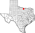
Belcherville, Texas

Last updated

Belcherville
USA Texas location map.svg
Red pog.svg
Belcherville
Location within Texas
Usa edcp location map.svg
Red pog.svg
Belcherville
Belcherville (the United States)
Coordinates: 33°48′09″N97°49′56″W / 33.80250°N 97.83222°W / 33.80250; -97.83222
Country United States
State Texas
County Montague
Time zone UTC-6 (CST)

Belcherville is an unincorporated community in Montague County, Texas, United States. According to the Handbook of Texas, the community had a population of 34 in 2000.

Contents

History

The town was originally known as Belcher, after local ranchers and landowners John and Alex Belcher, but by 1858 it had changed its name to Belcherville. The village, however, existed only as the Belcher Ranch's administrative center until 1887, when the Belchers bought 27,000 acres (11,000 ha) of land and laid up a townsite in anticipation of the Gainesville, Henrietta and Western Railway's extension through the area. That year saw the opening of a post office. Belcherville's expansion as a regional cattle and cotton shipping hub was aided by the train link and the nearby Red River Station's almost total destruction by a storm in 1890. More than twenty firms were operating there by the time it was founded in 1893. Belcherville had thirty companies and 305 persons by 1900. The municipality suffered over the twentieth century, and in 1908, locals decided to vote to rescind the charter of incorporation. Following World War I, two fires significantly damaged the local business district, and it appears that many businesses relocated to Nocona. Belcherville had 192 residents in the middle of the 1920s and 85 in the middle of the 1930s when five enterprises were running there. After 1930, the post office eventually shut down. The population of Belcherville then fluctuated, reaching ninety-four by the middle of the 1940s, dropping to thirty-one by the middle of the 1950s, and rising to ninety by the late 1960s, when there were no recorded enterprises. Since it was reportedly the smallest incorporated town in the United States in 1958, the municipality may have reincorporated in the first half of the 20th century. In the period between the 1960s and 2000, Belcherville's population was 34. [1]

On February 10, 2009, an EF0 tornado struck Belcherville. It destroyed several outbuildings and two sheds, blew down a back door, and damaged the roof of one home. Two trees were uprooted and a water tank was flipped. Damages from the tornado were estimated at $20,000. [2] Another EF0 tornado struck the town on May 15, 2013, causing damage to a ranch. [3]

Geography

Belcherville is located at the intersection of U.S. Route 82 and Farm to Market Road 1816, 15 mi (24 km) northwest of Montague and 6 mi (9.7 km) west of Nocona in northwestern Montague County. [4]

Education

Belcherville had two schools in 1900. [1] Today, Belcherville is served by the Nocona Independent School District.

Notable people

Related Research Articles

Ratcliff is an unincorporated community in Houston County, Texas, in East Texas, United States. According to the Handbook of Texas, the community had a population of 106 in 2000.

Sidney is an unincorporated community located in Comanche County in the U.S. state of Texas. According to the Handbook of Texas, the community had a population of 196 in 2000.

Illinois Bend is an unincorporated community in Montague County, Texas, United States. According to the Handbook of Texas, the community had a population of 30 in 2000.

<span class="mw-page-title-main">Spanish Fort, Texas</span> United States historic place

Spanish Fort is an unincorporated community in north-central Montague County, Texas, United States. According to the Handbook of Texas, the community had a population of 50 in 2000.

Bonita is an unincorporated community in north-central Montague County, Texas, United States. According to the Handbook of Texas, the community had a population of 25 in 2000.

Shannon is an unincorporated community in Clay County, Texas, United States. According to the Handbook of Texas, the community had a population of 23 in 2000. It is located within the Wichita Falls metropolitan area.

Joy is an unincorporated community in southern Clay County, Texas, United States. According to the Handbook of Texas, the community had a population of 100 in 2000. It is located within the Wichita Falls metropolitan area.

Silver is an unincorporated community in northwestern Coke County, Texas, United States. According to the Handbook of Texas, the community had a population of 60 in 2000.

Tennyson is an unincorporated community in southeastern Coke County, Texas, United States. According to the Handbook of Texas, the community had a population of 35 in 2000.

Burkett is an unincorporated community in Coleman County, Texas, United States. According to the Handbook of Texas, the community had a population of 30 in 2000.

<span class="mw-page-title-main">Tornado outbreak sequence of May 5–10, 2015</span> Weather event in the United States

The tornado outbreak sequence of May 5–10, 2015 was a six-day outbreak of tornado activity that affected the Great Plains of the United States in early May 2015. On May 6, strong tornadoes impacted the Oklahoma City area, along with rural parts of Kansas, Texas, Arkansas, South Dakota, and Nebraska. The outbreak coincided with major flooding, with large amounts of rain falling in parts of Nebraska, Kansas, Oklahoma, and Texas. The National Weather Service forecast office in Norman, Oklahoma issued a "flash flood emergency" for Oklahoma City following record-breaking rainfall that occurred in the area that evening. The outbreak sequence resulted in five tornado-related deaths, along with two flood-related deaths. A total of 127 tornadoes were confirmed and rated as a result of this outbreak sequence. Damage from the outbreak was estimated at $1.5 billion.

<span class="mw-page-title-main">Tornado outbreak of February 23–24, 2016</span> Weather event in the United States

An unusually prolific and very destructive late-winter tornado outbreak resulted in significant damage and numerous casualties across the southern and eastern half of the United States between February 23–24, 2016. Lasting over a day and a half, the outbreak produced a total of 61 tornadoes across eleven states, which ranked it as one of the largest February tornado outbreaks in the United States on record, with only the 2008 Super Tuesday tornado outbreak having recorded more. In addition, it was also one of the largest winter tornado outbreaks overall as well. The most significant and intense tornadoes of the event were four EF3 tornadoes that struck southeastern Louisiana, Pensacola, Florida, Evergreen, Virginia, and Tappahannock, Virginia. Tornadoes were also reported in other places like Texas, Florida, and Pennsylvania. Severe thunderstorms, hail and gusty winds were also felt in the Northeastern United States and Mid-Atlantic states on February 24 as well.

<span class="mw-page-title-main">Tornado outbreak and floods of April 28 – May 1, 2017</span> 2017 severe weather in central US

Between April 28 – May 1, 2017, a series of severe weather events affected the Central United States, producing life-threatening flooding and a major tornado outbreak. It formed out of a disturbance in the Southwestern United States on April 28, and caused significant impacts, including a heavy snowstorm in the Rockies, and other types of severe weather. Up to 3 feet (36 in) of snow fell on the cold side of the system, and up to a foot of rain fell in and around the central parts of the nation.

<span class="mw-page-title-main">Tornado outbreak of April 13–15, 2019</span> Severe weather effect in the Southeastern United States

A significant severe weather and tornado outbreak affected multiple regions of the Eastern United States in mid-April 2019. Over the course of 40 hours, 75 tornadoes touched down. The outbreak produced numerous strong tornadoes throughout portions of the Deep South, while additional significant tornadoes occurred as far north as Ohio, Pennsylvania, and Delaware. The most significant tornado of the event was a long-tracked, high-end EF3 tornado that struck Alto, Texas and killed two people. Numerous weak tornadoes were also confirmed, along with numerous reports of hail and damaging straight line winds.

<span class="mw-page-title-main">Tornado outbreak of October 20–22, 2019</span> Weather event in the United States

A significant severe weather event impacted the South Central United States between October 20–22, 2019. Forecasters first identified the threat on October 16 as a large upper-level trough was expected to combine with an unstable atmosphere across Texas, Oklahoma, and Arkansas particularly. On the evening of October 20, discrete supercell thunderstorms developed across the Dallas–Fort Worth metroplex, contributing to several tornadoes. One of those tornadoes caused EF3 damage in the Dallas suburbs, becoming the costliest tornado event in Texas history, at $1.55 billion. A later squall line contributed to additional tornadoes and a widespread swath of damaging winds as the system tracked eastward.

<span class="mw-page-title-main">Tornado outbreak of April 21–23, 2020</span> Weather event in the United States

On April 22, 2020, an outbreak of discrete supercell thunderstorms across portions of Oklahoma, Texas, and Louisiana led to widespread severe weather, including multiple strong tornadoes. Two people were killed by a high-end EF2 that struck the town of Madill, Oklahoma, and three more were killed by an EF3 wedge tornado that moved through Onalaska, Texas. Dozens of others were injured as well. The event came to fruition as a trough progressed eastward across the United States, interacting with a moist and unstable environment. Tornado activity continued into Arkansas, Louisiana, Mississippi, Alabama, Florida, and Georgia overnight into the day on April 23. Isolated tornado activity also occurred during the overnight hours on April 21.

<span class="mw-page-title-main">Tornado outbreak of March 21–23, 2022</span> Spring tornado outbreak in the Southern United States

A large tornado outbreak struck the Southern region of the United States on March 21–22, 2022, before transitioning to the Eastern United States on March 23. The outbreak started with numerous supercell thunderstorms and severe squall lines developing in central Texas and southern Oklahoma, prompting the issuance of numerous tornado warnings, including multiple PDS tornado warnings. An EF3 tornado caused considerable damage in Jacksboro, Texas while an EF2 tornado from the same storm caused a fatality in Sherwood Shores. Other strong tornadoes caused damage near College Station and in the Austin and Houston metropolitan areas. Severe and tornadic activity continued into the next day as the system moved eastward with numerous tornadoes reported in Mississippi and Alabama. On the evening of March 22, a supercell moved through the New Orleans metropolitan area, with an EF3 tornado producing severe damage in Arabi, resulting in one death and at least two injuries. Widespread flooding also accompanied the decaying squall line in Alabama. Tornadoes occurred on March 23 over the Eastern United States, associated with the same system, including EF2 tornadoes near Pickens, South Carolina, and Gladesboro, Virginia. In all, 85 tornadoes were confirmed.

<span class="mw-page-title-main">Tornado outbreak sequence of April 4–7, 2022</span> Tornadoes in the Southeastern U.S.

From April 4–5, 2022, a mesoscale convective system and numerous discrete supercells produced a swath of severe weather and several tornadoes in the Southeastern United States, including several strong, long tracked tornadoes. An EF3 tornado damaged or destroyed several homes in Bonaire, Georgia while a large EF3 tornado prompted a tornado emergency for Allendale and Sycamore, South Carolina. A violent EF4 tornado in Black Creek, Georgia resulted in one fatality as it destroyed several neighborhoods, and another large EF3 tornado caused widespread heavy tree damage northeast of Ulmer, South Carolina. More severe storms occurred across a large portion of the Southeast ahead of a cold front on April 6–7, with more tornadoes reported in South and Central Georgia and further south into Florida, all of which were weak. Along with the one tornadic death, trees felled by straight-line winds killed one person each in Louisiana and Texas.

<span class="mw-page-title-main">April 2022 North American storm complex</span> 2022 American storm complex

The April 2022 North American storm complex affected much of the Rocky Mountains and the Midwestern United States with tornadoes, heavy snow, and gusty winds. The system in general first began impacting the Northwest on April 11, before moving eastward into the Rocky Mountains the following day. It was also responsible for producing a large severe weather outbreak of tornadoes and damaging straight-line wind in the Midwest and South while contributing to a powerful blizzard in the upper Midwest states of North and South Dakota.

Lutie is an unincorporated community in Collingsworth County, in the U.S. state of Texas. According to the Handbook of Texas, the community had a population of 35 in 1990.

References

  1. 1 2 Belcherville, TX from the Handbook of Texas Online
  2. "[Texas Event Report: EF0 Tornado]". National Centers for Environmental Information. National Weather Service Forecast Office in Fort Worth/Dallas, Texas. Retrieved April 18, 2023.
  3. "Storm Events Database - Event Details | National Centers for Environmental Information". National Centers for Environmental Information. 2013. Retrieved February 3, 2023.
  4. "Belcherville, Texas". Texas Escapes Online Magazine. Retrieved September 11, 2023.
  5. Parrish, Michael (2001). For the People: Inside the Los Angeles County District Attorney's Office 1850-2000. Angel City Press. ISBN   978-1883318154.
  6. Application for Social Security and Tax Account Number dated February 17, 1965 and signed by Foy E. Wallace, Jr.