
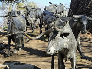
The Texas Longhorn is an American breed of beef cattle, characterized by its long horns, which can span more than 8 ft (2.4 m) from tip to tip. It derives from cattle brought from the Iberian Peninsula to the Americas by Spanish conquistadores from the time of the Second Voyage of Christopher Columbus until about 1512. For hundreds of years the cattle lived a semi-feral existence on the rangelands; they have a higher tolerance of heat and drought than most European breeds. It can be of any color or mix of colors. In some 40% of the cattle it is some shade of red, often a light red; the only shade of red not seen is the deep color typical of the Hereford.

Saint Jo is a city in Montague County, Texas, United States, along the northern border of the state. The population was 1,043 at the 2010 census.
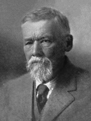
Charles Goodnight, also known as Charlie Goodnight, was a rancher in the American West. In 1955, he was inducted into the Hall of Great Westerners of the National Cowboy & Western Heritage Museum.
John Horton Slaughter, also known as Texas John Slaughter, was an American lawman, cowboy, poker player and rancher in the Southwestern United States during the late 19th and early 20th centuries. After serving in the Confederate States Army during the American Civil War, Slaughter earned a reputation fighting hostile Indians and Mexican and American outlaws in the Arizona and New Mexico territories. In the latter half of his life, he lived at the San Bernardino Ranch, which is today a well-preserved National Historic Landmark in Cochise County in far southeastern Arizona. In 1964, he was inducted into the Hall of Great Westerners of the National Cowboy & Western Heritage Museum.

Oliver Loving was an American rancher and cattle driver. Together with Charles Goodnight, he developed the Goodnight-Loving Trail. He was mortally wounded by Native Americans while on a cattle drive.

The Chisholm Trail was a trail used in the post-Civil War era to drive cattle overland from ranches in Texas to Kansas railheads. The trail was established by Black Beaver, a Lenape guide and rancher, and his friend Jesse Chisholm, a Cherokee merchant. They collected and drove numerous cattle along the trail to Kansas, where they could be shipped east to achieve higher prices. The southern terminus was Red River Station, a trading post near the Red River along the northern border of Texas. The northern terminus was a trading post near Kansas City, Kansas. Chisholm owned both of these posts. In the years of the cattle drives, cowboys drove large herds from ranches across Texas to the Red River Station and then north to Kansas City.
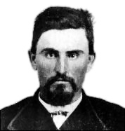
Jesse Chisholm was a Scotch-Cherokee fur trader and merchant in the American West. He is known for having scouted and developed what became known as the Chisholm Trail, later used to drive cattle from Texas to railheads in Kansas in the post-Civil War period.
The Texas Road, also known as the Shawnee Trail, Sedalia Trail, or Kansas Trail, was a major trade and emigrant route to Texas across Indian Territory. Established during the Mexican War by emigrants rushing to Texas, it remained an important route across Indian Territory until Oklahoma statehood. The Shawnee Trail was the earliest and easternmost route by which Texas Longhorn cattle were taken to the north. It played a significant role in the history of Texas, Oklahoma, Missouri, and Kansas in the early and mid-1800s.

Cattle drives were a major economic activity in the 19th and early 20th century American West, particularly between 1850s and 1910s. In this period, 27 million cattle were driven from Texas to railheads in Kansas, for shipment to stockyards in St. Louis and points east, and direct to Chicago. The long distances covered, the need for periodic rests by riders and animals, and the establishment of railheads led to the development of "cow towns" across the frontier.

Fort Griffin, now a Texas state historic site as Fort Griffin State Historic Site, was a US Cavalry fort established 31 July 1867 by four companies of the Sixth Cavalry, U.S. Army under the command of Lt. Col. S. D. Sturgis, in the western part of North Texas, specifically northwestern Shackelford County, to give settlers protection from early Comanche and Kiowa raids. Originally called Camp Wilson after Henry Hamilton Wilson, a recently deceased lieutenant and son of Republican senator and later vice president, Henry Wilson, it was later named for Charles Griffin, a former Civil War Union general who had commanded, as de facto military governor, the Department of Texas during the early years of Reconstruction.

The Great Western Cattle Trail is the name used today for a cattle trail established during the late 19th century for moving beef stock and horses to markets in eastern and northern states. It is also known as the Western Trail, Fort Griffin Trail, Dodge City Trail, Northern Trail and Texas Trail. It ran west of and roughly parallel to the better known Chisholm Trail into Kansas, reaching an additional major railhead there for shipping beef to Chicago, or longhorns and horses continuing on further north by trail to stock open-range ranches in the Dakotas, Wyoming, Montana, and two provinces in Canada. A full-length drive from the trailhead south of Bandera, Texas took almost one hundred days to reach its destination in Kansas.

Spanish Fort is an unincorporated community in north-central Montague County, Texas, United States. According to the Handbook of Texas, the community had a population of 50 in 2000.
Fort Richardson was a United States Army installation located in present-day Jacksboro, Texas. Named in honor of Union General Israel B. Richardson, who died in the Battle of Antietam during the American Civil War, it was active from 1867 to 1878. Today, the site, with a few surviving buildings, is called Fort Richardson State Park, Historic Site and Lost Creek Reservoir State Trailway. It was designated a National Historic Landmark in 1963 for its role in securing the state's northern frontier in the post-Civil War era.

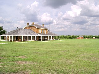
The Fort McKavett State Historic Site is a former United States Army installation located in Menard County, Texas. The fort was first established in 1852 as part of a line of forts in Texas intended to protect migrants traveling to California. The fort was deemed unnecessary and abandoned in 1859 and was occupied by settlers. From 1861 to 1863, during the American Civil War, the fort became an outpost of Confederate forces on the Texas frontier until they left for other theaters of the war. When the US Army returned to Texas in the later 1860s, the fort was reoccupied and rebuilt, and became a base for the "Buffalo Soldier", or all-African American, 24th Infantry and 9th Cavalry Regiments.
Preston Trail, later known as the Old Preston Road, was a road created by the Republic of Texas in 1841 from Preston, Texas on the Red River south to Austin, Texas. This road closely followed an existing trail that led across the area that had been used for centuries. This road was a main transportation artery from Central Texas to North Texas in the latter half of the 19th century. Today, Texas State Highway 289 follows near this former road.
Preston, also known as Preston Bend, is an unincorporated community and census-designated place located on the Red River in Grayson County, Texas, United States. It grew in the 19th century at the intersection of several military and trade roads and was an important crossing on the Shawnee cattle trail. Preston lost prominence after the MK&T railroad bypassed the town to the east, leading to a decline in traveler and cattle drive traffic. Much of its former town site is submerged beneath the waters of Lake Texoma. Its population was 2,096 as of the 2010 census.

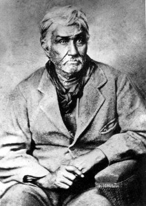
Black Beaver or Se-ket-tu-may-qua was a trapper and interpreter who worked for the American Fur Company. He served as a scout and guide as he was fluent in English, as well as several European and Native American languages. He is credited with establishing the California and Chisholm trails.
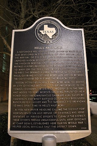
Hell's Half Acre was a precinct of Fort Worth, Texas designated as a red-light district beginning in the early to mid 1870s in the Old Wild West. It came to be called the town's "Bloody Third ward" because of the violence and lawlessness in the area.
Comanche Springs was an aquifer of six artesian springs geographically located between the Edwards Plateau and the Trans-Pecos regions of West Texas. The military fortification Camp Stockton was built around the springs, eventually growing become the city of Fort Stockton.

Blockhouse on Signal Mountain is within the Fort Sill Military Reservation, north of Lawton, Oklahoma. The rock architecture is located along Mackenzie Hill Road within the Fort Sill West Range being the Oklahoma administrative division of Comanche County.
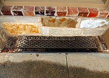 Citizens National Bank cast iron threshold sill at Stonewall Saloon
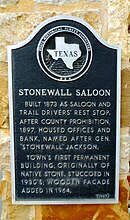 Texas Historical Commission marker at Stonewall Saloon
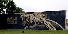 Texas cattlemen mural at Saint Jo, Texas hoedown square


