Tanner Trail

Last updated
Tanner Trail
Tanner Canyon.jpg
A view of Tanner Canyon
Length9 mi (14 km)
Location Grand Canyon National Park, Arizona, United States
Trailheads Lipan Point
Colorado River
Grand Canyon (South Rim)
Use Hiking
Backpacking
Elevation
Elevation change 4,750 ft (1,450 m)
Highest pointLipan Point, 7,400 ft (2,300 m)
Lowest pointColorado River, 2,650 ft (810 m)
Hiking details
Trail difficultyVery strenuous
SeasonEarly Spring to
Late Fall
SightsGrand Canyon
Colorado River
Hazards Severe weather
Overexertion
Dehydration
Flash flood

The Tanner Trail is a hiking trail located on the South Rim of the Grand Canyon National Park, located in the U.S. state of Arizona. The trailhead is located at Lipan Point, a prominent lookout located to the east of the Grand Canyon Village, and the trail ends at the Colorado River at Tanner Rapids. [1]

Contents

History

The Tanner Trail started out as an ancient Anasazi and Hopi route to the Colorado River. Most believe today that Tanner Canyon is where García López de Cárdenas became the first European to encounter the Grand Canyon. The trail is named after Seth Tanner, a 19th-century prospector who improved the trail so he would have better access to his copper mine. It is also believed that Tanner Canyon was once used as an old horse thief trail where buried gold known as Long Tom's treasure is located. The horse thieves would use the canyon to bring the horses from Arizona into Utah. While in the canyon, the horse thieves would change the brands of the horses, then they would cross the Colorado River and drive the horses out of the canyon through the Nankoweap Trail up onto the North Rim. The canyon was once named Horsethief Canyon in honor of this storied past. [2]

Access

Entrance to the South Rim of the Grand Canyon can be accessed by two points: the south entrance via State Route 64 north from Williams, and the east entrance via State Route 64 west from U.S. Route 89. The trailhead for the Tanner Trail is located near the parking area at Lipan Point, which can be accessed by the Desert View Drive. Hikers are advised to park at Lipan Point, as the trailhead is located just before the parking lot at Lipan Point. [3]

Description

The Desert View Watchtower from the Tanner Trail. The Watchtower2.jpg
The Desert View Watchtower from the Tanner Trail.
The Colorado River from the Tanner Trail. Colorado River GC.jpg
The Colorado River from the Tanner Trail.

The Tanner trailhead begins at the information sign just before Lipan Point. The trail starts out by crossing the rim plateau to the canyon edge. It then enters the Tanner Canyon and starts a series of switchbacks, which become very steep and rocky. The descent is considered to be one of the steepest rim descents in the Grand Canyon. The trail goes through the Kaibab Formation and becomes even steeper in the Coconino sandstone and the Hermit shale. It finally reaches the Supai group, where the ridge between Tanner Canyon and Seventyfive Mile Canyon is located.

The trail then enters into the Tanner Canyon creek for a short time, then it leaves the creek. It then makes a long yet moderate crossing of the Supai group. There are many suitable campsites along this stretch, while it passes Escalante and then Cardenas Buttes. The trail passes below these buttes and descends into a boulder-strewn plateau. It then turns to the north to the end of the plateau.

At this point the trail makes its second major descent, dropping off the plateau into the lower Tanner Canyon. There are some switchbacks yet the trail mainly descends straight down around 800 ft (240 m) to a red saddle below where there are a few campsites. From the saddle, the trail levels out, although there is still a gradual rate of descent. The trail follows the west side of Tanner Canyon, slowly descending to the streambed below. When the streambed is reached, the trail crosses over to the east side and up onto the river plateau. It crosses this small plateau and drops into the campground. Campsites can be found to the east and the west [4] :79–86

Mileages and features along the Tanner Trail [4]
Distance (mi)Elv (ft)LocationTrail Junction
07400Lipan Point, South RimTrailhead
1.9566075 Mile SaddleNone
3.55700Below Cardenas ButteNone
92650Tanner Campgrounds Beamer Trail
Escalante Route

Condition

The trail is categorized as a primitive trail and receives little maintenance by trail crews and very few patrols by park rangers. This trail is only recommended for seasoned hikers, as it is very steep, rocky, has very little shade, and the only water source is the Colorado River. The trail is fairly well worn, and mostly easy to follow, although it is one of the longer trails in the Canyon. Extreme care and preparation should always be taken in attempting a trail in the Grand Canyon. [4] :79

Water availability

The only reliable source of water along the Tanner Trail is the Colorado River. Seasonal water may be found in the Tanner Canyon. Hikers can check with the Backcountry Information Center for updates on all seasonal water sources, which are regularly checked by other hikers and Park rangers. All water in the Grand Canyon must be treated before consumption. The National Park Service recommends boiling, iodine tablets, or filters in order to purify the water. If water is taken from the Colorado River, the Park recommends letting the water sit so the sediment will settle. [5]

Camping

Camping in the Tanner Trail area is at-large. There are multiple "campsites" along the trail, but the main camp area is located at Tanner Rapids, a spot that is popular to rafters. The camp area is located at the end of the Trail, situated between the dunes to west and the river to the east. The camp area has a pit toilet located in the middle of the campsites. The sand dunes to west are off-limits to camping and foot-travel, as the Park is attempting to revegetate and stabilize the area . [4] :85

Overnight camping areas along Tanner Trail. [4]
AreaNameTypeGroup(s)PartiesMax People
BB9Tanner RapidsPrimitive1and329

Hazards

Hike-smart 1.gif

Hazards hikers can encounter along the Tanner Trail include dehydration, heat stroke, exhaustion, sudden rainstorms, flash flooding, loose footing, rockfall, encounters with wildlife, extreme heat, and getting lost. At the Colorado River, additional hazards include hypothermia (due to the river's consistently cold temperatures), trauma (due to collisions with boulders in rapids), and drowning. Extreme care, caution, and preparation should always be used when entering the Grand Canyon. [6]

Hikers also need to remember that the Grand Canyon is located in the desert, and as such there are many dangerous desert species to watch out for. These include all types of scorpions, snakes, spiders, centipedes, mice, deer, big horn sheep, and mountain lions. The most dangerous and venomous of these animals are the black widow spider, the Arizona bark scorpion, and the rattlesnake. [4] :44–45

See also

Related Research Articles

Grand Canyon Steep-sided canyon carved by the Colorado River in Arizona, United States

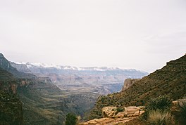
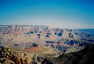
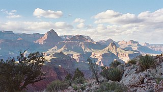
The Grand Canyon is a steep-sided canyon carved by the Colorado River in Arizona, United States. The Grand Canyon is 277 miles (446 km) long, up to 18 miles (29 km) wide and attains a depth of over a mile.

Colorado National Monument National Park Service unit in Colorado, United States

Colorado National Monument is a National Park Service unit near the city of Grand Junction, Colorado. Sheer-walled canyons cut deep into sandstone and granite–gneiss–schist rock formations. This is an area of desert land high on the Colorado Plateau, with pinyon and juniper forests on the plateau. The park hosts a wide range of wildlife, including red-tailed hawks, golden eagles, ravens, jays, desert bighorn sheep, and coyotes. Activities include hiking, horseback riding, road bicycling, and scenic drives; a visitor center on the west side contains a natural history museum and gift shop. There are scenic views from trails, Rim Rock Drive, which winds along the plateau, and the campground. Nearby are the Book Cliffs and the largest flat-topped mountain in the world, the Grand Mesa.

South Kaibab Trail Grand Canyon hiking trail

The South Kaibab Trail is a hiking trail in Grand Canyon National Park, located in the U.S. state of Arizona. Unlike the Bright Angel Trail which also begins at the south rim of the Grand Canyon and leads to the Colorado River, the South Kaibab Trail follows a ridge out to Skeleton Point allowing for 360-degree views of the canyon.

Bright Angel Trail Grand Canyon hiking trail

The Bright Angel Trail is a hiking trail located in Grand Canyon National Park in the U.S. state of Arizona.

Curecanti National Recreation Area

Curecanti National Recreation Area(Pronounced or .) is a National Park Service unit located on the Gunnison River in western Colorado. Established in 1965, Curecanti National Recreation Area is responsible for developing and managing recreational facilities on three reservoirs, Blue Mesa Reservoir, Morrow Point Reservoir and Crystal Reservoir, constructed on the upper Gunnison River in the 1960s by the U.S. Bureau of Reclamation to better utilize the vital waters of the Colorado River and its major tributaries. A popular destination for boating and fishing, Curecanti offers visitors two marinas, traditional and group campgrounds, hiking trails, boat launches, and boat-in campsites. The state's premiere lake trout and Kokanee salmon fisheries, Curecanti is a popular destination for boating and fishing, and is also a popular area for ice-fishing in the winter months.

North Kaibab Trail Grand Canyon hiking trail

The North Kaibab Trail is a hiking trail in the North Rim side of the Grand Canyon, in Grand Canyon National Park, located in the U.S. state of Arizona.

Hermit Trail Grand Canyon hiking trail

The Hermit Trail is a hiking trail in Grand Canyon National Park, located in the U.S. state of Arizona. This trail provides access to a historic area of Grand Canyon and offers a more challenging route to the Colorado River for more experienced canyon hikers.

Cape Final Trail Grand Canyon hiking trail

The Cape Final Trail is a hiking trail on the North Rim of the Grand Canyon National Park, located in the U.S. state of Arizona.

Tonto Trail Grand Canyon hiking trail

The Tonto Trail is a hiking trail on the South Rim of the Grand Canyon in Grand Canyon National Park, located in the U.S. state of Arizona.

Beamer Trail Backpacking trail in Grand Canyon National Park

The Beamer Trail is a backpacking trail located on the South Rim of the Grand Canyon National Park, located in the U.S. state of Arizona.

Boucher Trail Grand Canyon hiking trail

The Boucher Trail is a hiking trail of the South Rim in Grand Canyon National Park, located in the U.S. state of Arizona.

Grandview Trail Grand Canyon hiking trail

The Grandview Trail is a hiking trail located on the South Rim of the Grand Canyon National Park, located in the U.S. state of Arizona.It was built in 1893 by miners and is noted for its cobblestone and cribbing sections.

Nankoweap Trail Grand Canyon hiking trail

The Nankoweap Trail is an unmaintained hiking trail on the North Rim of the Grand Canyon National Park, located in the U.S. state of Arizona. The Nankoweap trail descends 6,040 feet in 14 miles from the Saddle Mountain trailhead to Nankoweap Creek and on to the Colorado River. It is considered to be the hardest of the trails into the Canyon. Hikers have to carry and cache water as there is none in the 11 miles between the trailhead and Nankoweap Creek.

New Hance Trail Grand Canyon hiking trail

The New Hance Trail is a hiking trail on the South Rim of the Grand Canyon National Park, located in the U.S. state of Arizona. It is one of the "unmaintained" trails and, along with the similar Tanner Trail, is considered one of the most difficult trails on the South Rim. Unlike the Tanner Trail, there is no parking available at the trailhead, which is located about a 5-minute walk north of the South Rim main road. The trail ends at the Hance Rapids on the Colorado River. It is approximately 6.5 hiking miles and a 4400' descent from the South Rim main road at ~7040' to the Colorado River at ~2600' elevation.

Tuckup Trail Grand Canyon hiking trail

The Tuckup Trail is a 100-mile-long (160 km) hiking trail on the North Rim of the Grand Canyon, in Grand Canyon National Park, located in the U.S. state of Arizona.

Coyote Gulch

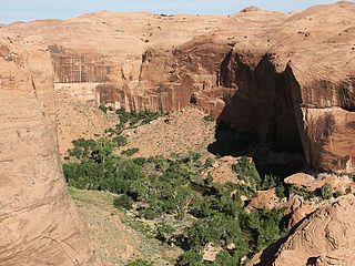
Coyote Gulch is a tributary of the Escalante River, located in Garfield and Kane Counties in southern Utah, in the western United States. Over 25 mi (40 km) long, Coyote Gulch exhibits many of the geologic features found in the Canyons of the Escalante, including high vertical canyon walls, narrow slot canyons, domes, arches, and natural bridges. The upper sections of Coyote Gulch are located within the Grand Staircase-Escalante National Monument while its lower sections are located in the Glen Canyon National Recreation Area.

Havasupai Trail Historic trail in Coconino County, Arizona

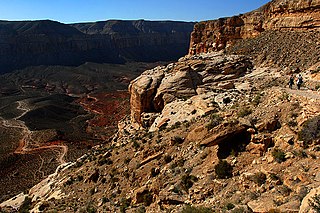
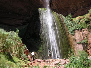
Havasupai Trail is the main trail to Supai, Arizona, and to Havasu Falls. There are other trails, such as the Topocoba, Moqui and Kirby trails. However, these other trails are not maintained. As far back as 1976, they were described as ranging from "in poor repair" to "primitive, dangerous foot trails." Special permission is required to use any such trail.

Temple Butte

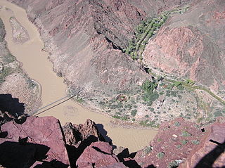
Temple Butte, in the Grand Canyon, Arizona, USA is a prominence below the East Rim. The butte lies on the west bank of the south-flowing Colorado River. The outfall from the Little Colorado River, draining from the Painted Desert to the east and southeast, is about 2-mi upstream.

Toroweap Formation

The Middle Permian Toroweap Formation is a thin, darker geologic unit, between the brighter colored units of the Kaibab Limestone above, and Coconino Sandstone below. It is a prominent unit in Grand Canyon, Arizona, USA, found through sections of the South Rim, Grand Canyon, and the North Rim, of the Kaibab Plateau; also the Kaibab's southeast extension to Cape Royal, the Walhalla Plateau. The Colorado River of the Grand Canyon makes its excursion from due-south to due-west around the Walhalla Plateau, as it enters the east end of the Grand Canyon's interior, Granite Gorge. The formation is also found in southeast Utah.

Tanner Graben

Located directly downstream of the Little Colorado River confluence with the Colorado River, the Tanner Graben, in the Grand Canyon, Arizona, USA is a prominence and cliffside rock formation below the East Rim. Tanner Graben is located riverside, on the Colorado River, on a north-northwest bank at Mile 68.5, and lies opposite Tanner Canyon. The Tanner Rapid, created by Tanner Creek lies at the riverside foot of the graben. The graben is a pronounced feature because of the black Cardenas Basalt that forms the middle section of the graben, presumably free of debris accumulation by its cliff face steepness, and winds, and airflow drainage that course through the Colorado River's canyons; unprotected side canyons of Cardenas Basalt show accumulations as a slope-forming geologic unit, with little showing of black basalt.

References

  1. National Geographic Maps Trails Illustrated:Grand Canyon National Park
  2. History of Tanner Trail
  3. Directions to South Rim
  4. 1 2 3 4 5 6 Adkinson, Ron (2006). A Falcon Guide:Hiking Grand Canyon National Park. Morris Book Publishing. ISBN   0-7627-3657-7.
  5. Hiking FAQ's
  6. Grand Canyon National Park Summer Hiking

Coordinates: 36°02′N111°51′W / 36.04°N 111.85°W / 36.04; -111.85