
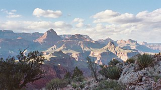
Grand Canyon National Park, located in northwestern Arizona, is the 15th site in the United States to have been named as a national park. The park's central feature is the Grand Canyon, a gorge of the Colorado River, which is often considered one of the Wonders of the World. The park, which covers 1,217,262 acres of unincorporated area in Coconino and Mohave counties, received more than six million recreational visitors in 2017, which is the second highest count of all American national parks after Great Smoky Mountains National Park. The Grand Canyon was designated a World Heritage Site by UNESCO in 1979. The park celebrated its 100th anniversary on February 26, 2019.

The Grand Canyon is a steep-sided canyon carved by the Colorado River in Arizona, United States. The Grand Canyon is 277 miles (446 km) long, up to 18 miles (29 km) wide and attains a depth of over a mile.
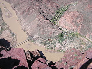
The South Kaibab Trail is a hiking trail in Grand Canyon National Park, located in the U.S. state of Arizona. Unlike the Bright Angel Trail which also begins at the south rim of the Grand Canyon and leads to the Colorado River, the South Kaibab Trail follows a ridge out to Skeleton Point allowing for 360-degree views of the canyon.

The Bright Angel Trail is a hiking trail located in Grand Canyon National Park in the U.S. state of Arizona.

Hermits Rest is a structure built in 1914 at the western end of Hermit Road at the south rim of the Grand Canyon in Arizona, United States. The Hermit Trail, a hiking trail that extends to the Colorado River, begins about ¼ mile beyond the shuttle bus stop at Hermits Rest. Hermits Rest also represents the western terminus of the Rim Trail. The location was named for Louis Boucher. Around 1891, Boucher – a Canadian-born prospector – staked claims below present-day Hermits Rest. With help, Boucher carved the aforementioned trail into the canyon, and for years lived alone at nearby Dripping Springs. The main structure currently standing at Hermits Rest was designed by architect Mary Colter. Hermits Rest is the westernmost point on the canyon's south rim that is accessible by paved road. It was built as a rest area for tourists on coaches operated by the Fred Harvey Company on the way to the now-vanished Hermit Camp. The building was designed to appear to be a natural stone formation, closely tied to the land. Colter selected furnishings that are included in the National Historic Landmark designation.

The Arizona Strip is the part of Arizona lying north of the Colorado River. Despite being larger in area than several U.S. states, the entire region has a population of fewer than 10,000 people. Consisting of northeastern Mohave County and northwestern Coconino County, the largest settlements in the Strip are Colorado City, Fredonia, and Beaver Dam, with smaller communities of Scenic, Littlefield and Desert Springs. The Kaibab Indian Reservation lies within the region. Lying along the North Rim of the Grand Canyon creates physical barriers to the rest of Arizona. Only three major roads traverse the region, I-15 crosses the northwestern corner while Arizona State Route 389 and U.S. Route 89A crosses the northeastern part of the strip, US 89A crosses the Colorado River via the Navajo Bridge, providing the only direct road connection between the strip and the rest of the state. The nearest metropolitan area is the St. George, Utah metro area, to which the region is more connected than to the rest of Arizona.
The North Kaibab Trail is a hiking trail in the North Rim side of the Grand Canyon, in Grand Canyon National Park, located in the U.S. state of Arizona.

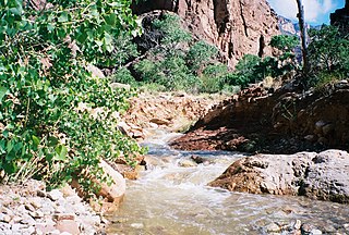
The Hermit Trail is a hiking trail in Grand Canyon National Park, located in the U.S. state of Arizona. This trail provides access to a historic area of Grand Canyon and offers a more challenging route to the Colorado River for more experienced canyon hikers.

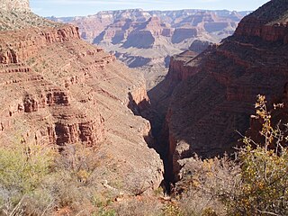
The Tonto Trail is a hiking trail on the South Rim of the Grand Canyon in Grand Canyon National Park, located in the U.S. state of Arizona.

The Bill Hall Trail is a hiking trail in Grand Canyon National Park, located in the U.S. state of Arizona.

The Boucher Trail is a hiking trail of the South Rim in Grand Canyon National Park, located in the U.S. state of Arizona.
The Clear Creek Trail is a hiking trail below the North Rim, from lower Bright Angel Canyon into lower Clear Creek Canyon of the Grand Canyon National Park, located in the U.S. state of Arizona.

The Plateau Point Trail is a hiking and pack trail located on the South Rim of the Grand Canyon National Park, located in the U.S. state of Arizona.
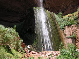
The Dripping Springs Trail is a hiking trail on the South Rim of the Grand Canyon National Park, located in the U.S. state of Arizona.

The Tanner Trail is a hiking trail located on the South Rim of the Grand Canyon National Park, located in the U.S. state of Arizona. The trailhead is located at Lipan Point, a prominent lookout located to the east of the Grand Canyon Village, and the trail ends at the Colorado River at Tanner Rapids.

The North Bass Trail is a hiking trail located on the North Rim of the Grand Canyon, in Grand Canyon National Park, located in the U.S. state of Arizona.
The New Hance Trail is a hiking trail on the South Rim of the Grand Canyon National Park, located in the U.S. state of Arizona. It is one of the "unmaintained" trails and, along with the similar Tanner Trail, is considered one of the most difficult trails on the South Rim. Unlike the Tanner Trail, there is no parking available at the trailhead, which is located about a 5-minute walk north of the South Rim main road. The trail ends at the Hance Rapids on the Colorado River. It is approximately 6.5 hiking miles and a 4400' descent from the South Rim main road at ~7040' to the Colorado River at ~2600' elevation.

Isis Temple is a prominence in the Grand Canyon, Arizona, Southwestern United States. It is located below the North Rim and adjacent to the Granite Gorge along the Colorado River. The Trinity Creek and canyon flow due south at its west border; its north, and northeast border/flank is formed by Phantom Creek and canyon, a west tributary of Bright Angel Creek; the creeks intersect about 3 mi (4.8 km) southeast, and 1.0 mi (1.6 km) north of Granite Gorge. The Isis Temple prominence, is only about 202 ft (62 m) lower than Grand Canyon Village, the main public center on Grand Canyon’s South Rim.

Located directly downstream of the Little Colorado River confluence with the Colorado River, the Tanner Graben, in the Grand Canyon, Arizona, US is a prominence and cliffside rock formation below the East Rim. Tanner Graben is located riverside, on the Colorado River, on a north-northwest bank at Mile 68.5, and lies opposite Tanner Canyon. The Tanner Rapid, created by Tanner Creek lies at the riverside foot of the graben. The graben is a pronounced feature because of the black Cardenas Basalt that forms the middle section of the graben, presumably free of debris accumulation by its cliff face steepness, and winds, and airflow drainage that course through the Colorado River's canyons; unprotected side canyons of Cardenas Basalt show accumulations as a slope-forming geologic unit, with little showing of black basalt.

Toroweap Overlook is a viewpoint within the Grand Canyon National Park in Arizona, United States. It is located in a remote area on the North Rim of the Grand Canyon, 55 miles (89 km) west of the North Rim Headquarters. The overlook is the only viewpoint in the National Park from where the Colorado River can be seen vertically below. The overlook stands 3,000 feet (910 m) above the river.

