The South Kaibab Trail is a hiking trail in Grand Canyon National Park, located in the U.S. state of Arizona. Unlike the Bright Angel Trail which also begins at the south rim of the Grand Canyon and leads to the Colorado River, the South Kaibab Trail follows a ridge out to Skeleton Point allowing for 360-degree views of the canyon.

The Arizona Strip is the part of Arizona lying north of the Colorado River. Despite being larger in area than several U.S. states, the entire region has a population of fewer than 10,000 people. Consisting of northeastern Mohave County and northwestern Coconino County, the largest settlements in the Strip are Colorado City, Fredonia, and Beaver Dam, with smaller communities of Scenic, Littlefield and Desert Springs. The Kaibab Indian Reservation lies within the region. Lying along the North Rim of the Grand Canyon creates physical barriers to the rest of Arizona. Only three major roads traverse the region, I-15 crosses the northwestern corner while Arizona State Route 389 and U.S. Route 89A crosses the northeastern part of the strip, US 89A crosses the Colorado River via the Navajo Bridge, providing the only direct road connection between the strip and the rest of the state. The nearest metropolitan area is the St. George, Utah metro area, to which the region is more connected than to the rest of Arizona.
The North Kaibab Trail is a hiking trail in the North Rim side of the Grand Canyon, in Grand Canyon National Park, located in the U.S. state of Arizona.

The Hermit Trail is a hiking trail in Grand Canyon National Park, located in the U.S. state of Arizona. This trail provides access to a historic area of Grand Canyon and offers a more challenging route to the Colorado River for more experienced canyon hikers.

The Cape Final Trail is a hiking trail on the North Rim of the Grand Canyon National Park, located in the U.S. state of Arizona.

The Tonto Trail is a hiking trail on the South Rim of the Grand Canyon in Grand Canyon National Park, located in the U.S. state of Arizona.

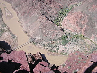
The River Trail is a hiking trail in Grand Canyon National Park, located in the U.S. state of Arizona. This trail connects the end of the Bright Angel Trail with Phantom Ranch and the South Kaibab Trail.

The Bill Hall Trail is a hiking trail in Grand Canyon National Park, located in the U.S. state of Arizona.
The Clear Creek Trail is a hiking trail below the North Rim, from lower Bright Angel Canyon into lower Clear Creek Canyon of the Grand Canyon National Park, located in the U.S. state of Arizona.

The Bright Angel Point Trail is a hiking trail located on the North Rim of the Grand Canyon National Park, located in the U.S. state of Arizona.

The Plateau Point Trail is a hiking and pack trail located on the South Rim of the Grand Canyon National Park, located in the U.S. state of Arizona.
The Dripping Springs Trail is a hiking trail on the South Rim of the Grand Canyon National Park, located in the U.S. state of Arizona.

The Cape Royal Trail is a hiking trail on the North Rim of the Grand Canyon National Park, located in the U.S. state of Arizona.

The Tanner Trail is a hiking trail located on the South Rim of the Grand Canyon National Park, located in the U.S. state of Arizona. The trailhead is located at Lipan Point, a prominent lookout located to the east of the Grand Canyon Village, and the trail ends at the Colorado River at Tanner Rapids.

The North Bass Trail is a hiking trail located on the North Rim of the Grand Canyon, in Grand Canyon National Park, located in the U.S. state of Arizona.

The South Bass Trail is a hiking trail located on the South Rim of the Grand Canyon National Park, located in the U.S. state of Arizona.
The Thunder River Trail is a hiking trail on the North Rim of the Grand Canyon National Park, located in the U.S. state of Arizona.

The Escalante Route is a hiking trail on the South Rim of the Grand Canyon National Park, located in the U.S. state of Arizona. It starts near the Tanner Rapids on the Colorado River and follows the river. It also passes by Escalante Creek and ends near the Hance Rapids. It falls into the lowest maintenance category ("route") of the Grand Canyon trails which means it is essentially unmaintained. There is a 30-feet cliff located near the Hance Rapids, popularly known as the Papago Wall, which needs to be climbed. The National Park Service advises to bring a rope for backpacks. There are several other easy, yet avoidable climbing opportunities in 75 Mile Canyon, some of which have been marked by cairns.

The Tuckup Trail is a 100-mile-long (160 km) hiking trail on the North Rim of the Grand Canyon, in Grand Canyon National Park, located in the U.S. state of Arizona.
This page is based on this
Wikipedia article Text is available under the
CC BY-SA 4.0 license; additional terms may apply.
Images, videos and audio are available under their respective licenses.

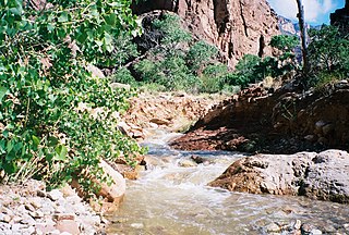
 A side canyon/drainage where part of the Royal Arch Route is located.
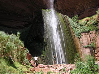
 The location of the start of the west Tonto Trail and the end of the Royal Arch Route along the Colorado River.
