
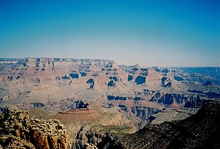
Grand Canyon National Park, located in northwestern Arizona, is the 15th site in the United States to have been named as a national park. The park's central feature is the Grand Canyon, a gorge of the Colorado River, which is often considered one of the Wonders of the World. The park, which covers 1,217,262 acres of unincorporated area in Coconino and Mohave counties, received more than six million recreational visitors in 2017, which is the second highest count of all American national parks after Great Smoky Mountains National Park. The Grand Canyon was designated a World Heritage Site by UNESCO in 1979. The park celebrated its 100th anniversary on February 26, 2019.
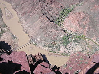
The South Kaibab Trail is a hiking trail in Grand Canyon National Park, located in the U.S. state of Arizona. Unlike the Bright Angel Trail which also begins at the south rim of the Grand Canyon and leads to the Colorado River, the South Kaibab Trail follows a ridge out to Skeleton Point allowing for 360-degree views of the canyon.

The Bright Angel Trail is a hiking trail located in Grand Canyon National Park in the U.S. state of Arizona.

Curecanti National Recreation Area(Pronounced or .) is a National Park Service unit located on the Gunnison River in western Colorado. Established in 1965, Curecanti National Recreation Area is responsible for developing and managing recreational facilities on three reservoirs, Blue Mesa Reservoir, Morrow Point Reservoir and Crystal Reservoir, constructed on the upper Gunnison River in the 1960s by the U.S. Bureau of Reclamation to better utilize the vital waters of the Colorado River and its major tributaries. A popular destination for boating and fishing, Curecanti offers visitors two marinas, traditional and group campgrounds, hiking trails, boat launches, and boat-in campsites. The state's premiere lake trout and Kokanee salmon fisheries, Curecanti is a popular destination for boating and fishing, and is also a popular area for ice-fishing in the winter months.

Hermits Rest is a structure built in 1914 at the western end of Hermit Road at the south rim of the Grand Canyon in Arizona, United States. The Hermit Trail, a hiking trail that extends to the Colorado River, begins about ¼ mile beyond the shuttle bus stop at Hermits Rest. Hermits Rest also represents the western terminus of the Rim Trail. The location was named for Louis Boucher. Around 1891, Boucher – a Canadian-born prospector – staked claims below present-day Hermits Rest. With help, Boucher carved the aforementioned trail into the canyon, and for years lived alone at nearby Dripping Springs. The main structure currently standing at Hermits Rest was designed by architect Mary Colter. Hermits Rest is the westernmost point on the canyon's south rim that is accessible by paved road. It was built as a rest area for tourists on coaches operated by the Fred Harvey Company on the way to the now-vanished Hermit Camp. The building was designed to appear to be a natural stone formation, closely tied to the land. Colter selected furnishings that are included in the National Historic Landmark designation.
The North Kaibab Trail is a hiking trail in the North Rim side of the Grand Canyon, in Grand Canyon National Park, located in the U.S. state of Arizona.

The Hermit Trail is a hiking trail in Grand Canyon National Park, located in the U.S. state of Arizona. This trail provides access to a historic area of Grand Canyon and offers a more challenging route to the Colorado River for more experienced canyon hikers.

The Cape Final Trail is a hiking trail on the North Rim of the Grand Canyon National Park, located in the U.S. state of Arizona.

The Tonto Trail is a hiking trail on the South Rim of the Grand Canyon in Grand Canyon National Park, located in the U.S. state of Arizona.

The Bill Hall Trail is a hiking trail in Grand Canyon National Park, located in the U.S. state of Arizona.

The Boucher Trail is a hiking trail of the South Rim in Grand Canyon National Park, located in the U.S. state of Arizona.
The Clear Creek Trail is a hiking trail below the North Rim, from lower Bright Angel Canyon into lower Clear Creek Canyon of the Grand Canyon National Park, located in the U.S. state of Arizona.

The Bright Angel Point Trail is a hiking trail located on the North Rim of the Grand Canyon National Park, located in the U.S. state of Arizona.

The Plateau Point Trail is a hiking and pack trail located on the South Rim of the Grand Canyon National Park, located in the U.S. state of Arizona.
The Grandview Trail is a hiking trail located on the South Rim of the Grand Canyon National Park, located in the U.S. state of Arizona.It was built in 1893 by miners and is noted for its cobblestone and cribbing sections.

The Tanner Trail is a hiking trail located on the South Rim of the Grand Canyon National Park, located in the U.S. state of Arizona. The trailhead is located at Lipan Point, a prominent lookout located to the east of the Grand Canyon Village, and the trail ends at the Colorado River at Tanner Rapids.

The North Bass Trail is a hiking trail located on the North Rim of the Grand Canyon, in Grand Canyon National Park, located in the U.S. state of Arizona.

The South Bass Trail is a hiking trail located on the South Rim of the Grand Canyon National Park, located in the U.S. state of Arizona.

Cocopa Point is a 6,627 foot (2,020 m)-cliff-elevation Point located in the central,, Grand Canyon, Coconino County of northern Arizona, United States. Cocopa Point is 1.1 miles from its closest highest scenic viewpoint, Yuma Point (6,654 ft), located east at Eremita Mesa, at the northeast, overlooking Central Hermit Canyon.
Cocopa Point is in a region of points, at the headwaters of canyons, and landforms below the South Rim. Mimbreno Point lies ~1.7 miles west, and Hermit Canyon and Pima Point, at the west-terminus of West Rim Drive, are about 1.5 mi and 2.0 miles due-east. Cocopa Point is at the northwest of Eremita Mesa; Yuma Point is at the northeast; the mesa lies between Hermit Canyon, east, and Upper Boucher Canyon, west. Cocopa Point is a sheer-walled cliff, sitting at the northwest headwaters of short, Travertine Canyon. At the west of Lower Travertine Canyon, adjacent the Colorado River, sits Whites Butte, about 1.2 miles distant from Cocopa Point.

Hermit Canyon is a north-trending canyon in western Grand Canyon, about 6.0 miles in length, below the South Rim. It is named for the Hermit who built Hermit Camp, at the Colorado River, Louis D. Boucher. Hermit Canyon's east flank is bordered by Pima Point of the South Rim, and Pima Point is ~2.0 from the Hermit Canyon midline. Pima Point is about 3.5 miles west-northwest of Grand Canyon Village, and the South Rim at Pima Point trends southward, as the start of Western Grand Canyon; it also marks the terminus of the West Rim Road.
