Beamer Trail

Last updated
Beamer Trail

Beamer Trail.jpg

Hikers walking along the Beamer Trail, with the Colorado River in the distance.
Location Grand Canyon National Park, Arizona, United States
Trailheads Colorado River
Use Hiking
Hiking details
Sights Grand Canyon
Hazards Severe Weather
Overexertion
Dehydration
Flash Flood

The Beamer Trail is a backpacking trail located on the South Rim of the Grand Canyon National Park, located in the U.S. state of Arizona. [1]

Backpacking (wilderness) outdoor recreation of carrying gear on ones back, while hiking for more than a day. It is often but not always an extended journey, and may or may not involve camping outdoors

Backpacking is the outdoor recreation of carrying gear on one's back, while hiking for more than a day. It is often but not always an extended journey, and may or may not involve camping outdoors. In North America tenting is common, where simple shelters and mountain huts widely found in Europe are rare. In New Zealand, tramping is the term applied though overnight huts are frequently used. Hill walking is an equivalent in Britain, though backpackers make use of all kinds of accommodation, in addition to camping. Backpackers use simple huts in South Africa. Similar terms used in other countries are trekking and bushwalking.

Trail path with a rough beaten or dirt/stone surface used for travel

A trail is usually a path, track or unpaved lane or road. In the United Kingdom and the Republic of Ireland path or footpath is the preferred term for a walking trail. The term is also applied, in North America, to routes along rivers, and sometimes to highways. In the US, the term was historically used for a route into or through wild territory used by emigrants. In the USA "trace" is a synonym for trail, as in Natchez Trace. Some trails are single use and can only be used for walking, cycling, horse riding, snowshoeing, and cross-country skiing; others, as in the case of a bridleway in the UK, are multi-use, and can be used by walkers, cyclists and equestrians. There are also unpaved trails used by dirt bikes and other off-road vehicles and in some places, like the Alps, trails are used for moving cattle and other livestock.

Grand Canyon National Park national park of the United States in Arizona

Grand Canyon National Park, located in northwestern Arizona, is the 15th site in the United States to have been named a national park. The park's central feature is the Grand Canyon, a gorge of the Colorado River, which is often considered one of the Wonders of the World. The park, which covers 1,217,262 acres of unincorporated area in Coconino and Mohave counties, received more than six million recreational visitors in 2017, which is the second highest count of all American national parks after Great Smoky Mountains National Park. The Grand Canyon was designated a World Heritage Site by UNESCO in 1979.

Contents

Description

The trail begins at the end of the Tanner Trail, at the confluence of Tanner Creek and the Colorado River. This confluence created the Unkar Creek Rapids. From here the trail follows the Colorado north (upstream) to its confluence with the Little Colorado River. The trail is considered primitive, and some route finding is required. To the east of the trail is the Palisades of the Desert, a two-thousand foot cliff that showcases the upper portion of the canyon's rock layers.

Tanner Trail hiking trail in Arizona

The Tanner Trail is a hiking trail located on the South Rim of the Grand Canyon National Park, located in the U.S. state of Arizona. The trailhead is located at Lipan Point, a prominent lookout located to the east of the Grand Canyon Village and it ends at the Colorado River at Tanner Rapids.

Colorado River major river in the western United States and Mexico

The Colorado River is one of the principal rivers in the Southwestern United States and northern Mexico. The 1,450-mile-long (2,330 km) river drains an expansive, arid watershed that encompasses parts of seven U.S. and two Mexican states. Starting in the central Rocky Mountains of Colorado, the river flows generally southwest across the Colorado Plateau and through the Grand Canyon before reaching Lake Mead on the Arizona–Nevada border, where it turns south toward the international border. After entering Mexico, the Colorado approaches the mostly dry Colorado River Delta at the tip of the Gulf of California between Baja California and Sonora.

Little Colorado River river in the United States of America

The Little Colorado River is a tributary of the Colorado River in the U.S. state of Arizona, providing the principal drainage from the Painted Desert region. Together with its major tributary, the Puerco River, it drains an area of about 26,500 square miles (69,000 km2) in eastern Arizona and western New Mexico. Although it stretches almost 340 miles (550 km), only the headwaters and the lowermost reaches flow year-round. Between St. Johns and Cameron, most of the river is a wide, braided wash, only containing water after heavy snowmelt or flash flooding.

Camping is not allowed within a ½ mile of the confluence of the Colorado River and the Little Colorado River. Elsewhere along the trail, at-large camping is allowed by permit only from the park's Backcountry Information Center.

See also

Related Research Articles

South Kaibab Trail geographical object

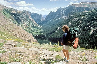
The South Kaibab Trail is a hiking trail in Grand Canyon National Park, located in the U.S. state of Arizona. Unlike the Bright Angel Trail which also begins at the south rim of the Grand Canyon and leads to the Colorado River, the South Kaibab Trail follows a ridge out to Skeleton Point allowing for 360-degree views of the canyon.

Bright Angel Trail

The Bright Angel Trail is a hiking trail located in Grand Canyon National Park in the U.S. state of Arizona.

Phantom Ranch

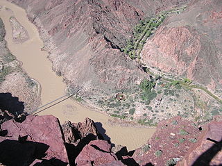
Phantom Ranch is a lodge inside Grand Canyon National Park in Arizona. It is on the north side of the Colorado River near its confluence with Bright Angel Creek and Phantom Creek. Built in 1922, Phantom Ranch is a member of Historic Hotels of America, the official program of the National Trust for Historic Preservation.

North Kaibab Trail

The North Kaibab Trail is a hiking trail in the North Rim side of the Grand Canyon, in Grand Canyon National Park, located in the U.S. state of Arizona.

Hermit Trail

The Hermit Trail is a hiking trail in Grand Canyon National Park, located in the U.S. state of Arizona. This trail provides access to a historic area of Grand Canyon and offers a more challenging route to the Colorado River for more experienced canyon hikers.

Cape Final Trail

The Cape Final Trail is a hiking trail on the North Rim of the Grand Canyon National Park, located in the U.S. state of Arizona.

Tonto Trail

The Tonto Trail is a hiking trail on the South Rim of the Grand Canyon in Grand Canyon National Park, located in the U.S. state of Arizona.

River Trail (Arizona)

The River Trail is a hiking trail in Grand Canyon National Park, located in the U.S. state of Arizona. This trail connects the end of the Bright Angel Trail with Phantom Ranch and the South Kaibab Trail.

Boucher Trail

The Boucher Trail is a hiking trail of the South Rim in Grand Canyon National Park, located in the U.S. state of Arizona.

Clear Creek Trail

The Clear Creek Trail is a hiking trail on the North Rim of the Grand Canyon National Park, located in the U.S. state of Arizona.

Grandview Trail

The Grandview Trail is a hiking trail located on the South Rim of the Grand Canyon National Park, located in the U.S. state of Arizona.

North Bass Trail

The North Bass Trail is a hiking trail located on the North Rim of the Grand Canyon, in Grand Canyon National Park, located in the U.S. state of Arizona.

Nankoweap Trail

The Nankoweap Trail is an unmaintained hiking trail on the North Rim of the Grand Canyon National Park, located in the U.S. state of Arizona. The Nankoweap trail descends 6,040 feet in 14 miles from the Saddle Mountain trailhead to Nankoweap Creek and on to the Colorado River. It is considered to be the hardest of the trails into the Canyon. Hikers have to carry and cache water as there is none in the 11 miles between the trailhead and Nankoweap Creek.

New Hance Trail

The New Hance Trail is a hiking trail on the South Rim of the Grand Canyon National Park, located in the U.S. state of Arizona. It is one of the "unmaintained" trails and, along with the similar Tanner Trail, is considered one of the most difficult trails on the South Rim. Unlike the Tanner Trail, there is no parking available at the trailhead, which is located about a 5-minute walk north of the South Rim main road. The trail ends at the Hance Rapids on the Colorado River. It is approximately 6.5 hiking miles and a 4400' descent from the South Rim main road at ~7040' to the Colorado River at ~2600' elevation.

Escalante Route

The Escalante Route is a hiking trail on the South Rim of the Grand Canyon National Park, located in the U.S. state of Arizona. It starts near the Tanner Rapids on the Colorado River and follows the river. It also passes by Escalante Creek and ends near the Hance Rapids. It falls into the lowest maintenance category ("route") of the Grand Canyon trails which means it is essentially unmaintained. There is an unavoidable 30-feet cliff located near the Hance Rapids which need to be climbed. The National Park Service advises to bring a rope for backpacks. There are several other easy, yet avoidable climbing opportunities in 75 Mile Canyon, some of which have been marked by cairns.

The South Canyon Trail is a hiking trail located on the North Rim of the Grand Canyon National Park, located in the U.S. state of Arizona. It follows Marble Canyon’s longest tributary gorge to the Colorado River.

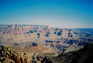
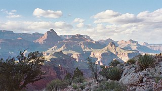
The Grand Canyon National Park is a U.S. National Park located in the state of Arizona. The Park encompasses the Grand Canyon and the surrounding rim areas. The Park maintains an intricate trail system both above and below the rims of the canyon. To properly maintain and supervise the many trails and campgrounds in the backcountry of the Grand Canyon, Park implemented a system of zoning the different areas of the canyon and the surrounding rim area into backcountry "use areas," designated by a two-letter, one-number code system.

Tanner Graben mountain in United States of America

Located directly downstream of the Little Colorado River confluence with the Colorado River, the Tanner Graben, in the Grand Canyon, Arizona, USA is a prominence and cliffside rock formation below the East Rim. Tanner Graben is located riverside, on the Colorado River, on a north-northwest bank at Mile 68.5, and lies opposite Tanner Canyon. The Tanner Rapid, created by Tanner Creek lies at the riverside foot of the graben. The graben is a pronounced feature because of the black Cardenas Basalt that forms the middle section of the graben, presumably free of debris accumulation by its cliff face steepness, and winds, and airflow drainage that course through the Colorado River's canyons; unprotected side canyons of Cardenas Basalt show accumulations as a slope-forming geologic unit, with little showing of black basalt.

Grand Canyon Escalade

The Grand Canyon Escalade was a proposed entertainment complex on the eastern rim of the Grand Canyon within the boundaries of the Navajo Nation.

References

  1. Dollar, Tom; Sieve, Jerry (1999). Guide to Arizona's Wilderness Areas. Big Earth Publishing. ISBN   1-56579-280-7.

Coordinates: 36°06′06″N111°49′50″W / 36.10173°N 111.83055°W / 36.10173; -111.83055

Geographic coordinate system Coordinate system

A geographic coordinate system is a coordinate system that enables every location on Earth to be specified by a set of numbers, letters or symbols. The coordinates are often chosen such that one of the numbers represents a vertical position and two or three of the numbers represent a horizontal position; alternatively, a geographic position may be expressed in a combined three-dimensional Cartesian vector. A common choice of coordinates is latitude, longitude and elevation. To specify a location on a plane requires a map projection.