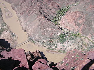
The South Kaibab Trail is a hiking trail in Grand Canyon National Park, located in the U.S. state of Arizona. Unlike the Bright Angel Trail which also begins at the south rim of the Grand Canyon and leads to the Colorado River, the South Kaibab Trail follows a ridge out to Skeleton Point allowing for 360-degree views of the canyon.

The Bright Angel Trail is a hiking trail located in Grand Canyon National Park in the U.S. state of Arizona.

Horseshoe Bend is a horseshoe-shaped incised meander of the Colorado River located near the town of Page, Arizona, United States. It is also referred to as the "east rim of the Grand Canyon."
The North Kaibab Trail is a hiking trail in the North Rim side of the Grand Canyon, in Grand Canyon National Park, located in the U.S. state of Arizona.

The Hermit Trail is a hiking trail in Grand Canyon National Park, located in the U.S. state of Arizona. This trail provides access to a historic area of Grand Canyon and offers a more challenging route to the Colorado River for more experienced canyon hikers.

The Tonto Trail is a hiking trail on the South Rim of the Grand Canyon in Grand Canyon National Park, located in the U.S. state of Arizona.

The Beamer Trail is a backpacking trail located on the South Rim of the Grand Canyon National Park, located in the U.S. state of Arizona.
The Grandview Trail is a hiking trail located on the South Rim of the Grand Canyon National Park, located in the U.S. state of Arizona.It was built in 1893 by miners and is noted for its cobblestone and cribbing sections.

The Tanner Trail is a hiking trail located on the South Rim of the Grand Canyon National Park, located in the U.S. state of Arizona. The trailhead is located at Lipan Point, a prominent lookout located to the east of the Grand Canyon Village, and the trail ends at the Colorado River at Tanner Rapids.

The Nankoweap Trail is an unmaintained hiking trail on the North Rim of the Grand Canyon National Park, located in the U.S. state of Arizona. The Nankoweap trail descends 6,040 feet in 14 miles from the Saddle Mountain trailhead to Nankoweap Creek and on to the Colorado River. It is considered to be the hardest of the trails into the Canyon. Hikers have to carry and cache water as there is none in the 11 miles between the trailhead and Nankoweap Creek.
The New Hance Trail is a hiking trail on the South Rim of the Grand Canyon National Park, located in the U.S. state of Arizona. It is one of the "unmaintained" trails and, along with the similar Tanner Trail, is considered one of the most difficult trails on the South Rim. Unlike the Tanner Trail, there is no parking available at the trailhead, which is located about a 5-minute walk north of the South Rim main road. The trail ends at the Hance Rapids on the Colorado River. It is approximately 6.5 hiking miles and a 4400' descent from the South Rim main road at ~7040' to the Colorado River at ~2600' elevation.

The Tuckup Trail is a 100-mile-long (160 km) hiking trail on the North Rim of the Grand Canyon, in Grand Canyon National Park, located in the U.S. state of Arizona.

The San Juan Expedition was a group of Mormon settlers intent on establishing a colony in what is now southeastern Utah, in the western United States. Their difficult passage through the deep canyons of the Colorado River represents the ingenuity and determination needed during the country's era of western exploration and settlement.

The Canyons of the Escalante is a collective name for the erosional landforms created by the Escalante River and its tributaries—the Escalante River Basin. Located in southern Utah in the western United States, these sandstone features include high vertical canyon walls, numerous slot canyons, waterpockets, domes, hoodoos, natural arches and bridges. This area—extending over 1,500 square miles (3,885 km2) and rising in elevation from 3,600 ft (1,097 m) to over 11,000 ft (3,353 m)—is one of the three main sections of the Grand Staircase-Escalante National Monument, and also a part of the Glen Canyon National Recreation Area, with Capitol Reef National Park being adjacent to the east.
Harris Wash is a long tributary of the Escalante River located in Garfield County in southern Utah, in the western United States. Over 40 miles (64 km) long with a drainage of 270 square miles (700 km2), it exhibits many of the geologic features found in the Canyons of the Escalante, including high vertical canyon walls and narrow slot canyons. A popular recreational destination and a historic transportation route, it is located within the Grand Staircase-Escalante National Monument.

Located directly downstream of the Little Colorado River confluence with the Colorado River, the Tanner Graben, in the Grand Canyon, Arizona, USA is a prominence and cliffside rock formation below the East Rim. Tanner Graben is located riverside, on the Colorado River, on a north-northwest bank at Mile 68.5, and lies opposite Tanner Canyon. The Tanner Rapid, created by Tanner Creek lies at the riverside foot of the graben. The graben is a pronounced feature because of the black Cardenas Basalt that forms the middle section of the graben, presumably free of debris accumulation by its cliff face steepness, and winds, and airflow drainage that course through the Colorado River's canyons; unprotected side canyons of Cardenas Basalt show accumulations as a slope-forming geologic unit, with little showing of black basalt.

The Hakatai Shale is a Mesoproterozoic rock formation with important exposures in the Grand Canyon, Coconino County, Arizona. It consists of colorful strata that exhibit colors varying from purple to red to brilliant orange. These colors are the result of the oxidation of iron-bearing minerals in the Hakatai Shale. It consists of lower and middle members that consist of bright-red, slope-forming, highly fractured, argillaceous mudstones and shale and an upper member composed of purple and red, cliff-forming, medium-grained sandstone. Its thickness, which apparently increases eastwards, varies from 137 to 300 m. In general, the Hakatai Shale and associated strata of the Unkar Group rocks dip northeast (10°-30°) toward normal faults that dip 60° or more toward the southwest. This can be seen at the Palisades fault in the eastern part of the main Unkar Group outcrop area. In addition, thick, prominent, and dark-colored basaltic sills and dikes cut across the purple to red to brilliant orange strata of the Hakatai Shale.

Toroweap Overlook is a viewpoint within the Grand Canyon National Park in Arizona, United States. It is located in a remote area on the North Rim of the Grand Canyon, 55 miles (89 km) west of the North Rim Headquarters. The overlook is the only viewpoint in the National Park from where the Colorado River can be seen vertically below. The overlook stands 3,000 feet (910 m) above the river.

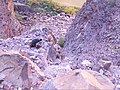 The rock slide located at the end of the Escalante Route
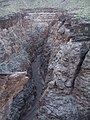 The slot canyon (75-mile Canyon) located along the Escalante Route
