Access to this part of the park by car is seasonal, open from mid-May to mid-October or depending on snow cover from the previous winter.
It is possible to reach the North Kaibab Trailhead by crossing the canyon on foot from the South Rim or by snowshoe or cross-country ski beginning at Jacob Lake, Arizona.
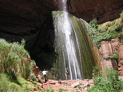
The trail is 14 miles (23km) long, with camping available by permit at Cottonwood Camp at 7 miles (11km) and Bright Angel Camp at 14 miles (23km). Treated water is available seasonally at the Supai Tunnel, Roaring Springs, the Caretaker's Dwelling, and Cottonwood Campground; and year-round at Bright Angel Campground and Phantom Ranch. Features along the trail include Roaring Springs, Ribbon Falls (140ft), The Box (a slot canyon), and Phantom Ranch.
Part of Arizona Trail
The North Kaibab Trail is also part of the Arizona Trail system, crossing the state of Arizona from Mexico to Utah. The trail is joined by South Kaibab Trail which is located to the south of the trail.
Hikers may only camp at the Bright Angel or Cottonwood Campgrounds, where they can stay overnight with a permit issued by the Grand Canyon National Park Backcountry Information Center. Use of the campground overnight is regulated by the National Park Service, and they call for a maximum number of groups (7 to 11 people) and parties (1 to 6 people), as well as a maximum total number of persons.[3]
Overnight camping areas near River Trail
Area
Name
Type
Group(s)
Parties
Max people
CCG
Cottonwood
Campground (summer) Campground (winter)
1 1
and or
6 1
40 8
CBG
Bright Angel
Campground
2
and
31
90
Use permits are available on a first-come, first-served basis from the park's Backcountry Information Center. Requests are taken beginning on the first day of the month, up to four months before the requested first night of camping.[4]
Hazards
Hazards hikers can encounter along the North Kaibab Trail include dehydration, sudden rainstorms, flash flooding, loose footing, rockfall, encounters with wildlife, and extreme heat. At the Colorado River, additional hazards include hypothermia (due to the river's consistently cold temperatures), trauma (due to collisions with boulders in rapids), and drowning.[5]
This page is based on this Wikipedia article Text is available under the CC BY-SA 4.0 license; additional terms may apply. Images, videos and audio are available under their respective licenses.