Backcountry Regulations
| | This section is empty. You can help by adding to it. (July 2010) |
The Grand Canyon National Park is a U.S. National Park located in the state of Arizona. The Park encompasses the Grand Canyon and the surrounding rim areas. The Park maintains an intricate trail system both above and below the rims of the canyon. To properly maintain and supervise the many trails and campgrounds in the backcountry of the Grand Canyon, Park implemented a system of zoning the different areas of the canyon and the surrounding rim area into backcountry "use areas," designated by a two-letter, one-number code system.
This code is used when applying for the required permits for any backcountry overnight camping and backpacking. Permits must be purchased from the Park for any overnight camping done in the within its borders. When applying for a permit, the permit-holder declares his/her intended camping schedule, by using the code for each area he/she intends on camping in, and stating how many days he/she will remain in the area.
The Park also created rules and regulations to help protect and preserve the Grand Canyon. These rules and regulations, such as Leave No Trace, range from limits on the amount of campers in one area, to rules that the campers must follow for safety and protection of the wildlife and wilderness. This system helps to assure the Grand Canyon remains one of the world's great wonders.
| | This section is empty. You can help by adding to it. (July 2010) |
| | This section is empty. You can help by adding to it. (July 2010) |
| Area | Name | Zone | Group(s) | Parties | Max People | Camp Type | |
|---|---|---|---|---|---|---|---|
| AA9 | Badger | Primitive | 1 | and | 1 | 17 | A/L |
| AU9 | Blacktail Canyon | Wild | 1 | or | 2 | 12 | A/L |
| BN9 | Boucher | Primitive | 1 | and | 2 | 23 | A/L |
| LB9 | Boysag | Wild | 1 | or | 2 | 12 | A/L |
| LK9 | Burnt Point | Wild | 1 | or | 2 | 12 | A/L |
| SA9 | Cape Final | Threshold | 0 | or | 1 | 6 | D/S |
| SA9 | Cape Solitude | Primitive | 1 | and | 2 | 23 | A/L |
| BC9 | Cardenas | Primitive | 1 | and | 2 | 23 | A/L |
| SB9 | Cedar Mountain | Threshold | 2 | or | 2 | 34 | A/L |
| AJ9 | Cheyava | Wild | 1 | or | 2 | 12 | A/L |
| AF9 | Chuar | Primitive | 1 | and | 3 | 29 | A/L |
| AK9 | Clear Creek | Threshold | 1 | and | 3 | 29 | A/L |
| CBG | Corridor-Bright Angel | Corridor | 2 | and | 31 | 90 | D/G |
| CCG | Corridor-Cottonwood (Summer) | Corridor | 1 | and | 6 | 40 | D/G |
| CCG | Corridor-Cottonwood (Winter) | Corridor | 1 | or | 1 | 8 | D/G |
| CIG | Corridor-Indian Garden | Corridor | 1 | and | 15 | 50 | D/G |
| BG9 | Cottonwood Creek | Primitive | 1 | and | 2 | 23 | A/L |
| BJ9 | Cremation | Primitive | 1 | and | 2 | 23 | A/L |
| AX9 | Deer Creek | Primitive | 1 | and | 1 | 17 | D/S |
| LG9 | Diamond Creek | Wild | 1 | or | 2 | 12 | A/L |
| SF9* | Eminence Break | Primitive | 1 | and | 1 | 17 | A/L |
| AY9 | Esplanade | Primitive | 1 | and | 2 | 23 | A/L |
| AZ9 | Fishtail | Wild | 1 | or | 2 | 12 | A/L |
| BS9 | Fossil | Wild | 1 | or | 1 | 1 | A/L |
| BR9 | Garnet | Primitive | 1 | and | 2 | 23 | A/L |
| LM9 | Grand Wash Cliffs | Primitive | 1 | and | 2 | 12 | A/L |
| BH9 | Grapevine | Primitive | 1 | and | 2 | 23 | A/L |
| AL9 | Greenland Springs | Wild | 1 | or | 2 | 12 | A/L |
| BE9 | Hance Creek | Primitive | 1 | and | 2 | 23 | A/L |
| BM7 | Hermit Loop-Hermit Creek | Threshold | 1 | and | 3 | 29 | D/S |
| BM8 | Hermit Loop-Hermit Rapids | Threshold | 1 | and | 1 | 17 | D/S |
| BL4 | Hermit Loop-Horn Creek | Threshold | 0 | and | 1 | 6 | D/S |
| BL5 | Hermit Loop-Salt Creek | Threshold | 0 | and | 1 | 6 | D/S |
| BL6 | Hermit Loop-Cedar Creek | Threshold | 0 | and | 1 | 6 | D/S |
| BL7 | Hermit Loop-Monument | Threshold | 1 | and | 3 | 29 | D/S |
| BL8 | Hermit Loop-Granite Rapids | Threshold | 1 | and | 2 | 23 | D/S |
| BL9 | Horseshoe Mesa | Threshold | 2 | and | 3 | 40 | D/S |
| SI9* | Jackass | Primitive | 1 | and | 1 | 17 | A/L |
| LA9 | Kanab Creek | Primitive | 1 | and | 2 | 23 | A/L |
| NK9 | Kanab Point | Primitive | 1 | and | 3 | 29 | A/L |
| NC9 | Ken Patrick | Primitive | 1 | and | 2 | 12 | A/L |
| NN9 | Lava | Threshold | 1 | and | 1 | 17 | A/L |
| AE9 | Nankwoeap | Primitive | 1 | and | 2 | 23 | A/L |
| BU9 | National | Wild | 1 | or | 2 | 12 | A/L |
| AS9 | North Bass | Primitive | 1 | and | 1 | 17 | A/L |
| BT9 | Olo | Wild | 1 | or | 2 | 12 | A/L |
| NG9 | Outlet | Primitive | 1 | and | 2 | 23 | A/L |
| BA9* | Palisades | Primitive | 1 | and | 2 | 23 | A/L |
| LE9 | Parashant | Wild | 1 | or | 2 | 12 | A/L |
| SE9 | Pasture Wash | Threshold | 2 | and | 3 | 40 | A/L |
| AP9 | Phantom Creek | Wild | 1 | or | 2 | 12 | A/L |
| NH9 | Point Sublime | Threshold | 2 | and | 3 | 34 | D/S |
| AT9 | Powell Plateau | Primitive | 1 | and | 2 | 23 | A/L |
| BD9 | Red Canyon | Primitive | 1 | and | 2 | 23 | A/L |
| AB9 | Rider | Primitive | 1 | and | 1 | 17 | A/L |
| ND9 | Robbers Roost | Primitive | 1 | and | 3 | 29 | A/L |
| BP9 | Ruby | Primitive | 1 | and | 2 | 23 | A/L |
| AD9 | Saddle Canyon | Primitive | 1 | and | 1 | 17 | A/L |
| SH9* | Saltwater Wash | Primitive | 1 | and | 1 | 17 | A/L |
| AR9 | Scorpion Ridge | Wild | 1 | or | 2 | 12 | A/L |
| LH9 | Separation | Wild | 1 | or | 2 | 12 | A/L |
| SG9* | Shinumo Wash | Primitive | 1 | and | 1 | 17 | A/L |
| BO9 | Slate | Primitive | 1 | and | 2 | 23 | A/L |
| LL9 | Snap Point | Primitive | 1 | or | 2 | 12 | A/L |
| BQ9 | South Bass | Primitive | 1 | or | 2 | 12 | A/L |
| AC9 | South Canyon | Primitive | 1 | and | 1 | 17 | A/L |
| LJ9 | Surprise | Wild | 1 | or | 2 | 12 | A/L |
| AM9 | Surprise Valley | Primitive | 1 | and | 1 | 17 | A/L |
| NJ9 | Swamp Ridge | Primitive | 1 | and | 3 | 29 | A/L |
| BB9 | Tanner | Primitive | 1 | and | 3 | 29 | A/L |
| AW7 | Tapeats-Upper Tapeats | Threshold | 1 | and | 2 | 23 | D/S |
| AW8 | Tapeats-Lower Tapeats | Threshold | 1 | and | 1 | 17 | D/S |
| AV9 | Tapeats Amphitheatre | Wild | 1 | or | 2 | 12 | A/L |
| LC9 | The Dome | Primitive | 1 | or | 2 | 12 | A/L |
| NB9 | Thompson Canyon | Primitive | 1 | and | 3 | 29 | A/L |
| NM9 | Toroweap Valley | Threshold | 1 | and | 2 | 23 | A/L |
| LF9 | Trail Canyon | Wild | 1 | and | 2 | 12 | A/L |
| AQ9 | Trinity Creek | Wild | 1 | and | 2 | 12 | A/L |
| NL9 | Tuckup Point | Primitive | 1 | and | 3 | 29 | A/L |
| AG9 | Unkar | Wild | 1 | or | 2 | 12 | A/L |
| AH9 | Vishnu | Wild | 1 | or | 1 | 11 | A/L |
| NA0 | Walhalla Plateau | Primitive | 1 | and | 3 | 29 | A/L |
| LI9 | Whitmore | Threshold | 1 | and | 1 | 17 | A/L |
| NF9 | Widforss | Threshold | 1 | and | 2 | 23 | A/L |
*Special permits are required from the Navajo Tribal Parks Department for the Marble Canyon use areas:
SF9, SI9, SH9, SG9 and the portion of the use area BA9 north of the confluence of the Little Colorado River.

A campsite or camping pitch is a place used for overnight stay in an outdoor area. In British English, a campsite is an area, usually divided into a number of pitches, where people can camp overnight using tents, campervans or caravans; this British English use of the word is synonymous with the US English expression campground. In American English, the term campsite generally means an area where an individual, family, group, or military unit can pitch a tent or park a camper; a campground may contain many campsites.
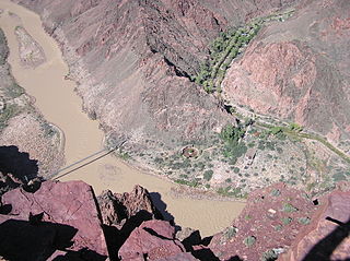
The South Kaibab Trail is a hiking trail in Grand Canyon National Park, located in the U.S. state of Arizona. Unlike the Bright Angel Trail which also begins at the south rim of the Grand Canyon and leads to the Colorado River, the South Kaibab Trail follows a ridge out to Skeleton Point allowing for 360-degree views of the canyon.

The Bright Angel Trail is a hiking trail located in Grand Canyon National Park in the U.S. state of Arizona.

Little River Canyon National Preserve is a United States National Preserve located on top of Lookout Mountain near Fort Payne, Alabama, and DeSoto State Park. Created by an Act of Congress in 1992, the 15,288-acre (6,187 ha) preserve protects what is sometimes said to be the nation's longest mountaintop river, the Little River. The canyon was historically called "May's Gulf", "gulf" being a common term throughout the Cumberland Plateau for this sort of feature. Prior to being assigned to the National Park Service, the canyon area formed the southmost unit of Alabama's DeSoto State Park.

Garibaldi Provincial Park, also called Garibaldi Park, is a wilderness park located on the coastal mainland of British Columbia, Canada, 70 kilometres (43.5 mi) north of Vancouver. It was established in 1920 and named a Class A Provincial Park of British Columbia in 1927. The park is a popular destination for outdoor recreation, with over 30,000 overnight campers and over 106,000 day users in the 2017/2018 season.

The Maroon Bells are two peaks in the Elk Mountains, Maroon Peak and North Maroon Peak, separated by about half a kilometer. The mountains are on the border between Pitkin County and Gunnison County, Colorado, United States, about 19 kilometres (12 mi) southwest of Aspen. Both peaks are fourteeners. Maroon Peak, at 4,317 metres (14,163 ft), is the 27th highest peak in Colorado. North Maroon Peak, at 4,273 metres (14,019 ft), is the 50th highest. The view of the Maroon Bells to the southwest from the Maroon Creek valley is very heavily photographed. The peaks are located in the Maroon Bells–Snowmass Wilderness of White River National Forest. Maroon Bells-Snowmass Wilderness was one of five areas in Colorado designated as wilderness in the original Wilderness Act of 1964. The Wilderness area surrounds the extremely popular Maroon Bells Scenic Area, which is a major access point for Wilderness travel.

Golden Ears Provincial Park is a Provincial park in British Columbia, Canada and is 555.9 square kilometres (214.6 sq mi). It is named after the prominent twin peaks which are commonly referred to as Golden Ears. The park's southern end is located on the northern edge of the district municipality of Maple Ridge on the north side of the Fraser River.

A wilderness hut, bothy, backcountry hut, or backcountry shelter is a free, primitive mountain hut for temporary accommodation, usually located in wilderness areas, national parks and along backpacking and hiking routes. They are found in many parts of the world, such as Finland, Sweden, Norway, northern Russia, the Alps, the Pyrenees, Scotland, Australia, New Zealand, Canada, and the United States. Huts are basic and unmanned, without running water.
The North Kaibab Trail is a hiking trail in the North Rim side of the Grand Canyon, in Grand Canyon National Park, located in the U.S. state of Arizona.

The Hermit Trail is a hiking trail in Grand Canyon National Park, located in the U.S. state of Arizona. This trail provides access to a historic area of Grand Canyon and offers a more challenging route to the Colorado River for more experienced canyon hikers.

The Cape Final Trail is a hiking trail on the North Rim of the Grand Canyon National Park, located in the U.S. state of Arizona.

The Tonto Trail is a hiking trail on the South Rim of the Grand Canyon in Grand Canyon National Park, located in the U.S. state of Arizona.

The River Trail is a hiking trail in Grand Canyon National Park, located in the U.S. state of Arizona. This trail connects the end of the Bright Angel Trail with Phantom Ranch and the South Kaibab Trail.

The Beamer Trail is a backpacking trail located on the South Rim of the Grand Canyon National Park, located in the U.S. state of Arizona.

The Tanner Trail is a hiking trail located on the South Rim of the Grand Canyon National Park, located in the U.S. state of Arizona. The trailhead is located at Lipan Point, a prominent lookout located to the east of the Grand Canyon Village, and the trail ends at the Colorado River at Tanner Rapids.

The North Bass Trail is a hiking trail located on the North Rim of the Grand Canyon, in Grand Canyon National Park, located in the U.S. state of Arizona.

John Harvey Butchart was a mathematics professor who was well known for his hiking exploits in and around the Grand Canyon in Arizona, United States. Beginning in 1945, Butchart explored the Grand Canyon's backcountry on foot. He wrote extensively about his adventures and influenced generations of canyoneers.
The New Hance Trail is a hiking trail on the South Rim of the Grand Canyon National Park, located in the U.S. state of Arizona. It is one of the "unmaintained" trails and, along with the similar Tanner Trail, is considered one of the most difficult trails on the South Rim. Unlike the Tanner Trail, there is no parking available at the trailhead, which is located about a 5-minute walk north of the South Rim main road. The trail ends at the Hance Rapids on the Colorado River. It is approximately 6.5 hiking miles and a 4400' descent from the South Rim main road at ~7040' to the Colorado River at ~2600' elevation.

The White Rim Road is a 71.2-mile-long (114.6 km) unpaved four-wheel drive road that traverses the top of the White Rim Sandstone formation below the Island in the Sky mesa of Canyonlands National Park in southern Utah in the United States. The road was constructed in the 1950s by the Atomic Energy Commission to provide access for individual prospectors intent on mining uranium deposits for use in nuclear weapons production during the Cold War. Large deposits had been found in similar areas within the region; however, the mines along the White Rim Road produced very little uranium and all the mines were abandoned.