Temple Butte

Last updated
Temple Butte
Colorado River GC.jpg
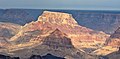
Temple Butte, and Lava Butte. Temple Butte is the mountain formation almost impossible to see that is located in the left background of this photo in front of a higher mountain formation with a black wall. Temple Butte's northeast slope is the crash site of Trans World Airlines Flight 2. Just behind Temple Butte is a higher mountain formation with a black wall, which is Chuar Butte. Chuar Butte's south wall is the crash site of United Airlines Flight 718.
Highest point
Elevation 5,308 ft (1,618 m) [1]
Prominence 859 ft (262 m) [1]
Parent peak Chuar Butte (6,500 ft) [1]
Isolation 1.77 mi (2.85 km) [1]
Coordinates 36°09′45″N111°49′26″W / 36.16250°N 111.82389°W / 36.16250; -111.82389 Coordinates: 36°09′45″N111°49′26″W / 36.16250°N 111.82389°W / 36.16250; -111.82389 [2]
Geography
USA Arizona relief location map.svg
Red triangle with thick white border.svg
Temple_Butte
Location in Arizona (confluence of the Little Colorado and Colorado rivers)
Location Palisades of the Desert, [3] East Rim, Grand Canyon
Settlement Grand Canyon Village, Arizona
Parent range East Rim, 2-mi [4] south of Little Colorado River with Colorado
Topo map USGS Cape Solitude
Geology
Mountain type sedimentary rock: sandstone, siltstone, mudstone, limestone, shale, sandstone
Type of rock Supai Group-(unit 4, eroded-prominence), Esplanade Sandstone),
Supai Group,
Redwall Limestone,
(Tonto Group-(3 units)),
3_Muav Limestone,
2_Bright Angel Shale,
1_Tapeats Sandstone
Climbing
Easiest route class 4 climbing [1]

Temple Butte, in the Grand Canyon, Arizona, US is a prominence below the East Rim. The butte lies on the west bank of the south-flowing Colorado River. The outfall from the Little Colorado River, draining from the Painted Desert to the east and southeast, is about two miles upstream.

Contents

Temple Butte is 5,308 feet (1,618 m) in elevation. It is the historical site of some wreckage of the 1956 Grand Canyon mid-air collision. It was first thought that smoke from Temple Butte, was due to a lightning strike fire, but later was found to be the result of the mid-air collision.

UAL & TWA crash sites. Chuar & Temple Buttes (TWA & UAL).jpg
UAL & TWA crash sites.

A closer view of Chuar and Temple Buttes.

Trails

The Tanner Trail from Desert View, Arizona down to the Colorado River, follows the west ridgeline of Tanner Canyon, and has numerous views looking due-north to Temple Butte. The trail ends at a viewpoint on the upper surfaces of a Redwall Limestone ridge. The Redwall Limestone is seen prominently below the East Rim, and is the cliff-forming shelf upon which the redbeds of the Supai Group accumulate.

Geology

The prominence of Temple Butte is composed of the upper unit of the Supai Group, ("redbeds"), the cliff-former, Esplanade Sandstone. The entire prominence is a much eroded, cliff remainder of the Esplanade, but the four units of the Supai Group, are compact, in an approximate north-south direction, with a large-pyramid-shape at the north, a pointed-pyramid at the south, and an eroded saddle in between.

The Supai Group sits on the platform, upper surface of the Redwall Limestone, on Cambrian rock units below. Another upper platform of the cliff-forming Muav Limestone, underlies the Redwall. (It is a double-platform rock unit.) The slopes of colorful Bright Angel Shale are below. And below that are the short cliffs of Tapeats Sandstone, (typically bordering gorges and the Colorado River), famous for making the Tonto Platform, above the 1,000-million year old Great Unconformity of lost time, and eroded rock units.

The east strike (section) of the Butte Fault is on the west side of Temple Butte. The west section of the Butte Fault is the East Kaibab Monocline. The Butte Fault sections are north-south trending, and are part of the uplift of the Kaibab Plateau.

Temple Butte, aerial from north Temple Butte, aerial from north.jpg
Temple Butte, aerial from north

Access

Desert View is the closest paved route site to Temple Butte viewpoints. It is located on the East Rim, and is about 20 mi (32 km) east of Grand Canyon Village, on the East Rim Road, (Arizona State Route 64). Desert View is also 32 mi (51 km) west of U.S. 89, by way of Arizona 64.

Observation viewpoints

Temple Butte can be viewed from the south at East Rim, Grand Canyon viewpoints in the vicinity of Desert View, Arizona. Lipan Point, Desert View Point, and to the south Hollenback Point have views due-north into the Grand Canyon. About 5 mi (8.0 km) north of Desert View Point by unimproved road, or hiking is Comanche Point, a distance of 5-mi south-southeast of Temple Butte.

An unimproved route, going north from Desert View, about 12 to 14 mi long ends at Cape Solitude; the point is adjacent the south canyon outfall of the Little Colorado River and canyon, with the Colorado River. Temple Butte is 2.5 mi (4.0 km) west. [5]

Related Research Articles

<span class="mw-page-title-main">Geology of the Grand Canyon area</span> Aspect of geology

The geology of the Grand Canyon area includes one of the most complete and studied sequences of rock on Earth. The nearly 40 major sedimentary rock layers exposed in the Grand Canyon and in the Grand Canyon National Park area range in age from about 200 million to nearly 2 billion years old. Most were deposited in warm, shallow seas and near ancient, long-gone sea shores in western North America. Both marine and terrestrial sediments are represented, including lithified sand dunes from an extinct desert. There are at least 14 known unconformities in the geologic record found in the Grand Canyon.

<span class="mw-page-title-main">Newton Butte</span> Prominence in the Grand Canyon, Arizona, United States

Newton Butte, in the Grand Canyon, Arizona, United States is a prominence below the South Rim, northwest of Grandview Point, and north on a ridgeline from Shoshone Point which is one mile east of Yaki Point, East Rim Drive. Shoshone Point and Yaki are both on access roads from East Rim Drive, with Yaki being the more advantageous to different viewing directions.

<span class="mw-page-title-main">Tonto Group</span> Cambrian geologic unit in the Grand Canyon region, Arizona

The Tonto Group is a name for an assemblage of related sedimentary strata, collectively known by geologists as a Group, that comprises the basal sequence Paleozoic strata exposed in the sides of the Grand Canyon. As currently defined, the Tonto groups consists of the Sixtymile Formation, Tapeats Sandstone, Bright Angel Shale, Muav Limestone, and Frenchman Mountain Dolostone. Historically, it included only the Tapeats Sandstone, Bright Angel Shale, and Muav Limestone. Because these units are defined by lithology and three of them interfinger and intergrade laterally, they lack the simple layer cake geology as they are typically portrayed as having and geological mapping of them is complicated.

<span class="mw-page-title-main">Muav Limestone</span> Geologic strata in Southwestern United States

The Cambrian Muav Limestone is a geologic unit within the 5-member Tonto Group. It is about 650 feet (198 m) thick at its maximum. It is a resistant cliff-forming unit. The Muav consists of dark to light-gray, brown, and orange red limestone with dolomite and calcareous mudstone. The Muav Limestone is overlain in the western Grand Canyon by the late Cambrian Frenchman Mountain Dolostone. Eastward, the Frenchman Mountain Dolostone pinches out and the Mississippian Redwall Limestone, which forms prominent vertical cliffs, directly lies upon the Muav Limestone. The Devonian Temple Butte Formation fill deep paleovalleys that have been cut through the Frenchman Mountain Dolostone and into the Muav Limestone.

<span class="mw-page-title-main">Toroweap Formation</span> Middle Permian geologic unit in the Grand Canyon

The Middle Permian Toroweap Formation is a thin, darker geologic unit, between the brighter colored units of the Kaibab Limestone above, and Coconino Sandstone below. It is a prominent unit in Grand Canyon, Arizona, USA, found through sections of the South Rim, Grand Canyon, and the North Rim, of the Kaibab Plateau; also the Kaibab's southeast extension to Cape Royal, the Walhalla Plateau. The Colorado River of the Grand Canyon makes its excursion from due-south to due-west around the Walhalla Plateau, as it enters the east end of the Grand Canyon's interior, Granite Gorge. The formation is also found in southeast Utah.

<span class="mw-page-title-main">Isis Temple</span> Landform in the Grand Canyon, Arizona

Isis Temple is a prominence in the Grand Canyon, Arizona, Southwestern United States. It is located below the North Rim and adjacent to the Granite Gorge along the Colorado River. The Trinity Creek and canyon flow due south at its west border; its north, and northeast border/flank is formed by Phantom Creek and canyon, a west tributary of Bright Angel Creek; the creeks intersect about 3 mi (4.8 km) southeast, and 1.0 mi (1.6 km) north of Granite Gorge. The Isis Temple prominence, is only about 202 ft (62 m) lower than Grand Canyon Village, the main public center on Grand Canyon’s South Rim.

<span class="mw-page-title-main">Grand Canyon Supergroup</span> Sequence of sedimentary strata

The Grand Canyon Supergroup is a Mesoproterozoic to a Neoproterozoic sequence of sedimentary strata, partially exposed in the eastern Grand Canyon of Arizona. This group comprises the Unkar Group, Nankoweap Formation, Chuar Group and the Sixtymile Formation, which overlie Vishnu Basement Rocks. Several notable landmarks of the Grand Canyon, such as the Isis Temple and Cheops Pyramid, and the Apollo Temple, are surface manifestations of the Grand Canyon Supergroup.

<span class="mw-page-title-main">Esplanade Sandstone</span> Geologic unit found in the Grand Canyon

The Lower Permian Esplanade Sandstone is a cliff-forming, resistant sandstone, dark red, geologic unit found in the Grand Canyon. The rock unit forms a resistant shelf in the west Grand Canyon, south side of the Colorado River, at the east of the Toroweap Fault, down-dropped to west, southeast of Toroweap Overlook, and west of Havasupai. The red, sandstone shelf, The Esplanade is about 20-mi long. At Toroweap Overlook region, Toroweap Valley with Vulcan's Throne, Uinkaret volcanic field, the resistant Esplanade Sandstone is described in access routes exploring the Toroweap Lake area.

<span class="mw-page-title-main">Chuar Butte</span> Landform in the Grand Canyon, Arizona

Chuar Butte is a prominent 6,500-foot-elevation (2,000-meter) summit located in the Grand Canyon, in Coconino County of northern Arizona, US. It is situated 1.5 miles northwest of Cape Solitude on the canyon's East Rim, three miles southeast of Gunther Castle, and immediately west of the confluence of the Colorado River and Little Colorado River. This position also places it where Marble Canyon ends, and the Grand Canyon begins. Topographic relief is significant as it rises nearly 3,800 feet above the river in less than one mile. According to the Köppen climate classification system, Chuar Butte is located in a cold semi-arid climate zone.

<span class="mw-page-title-main">The Howlands Butte</span> Summit in Coconino County, Arizona

The Howlands Butte, elevation 5,572 feet (1,698 m), is a minor butte in the southeast drainage of the very large Clear Creek drainage. Clear Creek is a medium length flowing creek, just upstream of the major Bright Angel Creek outfall into the Colorado River, Granite Gorge. The Howlands Butte was officially named in 1932 for brothers Seneca and Oramel G. Howland, members of the Powell Geographic Expedition of 1869. Just two days from the expedition's intended destination, the pair and William H. Dunn left the expedition, fearing they could not survive the dangers of the river much longer. They hiked out of the canyon and were never seen again. Separation Rapids on the river is where they departed from Powell.

<span class="mw-page-title-main">Horus Temple</span> Summit in the Grand Canyon, Arizona

Horus Temple is a 6,150 ft elevation summit located in the Grand Canyon, in Coconino County of Arizona, Southwestern United States. This butte is situated as the central landform in a 3-series line of peaks southwest of the Shiva Temple (forested)-tableland prominence.

<span class="mw-page-title-main">Malgosa Crest</span> Landform in the Grand Canyon, Arizona

Malgosa Crest is a 5,446-foot-elevation summit located in the eastern Grand Canyon, in Coconino County of northern Arizona, US. The ridgeline-crest is situated adjacent to the East Rim, being a middle, and minor prominence,, along the Butte Fault. From south to north, and bordering the due-south flowing Colorado River, are Chuar Butte, Awatubi Crest, Kwagunt Butte, Malgosa Crest, and the Nankoweap Mesa. All the prominences are near the end of Marble Canyon,, Marble Canyon being the start of the Grand Canyon.

<span class="mw-page-title-main">Dunn Butte</span> Landform in the Grand Canyon, Arizona

Dunn Butte, is a 5,714 foot-elevation-summit, a minor butte, along a line of three summits along the west drainage of Ninetyone Mile Canyon and Creek. From higher elevation-to-lower, they are Angels Gate, Dunn Butte, and Hawkins Butte. The bases of all three landforms are connected, and Dunn Butte is a south-southwest ridgeline, with the high point prominence at the northeast terminus.

<span class="mw-page-title-main">The Alligator (Grand Canyon)</span> Landform

The Alligator (Grand Canyon), is a 5,774-foot (1,760 m)-elevation summit, a large ridgeline butte, connected to, and below Mohave Point (South Rim), approximately 1.5 miles (2.4 km) northwest of Grand Canyon Village, Grand Canyon. The ridgeline trends north, and the lower elevation cliff, the tail of the alligator, turns northwest. The Alligator landform is about 1.0 mile (1.6 km) from the west-flowing Colorado River, and Granite Gorge. The Alligator lies between the Monument Creek (Grand Canyon) drainage, west, and the Salt Creek (Grand Canyon) drainage, east, both short, south tributaries to the Colorado.

<span class="mw-page-title-main">Rama Shrine</span> Landform in the Grand Canyon, Arizona

Rama Shrine is a 6,406-foot (1,953 m)-elevation platform-summit located in the eastern Grand Canyon, in Coconino County of northern Arizona, United States. The Shrine is named for Rama, the Hindu god of chivalry and virtue. The landform is attached at the southeast to the Vishnu Temple massif, about 1.0 mile (1.6 km) distant. Rama Shrine is about 3.0 miles (4.8 km) southeast of the Cape Royal overlook, Walhalla Plateau. A twin landform occupies the southwest of Vishnu Temple, the Krishna Shrine. Rama Shrine towers about 4,000 feet (1,200 m) above the Colorado River, about 2.0 miles (3.2 km) southeast. Drainages to the Colorado are east and southeast; between the two Shrines, is the south Asbestos Canyon drainage.

The Rama Shrine prominence is a rectangular platform of the Supai Group, the cliff-former, hard Esplanade Sandstone. Remainder debris of very-shallow slopes of burnt-red Hermit Shale cover the horizontal platform.

<span class="mw-page-title-main">Krishna Shrine</span> Landform in the Grand Canyon, Arizona

Krishna Shrine is a 6,131-foot-elevation summit located in the eastern Grand Canyon, in Coconino County of northern Arizona, US. The landform is attached at the southwest to the Vishnu Temple massif, about 1.0 mi distant. Krishna Shrine is about 3.0 mi south of the Cape Royal overlook, Walhalla Plateau. A twin landform occupies the southeast of Vishnu Temple, the Rama Shrine. Krishna Shrine towers about 4,000 ft above the Colorado River, about 2.0 miles south. Both Shrines, east and west, and Vishnu Temple, center, are at the headwater drainage of Asbestos Canyon. At the southwest of Krishna, on an extending arm of Redwall Limestone is a short unnamed drainage;. The west flank of Krishna Shrine drains into the long southwest-trending Vishnu Canyon and Creek, which comes from Freya Castle and the Walhalla Plateau, South Rim.

<span class="mw-page-title-main">The Battleship (Grand Canyon)</span> Landform in the Grand Canyon, Arizona

The Battleship is a 5,850-foot (1,780 m)-elevation summit located in central Grand Canyon, in Coconino County of northern Arizona, United States. The ridgeline, Battleship landform forms part of the western border of Garden Creek Canyon, which contains the Bright Angel Trail down to the Colorado River, and across it to Phantom Ranch. The east border of Garden Creek Canyon is the South Rim, with the overlooks of Grandeur Point and Yavapai Point. The Battleship is 1.5 miles (2.4 km) northwest of Yavapai Point, 1.5 miles due-north of Grand Canyon Village, and roughly 2.0 miles (3.2 km) southwest of the Colorado River.

<span class="mw-page-title-main">Topaz Canyon</span> Landform in the Grand Canyon, Arizona

Topaz Canyon is a linear, narrow canyon in the western Grand Canyon, below the South Rim. It lies in a region of four canyons, and a fifth smaller canyon, all trending mostly northeasterly towards the west-flowing Colorado River, in western Grand Canyon National Park. The name of Topaz Canyon was named by the Board of Geographical Names for precious stones of the region. Topaz Canyon is the southeast border of the linear, and major, forested-landform, Diana Temple; .

The northeast terminus of Topaz Canyon intersects with the outfall of Boucher Canyon and the tract of the Tonto Trail. The Boucher Trail starting in Hermit Canyon,, ends at the termini of both Topaz and Boucher Canyons.

<span class="mw-page-title-main">Cocopa Point</span> Landform in the Grand Canyon, Arizona

Cocopa Point is a 6,627 foot (2,020 m)-cliff-elevation Point located in the central,, Grand Canyon, Coconino County of northern Arizona, United States. Cocopa Point is 1.1 miles from its closest highest scenic viewpoint, Yuma Point (6,654 ft), located east at Eremita Mesa, at the northeast, overlooking Central Hermit Canyon.

Cocopa Point is in a region of points, at the headwaters of canyons, and landforms below the South Rim. Mimbreno Point lies ~1.7 miles west, and Hermit Canyon and Pima Point, at the west-terminus of West Rim Drive, are about 1.5 mi and 2.0 miles due-east. Cocopa Point is at the northwest of Eremita Mesa; Yuma Point is at the northeast; the mesa lies between Hermit Canyon, east, and Upper Boucher Canyon, west. Cocopa Point is a sheer-walled cliff, sitting at the northwest headwaters of short, Travertine Canyon. At the west of Lower Travertine Canyon, adjacent the Colorado River, sits Whites Butte, about 1.2 miles distant from Cocopa Point.

<span class="mw-page-title-main">Tuna Canyon</span> Landform in the Grand Canyon, Arizona

Tuna Canyon is a short, high-angle, descending, narrow canyon in western Grand Canyon, below the North Rim. It lies across Granite Gorge in a region of four canyons, and a fifth smaller canyon, as the Colorado River courses westward around the Point Sublime, , ridgelines. The high-angle of Tuna Canyon, Tuna Creek, creates the Tuna Creek Rapids (Rapid) at the outfall. Tuna Canyon is a short canyon, nestled between the ridges, but just east is the very long drainage of Crystal Creek (Arizona), which drains from the Kaibab Plateau. The Crystal Rapid is adjacent upstream from the Tuna Creek Rapids.

References

  1. 1 2 3 4 5 "Temple Butte – 5,308' AZ". Lists of John. Retrieved January 2, 2021.
  2. "Temple Butte". Geographic Names Information System . United States Geological Survey, United States Department of the Interior . Retrieved 2021-01-02.
  3. Arizona Road & Recreation Atlas, Benchmark Maps, p. 29.
  4. Arizona Road & Recreation Atlas, p. 29.
  5. Arizona DeLorme Atlas & Gazetteer, p. 32.