The Chuckwalla Mountains are a mountain range in the transition zone between the Colorado Desert—Sonoran Desert and the Mojave Desert, climatically and vegetationally, in Riverside County of southern California.

The La Posa Plain is a wide, generally flat plain in western Arizona near the Colorado River and is on the west and northwest border of the Kofa National Wildlife Refuge. The plain lies to the east of the Colorado River Indian Reservation and east of the Dome Rock and Trigo Mountains. Quartzsite, Arizona, lies on the western part of the plain, which crosses both Interstate 10 and U.S. Route 95.
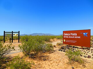
Cabeza Prieta National Wildlife Refuge (CPNWR) is located in southwestern Arizona in the United States, along 56 miles (90 km) of the Mexico–United States border. It is bordered to the north and to the west by the Barry M. Goldwater Air Force Range, to the south by Mexico's El Pinacate y Gran Desierto de Altar Biosphere Reserve, to the northeast by the town of Ajo, and to the southeast by Organ Pipe Cactus National Monument.

The Kofa National Wildlife Refuge is located in Arizona in the southwestern United States, northeast of Yuma and southeast of Quartzsite. The refuge, established in 1939 to protect desert bighorn sheep, encompasses over 665,400 acres (2,693 km2) of the Yuma Desert region of the Sonoran Desert. Broad, gently sloping foothills as well as the sharp, needlepoint peaks of the Kofa Mountains are found in the rugged refuge. The small, widely scattered waterholes attract a surprising number of water birds for a desert area. A wide variety of plant life is also found throughout the refuge. Kofa Wilderness takes up 547,719 acres of the refuge, making it the second largest wilderness area in Arizona.
Today's Bradshaw Trail is a historic overland stage route in the western Colorado Desert of Southern California. It is a remnant of the much longer Bradshaw Road, also known as the Road to La Paz, or Gold Road, established in 1862 by William D. Bradshaw. It was the first overland route to connect the gold fields near La Paz in the U.S. New Mexico Territory, later the Arizona Territory, to Southern California's more populated west coast. Once in La Paz, additional roads provided access to the mining districts of the central New Mexico/Arizona Territory, near Wickenburg and Prescott.

Trigo Mountains Wilderness is a 30,300-acre (12,262 ha) wilderness area in the U.S. state of Arizona and was established in 1990. It is located 30 miles (48 km) north of Yuma east of the Colorado River in an area called the Lower Colorado River Valley. It is a 15-mile (24 km) stretch of ridgeline of the rugged desert Trigo Mountains and is adjacent to historical mines, the Red Cloud and Hart Mine. These rugged desert mountain ecosystems are home to the Desert Bighorn Sheep.
The Trigo Mountains are a north-south trending mountain range in La Paz County, Arizona, bordering the Colorado River on the east in the Lower Colorado River Valley. The range lies north of the Colorado River as it turns east, north of Martinez Lake and the Imperial Reservoir. The Trigo Mountains are on a north-south stretch of the Colorado River, and form the eastern perimeter of the Imperial National Wildlife Refuge.

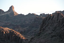
The Kofa Mountains of Yuma and La Paz counties in Arizona is the central mountain range of the Kofa National Wildlife Refuge. The range lies about 60 miles northeast of Yuma in the southwestern part of the state. Kofa Wilderness takes up 547,719 acres of the refuge, making it the second largest wilderness area in Arizona. The equally extensive Castle Dome Mountains comprise the southern refuge border; the western end of the Tank Mountains are in the southeast of the wildlife refuge, and the New Water Wilderness in the New Water Mountains ends the extension of the Kofa National Wildlife Refuge to the north. Scenic "King Valley" is south of the Kofa Mountains between the Castle Dome Mountains.
The Tank Mountains are a mountain range in the Sonoran Desert of southwest Arizona; the range is part of the southeastern border of the Kofa National Wildlife Refuge.

The Bill Williams River is a 46.3-mile-long (74.5 km) river in west-central Arizona where it, along with one of its tributaries, the Santa Maria River, form the boundary between Mohave County to the north and La Paz County to the south. It is a major drainage westwards into the Colorado River of the Lower Colorado River Valley south of Hoover Dam and Lake Mead, and the drainage basin covers portions of northwest, and west-central Arizona. The equivalent drainage system paralleling the east–west lower reaches of the Bill Williams is the Gila River, which flows east-to-west across central Arizona, joining the Colorado River in the southwest at Yuma. The confluence of the Bill Williams River with the Colorado is north of Parker, and south of Lake Havasu City.
The Dome Rock Mountains are a mountain range in southern La Paz County, Arizona. The range borders the Colorado River on the west and the Colorado River Indian Reservation on the northwest located in the Lower Colorado River Valley. Quartzsite, Arizona lies on the eastern foothills of the range.
Tyson Wash is one of the larger eastern-bank dry washes that enter the Colorado River in western Arizona. It drains the La Posa Plain south-to-north and is also coincident with the Plain's southern two thirds.
The Agua Dulce Mountains are a mountain range in the north-central Sonoran Desert of southwestern Arizona. The range is located in the extreme southwestern portion of Pima County, Arizona, immediately north of the international boundary with Mexico and about 30 mi (48 km) southwest of Ajo, Arizona. The range has three main sections that total about 15 miles in length and about nine miles in width. The range is located entirely within the Cabeza Prieta National Wildlife Refuge. The highpoint of the range is 2,852 feet (869 m) above sea level and is located at 32°01'32"N, 113°08'44"W. The summit is unnamed, but is marked on U.S. Geological Survey (USGS) maps for the "Quitovaquita" benchmark that was placed on the summit in 1920. The original surveyed height was 2,850 feet above sea level, but recent datum adjustments calculate the summit to be two feet higher.

The Altar Valley is a 45-mile (72 km) long north–south valley, trending slightly northeast from Sasabe, Arizona on the Mexico border to the Avra Valley west of the Tucson Mountains. It is delimited by Arizona State Route 86, from east-to-west on the north separating it from the Avra Valley which then trends northwesterly, merging into the plains and drainage of the Santa Cruz River.
The Harcuvar Mountains are a narrow mountain range in western-central Arizona, United States. The range lies just east of the north–south Colorado River, and south of the east–west, west-flowing Bill Williams River, from Alamo Lake.

The Buckskin Mountains is a mountain range in La Paz County, Arizona, United States. The range lies just east of the north–south Colorado River, and borders south of the east–west, west-flowing Bill Williams River.
The Little Harquahala Mountains are a small, arid, low-elevation mountain range of western-central Arizona, in southeastern La Paz County.

The Black Hills of Yavapai County are a large mountain range of central Arizona in southeast Yavapai County. It is bordered by the Verde Valley to the east. The northwest section of the range is bisected from the southeast section by Interstate 17, which is the main route connecting Phoenix to Sedona, Oak Creek Canyon, and Flagstaff. This bisection point is the approximate center of the mostly northwest by southeast trending range. The northwest section contains a steep escarpment on the northeast with the Verde Valley, the escarpment being the location of the fault-block that created the historic mining district at Jerome. The United Verde Mine was one of the largest copper mines in the United States, producing large quantities of copper, gold, silver and zinc.

The Poachie Range is a moderate length mountain range and massif in southeast Mohave County, Arizona, and the extreme southwest corner of Yavapai County; the range also abuts the northeast corner of La Paz County. The Poachie Range massif is bordered by the south-flowing Big Sandy River on its west, and the west-flowing Santa Maria River on its south; both rivers converge at the Poachie Range's southwest at Alamo Lake in Alamo Lake State Park.