
Humphreys Peak is the highest natural point in the U.S. state of Arizona, with an elevation of 12,637 feet (3,852 m) and is located within the Kachina Peaks Wilderness in the Coconino National Forest, about 11 miles (17.7 km) north of Flagstaff, Arizona. Humphreys Peak is the highest of a group of dormant volcanic peaks known as the San Francisco Peaks.

The South Mountains, known locally as simply South Mountain, is a mountain range in central Arizona in south Phoenix, Arizona. It is on public land managed by the city of Phoenix as South Mountain Park.

Camelback Mountain is a mountain in Phoenix, Arizona, United States. The English name is derived from its shape, which resembles the hump and head of a kneeling camel. The mountain, a prominent landmark of the Phoenix metropolitan area, is located in the Camelback Mountain Echo Canyon Recreation Area between the Arcadia neighborhood of Phoenix and the town of Paradise Valley. It is a popular recreation destination for hiking and rock climbing.
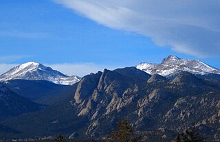
The Mummy Range is a mountain range in the Rocky Mountains of northern Colorado in the United States. The range is a short subrange of the Front Range located in southwestern Larimer County northwest of the town of Estes Park. It is located largely within Rocky Mountain National Park, extending north from Trail Ridge Road approximately 15 miles (24 km).

Kendrick Peak or Kendrick Mountain is one of the highest peaks in the San Francisco volcanic field north of the city of Flagstaff in the U.S. State of Arizona and is located on the Coconino Plateau in Coconino County.

Miller Peak, at 9,470 feet (2,886 m), is the second-highest mountain in Cochise County, Arizona. Located approximately 10 miles south of Sierra Vista, Arizona, it is the highest mountain in the Huachuca mountain range and a popular local hiking destination. The peak is the highest point in the Miller Peak Wilderness on the Coronado National Forest. This is also the most southerly peak and land area to rise above 9,000 feet in the continental United States. The area was affected by the 2011 Monument fire and most of the pine trees seen in older photographs were burned and destroyed. Scrub oak are beginning to replace the areas that were previously covered by pine.

Agassiz Peak is the second-highest mountain in the U.S. state of Arizona at 12,360 feet (3,767 m). It is located north of Flagstaff, Arizona in the San Francisco Peaks. It is in the Kachina Peaks Wilderness on the Coconino National Forest. The peak was named for Louis Agassiz, the celebrated naturalist.

Roof Butte is a peak in the Chuska Mountains in Arizona, United States. Roof Butte is the highest peak of the Chuska Mountains which run in a north-northwest direction across the Arizona-New Mexico border. Roof Butte is a visible butte for miles around. The butte has an elevation of 9,787 feet (2,983 m). A manned-lookout tower is located on Roof Butte. Two funnel shaped explosion volcanic pipes formed the flattish summit of Roof Butte, and a low lava dome caps one nearby peak.

Mount Baldy is a mountain in eastern Arizona in the United States. It is the highest point in the White Mountains and Apache County. It is the fifth-highest point in the state, and the highest outside the San Francisco Peaks in the Flagstaff area. With a summit elevation of 11,409 feet (3,477 m), the peak of Mount Baldy rises above the tree line and is left largely bare of vegetation, lending the mountain its current name.

The Mazatzal Mountains are a mountain range in south central Arizona, about 30–45 miles northeast of Phoenix and the Phoenix metropolitan area. The origin of the name remains obscure but one possibility is that it is from the Aztec language meaning "place of the deer". The crest of the Mazatzals forms the county line between Maricopa County and Gila County. SR 87, the Beeline Highway, traverses the Mazatzals on its way to Payson. The highest peak is Mazatzal Peak at 7,903 feet (2,409 m). They also include the Four Peaks, with elevation 7,659 ft, 2,334 m; a prominent mountain and landmark of the eastern Phoenix area.

The Whetstone Mountains is a mountain range in Cochise County, southeastern Arizona.
Sepulcher Mountain el. 9,642 feet (2,939 m) is a moderate mountain peak in northwest Yellowstone National Park halfway between the summit of Electric Peak and Mammoth Hot Springs. The peak was named Sepulcher by Captain John W. Barlow, U.S. Army in 1871 because of its resemblance to a crypt when viewed from Gardiner, Montana.
The Centennial Wash is a northern minor wash tributary to the west-flowing Bill Williams River. The wash drains from the western third of the Rawhide Mountains, and partially forms the southeast border of the wilderness at the northwest of the Rawhide's, the Aubrey Peak Wilderness.
The Rawhide Mountains are a mountain range of western Arizona, in the southwest of Mohave County. It is part of a block of mountain ranges on the north of an insular region called the Maria fold and thrust belt, containing mountain ranges, valleys, and plains. The Rawhide Mountains border the much smaller Artillery Mountains southeast, bordering on Alamo Lake State Park and the south-flowing Big Sandy River.
Dutch Flat of Arizona is a valley south of the Sacramento Valley and Interstate 40 in southern Mohave County.
The Aquarius Mountains are a 45-mi (72 km) long mountain range in southeast Mohave County, Arizona. The range lies in the northwest of the Arizona transition zone, and at the southwest of the Coconino Plateau, a subsection of the Colorado Plateau.

Thompson Peak is located in the McDowell Mountains, the summit being 20 miles (32 km) to the northeast of Phoenix, Arizona. Its height is 3,984 feet (1,214 m). Thompson Peak has amateur and Maricopa County government radio towers on the summit, accessible via a service road from Fountain Hills.

Aubrey Valley is a 35-mile (56 km) long valley located in southwest Coconino County, Arizona with the northwest border of Yavapai County. The valley is located at the southwest border of the Aubrey Cliffs; to the west and southwest, the Yampai Divide and the Seventyfour Plains form flatlands between four bordering mountain ranges at the northwest terminus of the Arizona transition zone.

The Toroweap Fault of northwest Arizona and southwest Utah is part of a fault system of the west Grand Canyon region, Arizona, USA; also the west perimeter regions of the Coconino and Colorado Plateaus. The Hurricane Fault originates at the Toroweap Fault, in the region of the Colorado River, and strikes as the westerly expression of the Toroweap Fault. The Toroweap strikes northerly from the Colorado at the east of Toroweap Valley, and enters south Utah; from the Colorado River, the Hurricane Fault strikes north-northwest along the west flank of the small, regional Uinkaret Mountains, the west border of Toroweap Valley. The Hurricane Fault, and the Hurricane Cliffs strike into southwest Utah as part of the west, and southwest perimeter of the Colorado Plateau. The Hurricane Cliffs are made of Kaibab Limestone, an erosion resistant, cliff-forming rock unit.

Gavilan Peak is northwest of Daisy Mountain, north of Anthem, Arizona and southeast of New River, Arizona. Considering its steepness, it is climbed much less frequently than Daisy Mountain. It was named in the 1880s, when the U.S. Cavalry and the Apaches fought a battle in the area. The name means 'sparrow hawk' in Spanish and 'hawk' in Apache.


