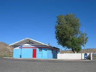
Teec Nos Pos is a census-designated place (CDP) in Apache County, Arizona, United States. The population was 730 at the 2010 census. The Navajo name of this community translates as "cottonwoods in a circle." It is the western terminus of U.S. Route 64.

The Cutler Formation or Cutler Group is a rock unit that is spread across the U.S. states of Arizona, northwest New Mexico, southeast Utah and southwest Colorado. It was laid down in the Early Permian during the Wolfcampian stage. Its subunits, therefore, are variously called formations or members depending on the publication. Members :

Rio Rico is an unincorporated community and census-designated place (CDP) in Santa Cruz County, Arizona, United States. The population was 18,962 at the 2010 census. The Rio Rico CDP replaced the former CDP's of Rio Rico Northwest, Rio Rico Northeast, Rio Rico Southwest, and Rio Rico Southeast.

The Palo Verde Dam is a diversion dam on the Colorado River in La Paz County, Arizona, and Riverside County, California, in the southwestern United States, approximately 9 miles (14 km) northeast of Blythe. The dam is earthen and rockfill, built solely to divert water into irrigation canals serving the Palo Verde Irrigation District. It measures 1,850 feet (560 m) long at its crest, which is at an elevation of 283.5 feet (86.4 m), and stands 46 feet (14 m) high above the riverbed, containing approximately 175,000 cubic yards (134,000 m3) of material. Construction of the dam, which began in 1956 and ended in 1958, was authorized by the U.S. Bureau of Reclamation. The dam was constructed to raise the water level of the river because the upstream Hoover and Davis Dams blocked sediment, causing significant degradation of the riverbed that hampered water diversion.

The Sunset Mountains in Coconino County, Arizona are two a small mesas known as East Sunset Mountain and West Sunset Mountain, located southeast of Winslow. State Route 87 passes between the mountains.

Red Rock is an unincorporated community and census-designated place (CDP) in Apache County, Arizona, United States. Red Rock is located on the Navajo Nation near the New Mexico border, 16 miles (26 km) northeast of Lukachukai. Red Rock has a post office with ZIP code 86544; the post office uses the Red Valley name. As of the 2010 census, the Red Rock CDP had a population of 169.

Mexican Water is an unincorporated community in Apache County, Arizona, United States. Mexican Water is located on the Navajo Nation 14 miles (23 km) west of Red Mesa. It is also approximately four miles east of Tes Nez Iah.

Juniper Mesa Wilderness is a 7,406-acre wilderness area in the Prescott National Forest in the U.S. state of Arizona. The mesa is about an hour's drive northwest of Prescott in the Juniper Mountains of Yavapai County. The wilderness varies in elevation from 5,600 to 7,000 feet. It is entirely within the Juniper Mountain quadrangle of the United States Geological Survey (USGS) topographic map.

Prewitt is an unincorporated community and census-designated place in McKinley County, New Mexico, United States. Prewitt is located along Interstate 40, 18 miles (29 km) northwest of Grants. Prewitt has a post office with ZIP code 87045.

Mescal is a Census-designated place located in Cochise County, Arizona, United States.

Apache Wells is a populated place and retirement community situated within the boundaries of Mesa in Maricopa County, Arizona, United States. Apache Wells was established in 1962 and developed by the Hughes family. It has an estimated elevation of 1,427 feet (435 m) above sea level.

Fortification Hill is a prominence adjacent to Lake Mead in the Lake Mead National Recreation Area; it is located at the northwest terminus region of the Black Mountains (Arizona), and specifically the north region of the Black Mountains. It is near a southern section of Lake Mead, and just northeast of Hoover Dam. It can easily be seen eastward across Las Vegas Bay or from the two northern mountain terminuses of Eldorado Mountains (Nevada), or the Black Mountains (Arizona).

Castle Canyon Mesa is a populated place situated in Yavapai County, Arizona, United States. It has an estimated elevation of 5,180 feet (1,580 m) above sea level.

Dreamland Villa is a retirement community situated in Maricopa County, Arizona, United States. It was one of the first retirement communities built in Arizona. Begun as a development in 1959 by Ross Farnsworth, within fifteen years it encompassed 3000 homes. It has an estimated elevation of 1,371 feet (418 m) above sea level.

Rancho Mesa Verde is a census-designated place in Yuma County, in the U.S. state of Arizona. The population was 625 at the 2010 census.

Diana Temple is a 6,683-foot-elevation (2,037 meter) summit located in the Grand Canyon, in Coconino County of northern Arizona, USA. It is situated nine miles northwest of Grand Canyon Village, and immediately northeast of Mescalero Point. Pollux Temple is one mile northwest, Marsh Butte one mile east-northeast, and Vesta Temple is one mile south. Topographic relief is significant as Diana Temple rises nearly 4,300 feet (1,310 meters) above the Colorado River in less than two miles. Diana Temple is named for Diana, the goddess of the hunt and the moon according to Roman mythology. Clarence Dutton began the practice of naming geographical features in the Grand Canyon after mythological deities. The U.S. Geological Survey applied the name, and this geographical feature's name was officially adopted in 1908 by the U.S. Board on Geographic Names. In the early 1900s this mesa was sometimes called "No Mans Land". According to the Köppen climate classification system, Diana Temple is located in a Cold semi-arid climate zone.


