Agua Caliente, Aguas Calientes or Aguascalientes may refer to:
Tanque Verde Falls are a series of waterfalls in Tanque Verde Canyon east of Tanque Verde, Arizona and Tucson, Arizona. Tanque Verde Ridge of the Rincon Mountains lies to the south and Agua Caleinte Hill to the north. The falls lie south of Redington Road which connects the Tucson Valley to the southwest with the San Pedro River valley to the east.

Hyder is a populated place and farming community in Yuma County, Arizona, United States. Hyder and surrounding areas house several different types of fish, shrimp, and other types of farms, one school, and two gas stations/general markets. There was also a bar at one point, which was really nothing more than a tin-topped shed, but it was closed some time in 1997 due to a change of ownership and lack of business. The Gila River runs through Hyder, although it is dry most of the time. Hyder is also known for its extremely hot temperatures in the summer.
The Copper Mountains is a minor north–south trending mountain range, only 8 miles long in southwestern Arizona in the southwestern Sonoran Desert.

The Muggins Mountains is a mountain range in southwest Arizona east of Yuma, Arizona, northeast of the Gila Mountains, and east of the Laguna Mountains. The Castle Dome Mountains lie to the northeast across the broad Castle Dome Plain. The Muggins Mountains Wilderness occupies the southwest portion of the range.

The Tank Mountains are a mountain range in the Sonoran Desert of southwest Arizona; the range is part of the southeastern border of the Kofa National Wildlife Refuge.

Mohawk is a populated place in Yuma County, Arizona, United States. It is part of the Yuma Metropolitan Statistical Area.

The Mohawk Mountains is a mountain range in the northwest Sonoran Desert of southwest Arizona. It abuts the western Gila River valley to the north, and is located in southern Yuma County. The Mohawk Valley lies adjacent and southwest of the range; the San Cristobal Valley is northeast.

The Gila River Valley is a multi-sectioned valley of the Gila River, located primarily in Arizona. The Gila River forms in western New Mexico and flows west across southeastern, south-central, and southwestern Arizona; it changes directions as it progresses across the state, and defines specific areas and valleys. The central portion of the river flows through the southern Phoenix valley region, and the final sections in southwestern Arizona form smaller, irrigated valleys, such as Dome Valley, Mohawk Valley, and Hyder Valley.
Warner Springs is set of springs and a small unincorporated community in northern San Diego County, California.

The Sawtooth Mountains are a mountain range of the Peninsular Ranges system, located in eastern San Diego County, California.
The West Silver Bell Mountains are a small 10 mile (16 km) long mountain range of south-central Arizona, United States. The range lies in the north-central arid Sonoran Desert; the Madrean Sky Islands region of southeast Arizona, around Tucson is adjacent to the southeast.

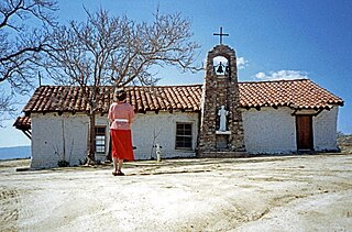
Agua Caliente in Maricopa County, Arizona on the border with Yuma County, is a place north of the Gila River near Hyder, Arizona. Named 'Santa Maria del Agua Caliente' in 1744 by Father Jacob Sedelmayer. In 1775, Father Francisco Garces used the current short form. The location was the site of a resort established at the site of nearby hot springs. Agua Caliente, a name derived from Spanish meaning "hot water", received its name from nearby hot springs which were originally used by the local Indians.
The Agua Caliente Solar Project is a 290 megawatt (MWAC) photovoltaic power station, built in Yuma County, Arizona using 5.2 million cadmium telluride modules made by the U.S. thin-film manufacturer First Solar. It was the largest solar facility in the world when the project was commissioned in April 2014.

The Camp Hyder was a sub camp of the US Army, Desert Training Center in Riverside County, California. The main headquarters for the Desert Training Center was Camp Young, this is where General Patton's 3rd Armored Division was stationed. Camp Hyder is 2 miles (3.2 km) miles south of Hyder, Arizona. The camp was just north of the Gila River. Camp Hyder is 60 miles (97 km) miles east of Yuma, Arizona, near Camp Horn. Camp Hyder was built at the site of an old 1890s military base. Trained at Camp Hyder, in 1943, for six months was the 77th Infantry Division from April 1943 to September 1943. Then the 104th Infantry Division moved in for training. Unlike the other camps, no large tank activity was done. The camp was built by The 369th Engineer Regiment. Camp Hyder had it own rail station at which most troops arrived. The train station at Sentinel, Arizona south of the camp was also used. Over 13,000 troops were trained at Camp Horn and Camp Hyder.
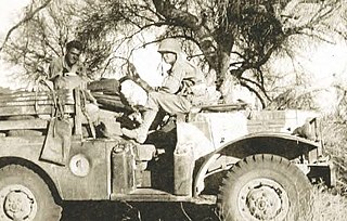
The Camp Horn was a sub camp of the US Army, Desert Training Center in Riverside County, California. The main headquarters for the Desert Training Center was Camp Young, this is where General Patton's 3rd Armored Division was stationed. Camp Horn was near Camp Hyder about 6 miles (9.7 km) miles west of Hyder, Arizona. Camp Horn was just north of the Gila River. Camp Horn was 54 miles (87 km) miles east of Yuma, Arizona. Most troop arrived at Camp Horn from the train station at Camp Hyder or the train station at Sentinel, Arizona south of the camp. Over 13,000 troops were trained at Camp Horn and Camp Hyder. The 81st Infantry Division trained at Camp Horn was from June 1943 to November 1943.
