
The Chiricahua Mountains massif is a large mountain range in southeastern Arizona which is part of the Basin and Range province of the west and southwestern United States and northwest Mexico; the range is part of the Coronado National Forest. The highest point, Chiricahua Peak, rises 9,759 feet (2,975 m) above sea level, approximately 6,000 feet (1,800 m) above the surrounding valleys. The range takes its name from the Chiricahua Apaches native to the region.

Aravaipa Canyon Wilderness is a 19,410 acres (7,850 ha) wilderness area located in the U.S. State of Arizona.

The Muggins Mountains is a mountain range in southwest Arizona east of Yuma, Arizona, northeast of the Gila Mountains, and east of the Laguna Mountains. The Castle Dome Mountains lie to the northeast across the broad Castle Dome Plain. The Muggins Mountains Wilderness occupies the southwest portion of the range.

The Peloncillo Mountains of Cochise County is a mountain range in northeast Cochise County, Arizona. A northern north-south stretch of the range extends to the southern region of Greenlee County on the northeast, and a southeast region of Graham County on the northwest. The north stretch of the Peloncillo's forms the border between the two counties. It lies east and northeast of the Willcox Playa, and the San Simon Valley.

The Peloncillo Mountains of Hidalgo County,, is a major 35-mile (56 km) long mountain range southwest of New Mexico's Hidalgo County, and also part of the New Mexico Bootheel region. The range continues to the northwest into Arizona as the Peloncillo Mountains of Cochise County, Arizona. The extreme southwest corner of the range also lies in Arizona. It is a linear range bordering the linear San Bernardino Valley of southeast Cochise County, Arizona.

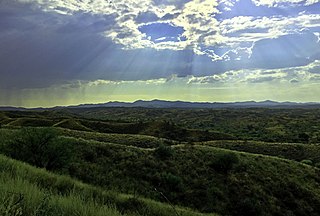
The Swisshelm Mountains are a small mountain range adjacent to the southwest corner of the Chiricahua Mountains of eastern Cochise County, Arizona. They are separated from the Pedrogosa Mountains to the southeast, the Chiricahuas to the northeast, and by Leslie Creek, bordering the south and east; the area is now notable for the Leslie Canyon National Wildlife Refuge.
The Pajarito Mountains is a small mountain range of western Santa Cruz County, Arizona, United States, that extend south into Sonora, Mexico. The range is adjacent the Atascosa Mountains at its north, with both ranges in the center of a north-south sequence of ranges called the Tumacacori Highlands. The Highlands have the Tumacacori Mountains at the north, and south of the U.S.-Mexico border, the Sierra La Esmeralda range. The Tumacacori Highlands are part of a regional conservancy study of "travel corridors" for cats, called Cuatro Gatos, Four Cats, for mountain lions, ocelot, bobcat, and jaguar.

The Harcuvar Mountains are a narrow mountain range in western-central Arizona, United States. The range lies just east of the north-south Colorado River, and south of the east-west, west-flowing Bill Williams River, from Alamo Lake.

The Buckskin Mountains is a mountain range in La Paz County, Arizona, United States. The range lies just east of the north–south Colorado River, and borders south of the east–west, west-flowing Bill Williams River.

Aravaipa Creek is a drainage between three mountain ranges in southwest Graham County, Arizona – the Galiuro Mountains, the Santa Teresa Mountains and the Pinaleno Mountains. These mountains are part of the high altitude Madrean Sky Islands located in southern Arizona and New Mexico in the United States, and northern Sonora and Chihuahua states in Mexico.

The Black Hills of Yavapai County are a large mountain range of central Arizona in southeast Yavapai County. It is bordered by the Verde Valley to the east. The northwest section of the range is bisected from the southeast section by Interstate 17, which is the main route connecting Phoenix to Sedona, Oak Creek Canyon, and Flagstaff. This bisection point is the approximate center of the mostly northwest by southeast trending range. The northwest section contains a steep escarpment on the northeast with the Verde Valley, the escarpment being the location of the fault-block that created the historic mining district at Jerome. The United Verde Mine was one of the largest copper mines in the United States, producing large quantities of copper, gold, silver and zinc.

The Big Burro Mountains are a moderate length 35-mile (56 km) long, mountain range located in central Grant County, New Mexico. The range's northwest-southeast 'ridgeline' is located 15 mi southwest of Silver City.

The Poachie Range is a moderate length mountain range and massif in southeast Mohave County, Arizona, and the extreme southwest corner of Yavapai County; the range also abuts the northeast corner of La Paz County. The Poachie Range massif is bordered by the south-flowing Big Sandy River on its west, and the west-flowing Santa Maria River on its south; both rivers converge at the Poachie Range's southwest at Alamo Lake in Alamo Lake State Park.

The Guadalupe Mountains of Hidalgo County are a 13 mi (21 km) long, sub–range in southwest Hidalgo County, New Mexico, adjacent the southeast border of Arizona's Cochise County. A small portion of the range is in Cochise County, namely the outlet of Guadalupe Canyon, famous for the Guadalupe Canyon Massacre. The very southern end of the range is also in the border region of Sonora, just north of Federal Highway 2.
The Date Creek Mountains are a short, arid range in southwest Yavapai County, Arizona. Congress is on its southeast foothills, and Wickenburg lies 15 mi (24 km) southeast.

The New River Mountains are a small 14-mi (23 km) long, mountain range in central Arizona, and on the north border of the Phoenix valley; the range is located on the southwest perimeter of the Arizona transition zone. The range is a sub-part of landforms extending south from the Black Hills of Yavapai County. Rivers and canyons border east and west; the south of the range is located in Maricopa County, the location of much of the Phoenix metropolitan area.
The Santa Maria Mountains are a 16-mi (26 km) long mountain range in central-northwest Arizona, and in northwest Yavapai County. The range lies in a region of mesas and mountain ranges in the northwest of Arizona's transition zone. The Santa Maria Mountains lie east of the transition zone's northwest perimeter, the parallel Aquarius and Mohon Mountains.

The Kanab Plateau is a 45-mile long plateau located at the north of the Grand Canyon in Arizona, United States. The plateau is adjacent west of the Kaibab Plateau of the North Rim, with a basin containing the Kanab Creek watershed in between. The basin is the site of the Kanab Creek Wilderness, with Snake Gulch at its north perimeter, and at the base of the Kanab Plateau, forming its southeast border.

Yellow Knolls, of Arizona, is a prominence in the Virgin River Gorge's east end, located in Mohave County, part of the Arizona Strip of northwest Arizona. Yellow Knolls is located on the north side of Interstate 15, and is also in the south of the Beaver Dam Mountains Wilderness.
The Peacock Mountains are a small, 26 mi (42 km) long mountain range in northwest Arizona, US. The range is a narrow sub-range, and an extension north, at the northeast of the Hualapai Mountains massif, which lies to the southwest. The range is defined by the Hualapai Valley to the northwest, and north and south-flowing washes on its east border, associated with faults and cliffs; the Cottonwood Cliffs are due east, and are connected to the Aquarius Cliffs southward at the west perimeter of the Aquarius Mountains; the cliffs are a result of the Aquarius Fault, which is an extension southward from the Grand Wash Cliffs and Grand Wash Fault which crosses the Colorado River at Lake Mead, and the west perimeter of the Grand Canyon/Colorado Plateau.


