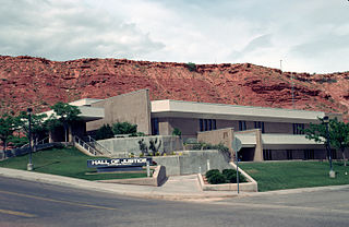
Washington County is a county in the southwestern corner of Utah, United States. As of the 2020 United States Census, the population was 180,279, making it the fifth-most populous county in Utah. Its county seat and largest city is St. George. The county was created in 1852 and organized in 1856. It was named after the first President of the United States, George Washington. In 2008, a Yahoo News article stated that Washington County had the fifth-highest job-growth rate in the United States. A portion of the Paiute Indian Reservation is in western Washington County. Washington County comprises the St. George, UT Metropolitan Statistical Area.

Mohave County is in the northwestern corner of the U.S. state of Arizona. As of the 2010 census, its population was 200,186. The county seat is Kingman, and the largest city is Lake Havasu City. It is the fifth largest county in the United States.

Lake Mead National Recreation Area is a U.S. national recreation area in southeastern Nevada and northwestern Arizona. Operated by the National Park Service, Lake Mead NRA follows the Colorado River corridor from the westernmost boundary of Grand Canyon National Park to just north of the cities of Laughlin, Nevada and Bullhead City, Arizona. It includes all of the eponymous Lake Mead as well as the smaller Lake Mohave – reservoirs on the river created by Hoover Dam and Davis Dam, respectively – and the surrounding desert terrain and wilderness.

The Big Maria Mountains are located in the southeastern part of the U.S. state of California, near the Colorado River and Arizona. The range lies between Blythe and Vidal, and west of U.S. Route 95 in California and east of Midland. The mountains are home to the Eagle Nest Mine and reach an elevation of 1,030 meters, (3,379 ft). A power line that runs from Parker Dam to Yuma, Arizona runs through the range. A smaller range, the Little Maria Mountains, lie to the west of the Big Marias.

The Beaver Dam Mountains Wilderness is a wilderness area located in northwestern Arizona and southwestern Utah, USA, within the arid Colorado Plateau region. The jagged mountains and gently sloping alluvial plain of the Beaver Dam Mountains straddle the border between the two states. The Wilderness contains some of the lowest elevation land in Utah, and includes a 13 miles (21 km) section of the Virgin River Gorge. The area comprises some 18,667 acres (7,554 ha), 15,000 acres (6,100 ha) of which in Arizona and approximately 3,667 acres (1,484 ha) in Utah. The area was designated Wilderness by the U.S. Congress in 1984 and is administered by the Bureau of Land Management.

Aravaipa Canyon Wilderness is a 19,410 acres (7,850 ha) wilderness area located in the U.S. State of Arizona.

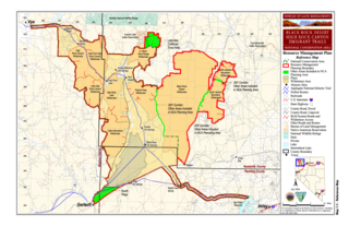
The Black Rock Desert–High Rock Canyon Emigrant Trails National Conservation Area is the federal land in northwestern Nevada, under the Bureau of Land Management-BLM management and protection, and the ten Wilderness Areas within it.

The Black Rock Desert Wilderness is a U S Wilderness Area in Nevada under the Bureau of Land Management. It is located in the east arm of the Black Rock Desert playa east of the Black Rock Range and west of the Jackson Mountains. The wilderness has a land area of 314,829 acres, or 1,274.1 km². It is the largest U.S. designated wilderness area that is managed solely by the Bureau of Land Management, and the largest that is not located within a National Forest, National Park, or National Wildlife Refuge. It is located within the Black Rock Desert – High Rock Canyon Emigrant Trails National Conservation Area, also managed by the BLM.

The Kiavah Wilderness is a federally designated wilderness area located in the Mojave Desert, Scodie Mountains, and southern Sierra Nevada in Kern County, California, United States. California State Route 178 connects the town of Lake Isabella to State Highway 14 in the east, crossing Walker Pass at the north boundary of the wilderness.

Galiuro Wilderness is a 76,317-acre (309 km2) wilderness area encompassing the mid to upper slopes of the Galiuro Mountains. It is located within the Safford Ranger District of the Coronado National Forest in the American state of Arizona. It is bordered on the south by the Redfield Canyon Wilderness.

Upper Burro Creek Wilderness is a 27,440-acre wilderness area located in Yavapai and Mohave Counties in the U.S. state of Arizona, approximately 10 miles (16 km) northwest of the town of Bagdad It is managed by the Bureau of Land Management.

The Sylvania Mountains Wilderness is a federally designated wilderness area located 30 miles (48 km) east of Bishop in the state of California. The wilderness is 18,677acres in size and is managed by the Bureau of Land Management (BLM). The California Desert Protection Act of 1994 created the Sylvania Mountains Wilderness and was added to the National Wilderness Preservation System. The wilderness is bordered by Nevada stateline on the east, Piper Mountain Wilderness on the west and Death Valley National Park to the south.

Aravaipa Creek is a drainage between three mountain ranges in southwest Graham County, Arizona – the Galiuro Mountains, the Santa Teresa Mountains and the Pinaleno Mountains. These mountains are part of the high altitude Madrean Sky Islands located in southern Arizona and New Mexico in the United States, and northern Sonora and Chihuahua states in Mexico.

Sand to Snow National Monument is a U.S. National Monument located in San Bernardino County and northern Riverside County, Southern California.

Gibraltar Mountain Wilderness is a protected wilderness area on the western edge of the Buckskin Mountains in the U.S. state of Arizona. Established in 1990 under the Arizona Desert Wilderness Act the area is managed by the Bureau of Land Management. This desert wilderness is primarily volcanic tuff crossed with deep canyons and sandy washes.

Grand Wash Cliffs Wilderness is a protected wilderness area in the Grand Canyon-Parashant National Monument in the U.S. state of Arizona. Established in 1984 under the Arizona Wilderness Act the area is managed by the Bureau of Land Management. This desert wilderness is a 12-mile stretch of the Grand Wash Cliffs encompassing escarpments, canyons, and sandstone buttes that make up the transition zone between the Colorado Plateau and the Basin and Range Province.

Signal Mountain Wilderness is a protected wilderness area centered around its namesake Signal Mountain, rising 1,200 feet (370 m) to a summit at 2,057 feet (627 m) in the Gila Bend Mountains in the U.S. state of Arizona. Established in 1990 under the Arizona Desert Wilderness Act, the area is managed by the Bureau of Land Management. The desert wilderness is made up of steep canyons, winding arroyos, and volcanic peaks within a Sonoran Desert ecosystem.

Table Top Wilderness is a protected wilderness area centered around its namesake Table Top Mountain, a summit of 4,373 feet in the Table Top Mountains in the U.S. state of Arizona. Established in 1990 under the Arizona Desert Wilderness Act the area is managed by the Bureau of Land Management. It is located in the Sonoran Desert National Monument south of Interstate 8 between the towns of Casa Grande and Gila Bend. The flat-topped mesa rises from the desert floor in Vekol Valley to the east surrounded by smaller canyons and desert washes with views of the desert plain in all directions. There are two established trails in the wilderness area, one of which leads to the summit.

Mount Nutt Wilderness is a protected wilderness area in the central part of the Black Mountains in the U.S. state of Arizona. It was established in 1990 under the Arizona Desert Wilderness Act, and it is managed by the Bureau of Land Management. This desert wilderness sits among a maze of desert canyons and steep mesas, surrounded by volcanic plugs.

White Canyon Wilderness is a protected wilderness area in the southeastern portion of the Mineral Mountains in the U.S. state of Arizona. Established in 1990 under the Arizona Desert Wilderness Act the area is managed by the Bureau of Land Management.


