Sunset Mountains (Arizona)

Last updated
East Sunset Mountain
Highest point
Elevation 6,853 ft (2,089 m)  NAVD 88 [1]
Prominence 980 ft (300 m) [1]
Coordinates 34°50′27″N110°53′59″W / 34.8408557°N 110.8998581°W / 34.8408557; -110.8998581 Coordinates: 34°50′27″N110°53′59″W / 34.8408557°N 110.8998581°W / 34.8408557; -110.8998581 [2]
Geography
Location Coconino County, Arizona, U.S.
Topo map USGS West Sunset Mountain
West Sunset Mountain
Highest point
Elevation 6,613 ft (2,016 m)  NAVD 88 [3]
Prominence 980 ft (299 m) [3]
Coordinates 34°52′33″N110°56′22″W / 34.8758542°N 110.9395816°W / 34.8758542; -110.9395816 [4]
Geography
Location Coconino County, Arizona, U.S.
Topo map USGS Sunset Pass

The Sunset Mountains in Coconino County, Arizona are two a small mesas known as East Sunset Mountain and West Sunset Mountain, located southeast of Winslow. State Route 87 passes between the mountains.

Related Research Articles

Four Peaks Landform near Phoenix, Arizona

Four Peaks is a prominent landmark on the eastern skyline of Phoenix. Part of the Mazatzal Mountains, it is located in the Four Peaks Wilderness in the Tonto National Forest, 40 miles (64 km) east-northeast of Phoenix. In winter, Four Peaks offers much of the Phoenix metro area a view of snow-covered peaks. Four Peaks is the site of an amethyst mine that produces top-grade amethyst.

Gu Achi Peak Landform in Pima County, Arizona

Gu Achi Peak is a mountain in the Santa Rosa Mountains of Arizona. It is on the Tohono O'odham Indian Reservation, about 56 miles (90 km) west of Tucson. Gu Achi Peak can be translated as 'big ridge'. In precolonial times it was the central territory of the Totokwan group of the O'odham, and it may have served as the ceremonial center for the northern O'odham groups.

East End is a mountain located at the northeastern end of the McDowell Mountains and about 24 miles (39 km) north northeast of Scottsdale, Arizona. Its summit is the highest point in the range, at 4,069 feet (1,240 m). The mountain is mostly covered in rocky boulders, and is the site of the ancient Marcus Landslide.

Mount Baldy (Arizona) Mountain in Apache County, Arizona, United States

Mount Baldy is a mountain in eastern Arizona in the United States. With a summit elevation of 11,409 feet (3,477 m), the peak of Mount Baldy rises above the tree line and is left largely bare of vegetation, lending the mountain its current name. The Mount Baldy Wilderness occupies the eastern slope of the mountain and is managed by the Apache-Sitgreaves National Forest.

Chiricahua Peak Mountain in Cochise County, Arizona

Chiricahua Peak is the name of a 9,763 feet (2,976 m) peak located in the Chiricahua Mountains of southeastern Arizona, located about 35 miles (56 km) north of the United States–Mexico border. It is the highest summit in the Chiricahua Mountains and the highest point in Cochise County.

Thimble Peak Landform in Pima County, Arizona

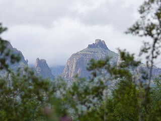
Thimble Peak is a well-known landmark in the Santa Catalina Mountains north of Tucson, Arizona. Thimble Peak rises from the foothills on the south side of the range. To its east is Bear Canyon, while to its west is Sabino Canyon. The peak is in the Pusch Ridge Wilderness on the Coronado National Forest.

Mount Tipton is a mountain in northwestern Arizona in the United States. With a summit elevation of 7,153 feet (2,180 m), it is the tallest mountain in the Cerbat Mountains which border Kingman on the north, and is the high point of the Mount Tipton Wilderness which comprises the entirety of the northern portion of the Cerbat Mountains. The community of Dolan Springs lies west at the base of Mount Tipton at the northwest side of the Cerbat Range.

Ajo Peak is a mountain peak in southern Arizona, in the north-and-east Sonoran Desert. Two peaks are nearby, Cardigan Peak at 2,922 feet (891 m) and North Ajo Peak 2,776 feet (846 m).

OLeary Peak Extinct Pleistocene lava dome volcano in Arizona

O'Leary Peak is an extinct Pleistocene lava dome volcano within the San Francisco volcanic field, north of Flagstaff, Arizona, and to the northwest of Sunset Crater National Monument. A fire lookout tower was built on a subsidiary eastern peak. It has an elevation of 8,919 feet (2,719 m).

Sugarloaf Mountain (Arizona) Landform in Maricopa County, Arizona

Sugarloaf Mountain, of Arizona is the tallest peak in the arid, low elevation Hummingbird Springs Wilderness of northwest Maricopa County, and about 65 miles (105 km) west of Phoenix. It rises in the Tonopah Desert about 10 miles (16 km) northwest of the Belmont Mountains. Hummingbird Springs Wilderness is just north of the Big Horn Mountains Wilderness. The two are separated only by a jeep trail that leads to Hummingbird Springs.

Mount Glenn, is in the Coronado National Forest, about 75 miles (121 km) east of Tucson, Arizona. The summit, in Cochise County, is the highest point in the Dragoon Mountains and is a popular local hiking destination.

Thompson Peak (Arizona) Mountain in Maricopa County, Arizona

Thompson Peak is located in the McDowell Mountains, the summit being 20 miles (32 km) to the northeast of Phoenix, Arizona. Its height is 3,984 feet (1,214 m). Thompson Peak has amateur and Maricopa County government radio towers on the summit, accessible via a service road from Fountain Hills.

West and East Mitten Buttes Landform in Arizona, United States

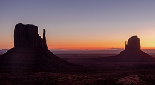
The West and East Mitten Buttes are two buttes in the Monument Valley Navajo Tribal Park in northeast Navajo County, Arizona. When viewed from the south, the buttes appear to be two giant mittens with their thumbs facing inwards.

Mae West Peaks Landform in Cochise County, Arizona

Mae West Peaks is a pair of summits in Cochise County, Arizona. The taller of the two was formerly known as Lime Peak and the elevation and coordinates in the infobox refer to this peak. They are in the Little Dragoon Mountains, northwest of Texas Canyon and 3.3 miles (5.3 km) west-southwest of the ghost town of Johnson, Arizona.

Lime Peak (Arizona) Landform in Cochise County, Arizona

Lime Peak is a summit in Cochise County, Arizona, north of Interstate 10 between Benson and Willcox and 6.6 miles (11 km) northwest of Dragoon, Arizona. It is one of three named peak in the Little Dragoon Mountains. Two of the peaks are named the Mae West Peaks since there appearance was thought to be reminiscent of the figure of the actress Mae West.

References

  1. 1 2 "East Sunset Mountain, Arizona". Peakbagger.com. Retrieved 2014-02-08.
  2. "East Sunset Mountain". Geographic Names Information System . United States Geological Survey . Retrieved 2014-02-08.
  3. 1 2 "West Sunset Mountain, Arizona". Peakbagger.com. Retrieved 2014-02-08.
  4. "West Sunset Mountain". Geographic Names Information System . United States Geological Survey . Retrieved 2014-02-08.