Phoenix is the capital and most populous city of the U.S. state of Arizona, with 1,662,607 residents as of 2024. It is the fifth-most populous city in the United States and the most populous state capital in the country.
Avondale is a city in Maricopa County, Arizona, United States, adjacent to Phoenix. As of the 2020 census, the population of the city was 89,334, up from 76,238 in 2010 and 35,883 in 2000.

Cave Creek is a town in Maricopa County, Arizona, United States. It is part of the Phoenix metropolitan area. As of the 2020 census, the population of the town was 4,892.

Scottsdale is a city in the eastern part of Maricopa County, Arizona, United States, and is part of the Phoenix metropolitan area. Named Scottsdale in 1894 after its founder Winfield Scott, a retired U.S. Army chaplain, the city was incorporated in 1951 with a population of 2,000. At the 2020 census, the population was 241,361, which had grown from 217,385 in 2010. Its slogan is "The West's Most Western Town". Over the past two decades, it has been one of the fastest growing cities and housing markets in the United States.
Glendale Union High School District No. 205 is a school district headquartered in Glendale, Arizona, United States.
Sunnyslope High School is in the Glendale Union High School District in Phoenix, Arizona and offers courses for grades 9–12. It first opened in 1953.
The Washington Elementary School District provides education for more than 25,300 students in the north central Phoenix and east Glendale areas of Arizona. With 32 schools, WESD is the largest elementary school district in Arizona.
The Arizona Rugby Union (ARU) is the Local Area Union (LAU) for rugby union teams in Arizona. ARU is part of the Southern California Rugby Football Union (SCRFU), which is one of several Geographical Unions (GUs) that comprise USA Rugby.
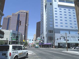
The Central Avenue Corridor is a significant stretch of north–south Central Avenue in Phoenix, Arizona. Roughly bounded by Camelback Road to its north, and McDowell Road to its south, this is one of Phoenix's most vital and heavily trafficked stretches of roads. It is also one of the region's largest centers of employment, with nearly 60,000 people being employed within a three-mile (5 km) radius of this swath of Central Avenue. Major employers here include major banks and financial institutions, hi-tech companies, and several significant law firms and government agencies.

Located in South Mountain Park in Phoenix, Arizona, Scorpion Gulch was built as a home and store by William Lunsford. Lunsford's store sold curios, Indigenous-made items, sodas, and candy. It was still in operation in 1966, when Lunsford was 75. In the 1970s, it became a bar. According to the Phoenix Historic Property Register, Scorpion Gulch was built in 1936, and was first listed on the historic preservation register in October 1990. Historical photographs show a sign on the original building entitled, "South Mountain Trading Post", under which jewelry, Indian curios, and leather goods are advertised.

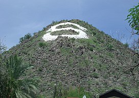
The Sunnyslope community is an established neighborhood within the borders of the city of Phoenix, Arizona. The geographic boundaries are 19th Avenue to the west, Cactus Road to the north, 16th Street to the east, and Northern Avenue to the south. This area covers approximately nine square miles (23 km2) and is divided into nine census tracts. The Sunnyslope community is included in parts of three zip code areas: 85020, 85021 and 85029.

Phoenix Union High School (PUHS) was a high school that was part of the Phoenix Union High School District in downtown Phoenix, Arizona, one of five high school-only school districts in the Phoenix area. Founded in 1895 and closed in 1982, the school consisted of numerous buildings on a campus which by 1928 consisted of 18 acres.

The Deer Valley Petroglyph Preserve, formerly known as the Deer Valley Rock Art Center, is a 47-acre nature preserve featuring over 1500 Hohokam, Patayan, and Archaic petroglyphs visible on 500 basalt boulders in the Deer Valley area of Phoenix, Arizona. In 1980, the US Army Corps of Engineers contracted J. Simon Bruder to conduct an archaeological investigation prior to the construction of the Adobe Dam at the Hedgpeth Hills. The petroglyphs are between 500 and 5,000 years old. The site was listed on the National Register of Historic Places in 1984, and it was also listed with the Phoenix Points of Pride. The preserve and museum are operated by the ASU College of Liberal Arts and Sciences's School of Human Evolution and Social Change.

El Cid Castle was a landmark structure located on the opposite side of the western boundary of Sunnyslope, Arizona. The controversial castle, built by the late Dr. Kenneth Hall, was supposed to be a bowling alley which resembled a Moorish Castle. Construction on the structure began in 1963 and was completed in 1980.

The Phoenix Historic Property Register is the official listing of the historic and prehistoric properties in the city of Phoenix, the capital and largest city, of the U.S. state of Arizona. The city's register includes most or all places in Phoenix listed on the National Register of Historic Places and many more of local significance.

Greenwood Memory Lawn Mortuary & Cemetery is the official name given to a cemetery located at 2300 West Van Buren Street in Phoenix, Arizona owned by Dignity Memorial. The cemetery, which resulted as a merger of two historical cemeteries, Greenwood Memorial Park and Memory Lawn Memorial Park, is the final resting place of various notable former residents of Arizona. Pioneers, governors, congressman, government officials, journalists, race car drivers, soldiers, actors and actresses are among the many notable decedents who are interred in the cemetery.
 Phoenix Historic Property Register marker at the summit trailhead
 View from the trail
 Northern skyline, downtown Phoenix in foreground, "S" mountain clearly visible on high resolution.