Central City | |
---|---|
Central City Village | |
Country | United States |
State | Arizona |
County | Maricopa |
City | Phoenix |
Area | |
• Total | 10 sq mi (30 km2) |
Population (2010) [2] | |
• Total | 58,161 |
• Density | 5,800/sq mi (2,200/km2) |
Website | www |
Central City Village is the urban village of Phoenix, Arizona, that includes the downtown area of the city. As of 2010, it had a population of 58,161 residents.
As defined by the boundaries, Central City Village has an area of roughly 10 square miles. This includes not only Downtown, but the close vicinity and the Sky Harbor area directly east. The village is bounded by McDowell Road and the Grand Canal to the north and northeast, the border with Tempe to the east, the Salt River to the south, and 19th Avenue/I-17 to the west.
Because of its location at the historic center of Phoenix, there are many old homes and buildings located in the Central City Village that convey the history of Phoenix. Downtown, which includes the larger commercial and government buildings, as well as sports venues such as Footprint Center and Chase Field, is the core of the village and the city of Phoenix. Because of this, Central City Village is almost unique, in that it has a much more urban environment than the other, more suburban, villages of Phoenix.
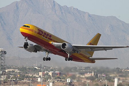
The village also includes Sky Harbor International Airport, the busiest airport in Arizona and among the busiest in the nation, which provides domestic air travel, as well as international travel.
Phoenix is the capital and most populous city in the American state of Arizona, with 1,608,139 residents as of 2020. It is the fifth-most populous city in the United States, and one of only two state capitals with a population of more than one million residents, along with Austin.
Buckeye is a city in Maricopa County, Arizona, United States, and is the westernmost suburb in the Phoenix metropolitan area. As of the 2020 census the population was 91,502, up from 50,876 in 2010 and 6,537 in 2000. It was the fastest-growing city in the United States for both 2017 and 2018.
Chandler is a city in Maricopa County, Arizona, United States, and a suburb within the Phoenix-Mesa-Chandler Metropolitan Statistical Area (MSA). It is bordered to the north and west by Tempe, to the north by Mesa, to the west by Phoenix, to the south by the Gila River Indian Community, and to the east by Gilbert. As of the 2020 census, the population of Chandler was 275,987, up from 236,123 at the 2010 census.
Scottsdale is a city in the eastern part of Maricopa County, Arizona, United States, and is part of the Phoenix metropolitan area. Named Scottsdale in 1894 after its founder Winfield Scott, a retired U.S. Army chaplain, the city was incorporated in 1951 with a population of 2,000. As of the 2020 census, the population was 241,361, up from 217,385 in 2010. Its slogan is "The West's Most Western Town". It has been one of the fastest growing cities in the United States over the past decades.
Phoenix Sky Harbor International Airport is a civil-military public airport 3 miles east of downtown Phoenix, in Maricopa County, Arizona, United States. It is Arizona's largest and busiest airport, and among the largest commercial airports in the United States; in 2021, PHX was the 8th-busiest airport in the United States and 11th-busiest in the world. The airport serves as a hub for American Airlines and a base for Southwest Airlines. In 2021, Southwest carried nearly 35% of all PHX passengers, making it the airport's largest carrier and surpassing American for the first time in years.
The Phoenix Metropolitan Area – also the Valley of the Sun, the Salt River Valley, or Metro Phoenix – is the largest metropolitan area in the Southwestern United States, centered on the city of Phoenix, that includes much of the central part of Arizona. The United States Office of Management and Budget designates the area as the Phoenix-Mesa-Scottsdale Metropolitan Statistical Area (MSA), defining it as Maricopa and Pinal counties. As of the 2020 census, Metro Phoenix had 4,845,832 residents, making it the 11th largest metropolitan area in the nation by population. It anchors the Arizona Sun Corridor megaregion along with the second most populous metropolitan area in the state, the Tucson metropolitan area. The gross domestic product of the Phoenix Metropolitan Area was $255 billion in 2018, 16th largest amongst metro areas in the United States.
The South Mountains, known locally as simply South Mountain, is a mountain range in central Arizona in south Phoenix, Arizona. It is on public land managed by the city of Phoenix as South Mountain Park.
Downtown Memphis, Tennessee is the central business district of Memphis, Tennessee and is located along the Mississippi River between Interstate 40 to the north, Interstate 55 to the south and I-240 to the east, where it abuts Midtown Memphis.
North/Northwest Phoenix is a region in the city of Phoenix, Arizona. While the area with this name has no official separate status, it usually refers to the Urban Villages of Paradise Valley, North Mountain, Deer Valley, Desert View, and North Gateway.
Valley Metro Rail is a 28.2-mile (45 km) light rail line serving the cities of Phoenix, Tempe, and Mesa in Arizona, USA. The network, which is part of the Valley Metro public transit system, began operations on December 27, 2008. The line carried 49,416 passengers per day in 2016, making it the 14th busiest light rail system in the country.
Encanto Village is one of the 15 Urban villages that make up the City of Phoenix, in Arizona. The village includes the city's midtown and uptown districts, as well as the popular Encanto neighborhood, its namesake. In 2010, Encanto had a population of 54,614 residents.
The transportation system of Arizona comprises car, rail, air, bus, and bicycle transport.
Phoenix–Mesa Gateway Airport, formerly Williams Gateway Airport (1994–2008) and Williams Air Force Base (1948–1993), is an international airport in the southeastern area of Mesa, Arizona, 20 miles southeast of Phoenix, in Maricopa County. The airport, owned and operated by the Phoenix–Mesa Gateway Airport Authority, is a reliever airport for Phoenix Sky Harbor International Airport. It is a base for Allegiant Air.
The metropolitan area of Phoenix in the U.S. state of Arizona contains one of the nation's largest and fastest-growing freeway systems, boasting over 1,405 lane miles (2,261 km) as of 2005.
The Central Avenue Corridor is a significant stretch of north–south Central Avenue in Phoenix, Arizona. Roughly bounded by Camelback Road to its north, and McDowell Road to its south, this is one of Phoenix's most vital and heavily trafficked stretches of roads. It is also one of the region's largest centers of employment, with nearly 60,000 people being employed within a three-mile (5 km) radius of this swath of Central Avenue. Major employers here include major banks and financial institutions, hi-tech companies, and several significant law firms and government agencies.
Many arterial roads in the Phoenix metropolitan area have the same name in multiple cities or towns. Some roads change names or route numbers across town borders, resulting in occasional confusion. For example, the road known as Apache Boulevard in Tempe continues east as Main Street in neighboring Mesa and then as Apache Trail in Apache Junction. Although Broadway Road maintains the same name through Goodyear, Avondale, Phoenix, Tempe, Mesa, and Apache Junction, each town uses a different reference point for address numbers.
Valley Metro Bus is a transit bus system for public transport in Maricopa County, Arizona, United States. Buses are operated by private companies contracted by Valley Metro and the City of Phoenix. Service currently operates throughout the broader Phoenix Metropolitan Area. All buses have wheelchair ramps or lifts, and except for paratransit vehicles, all buses have bike racks.
Deer Valley or Deer Valley Village is one of the 15 urban villages that make up Phoenix, Arizona, United States. As of 2010, the population was 165,656, 25% of whom were under 18 years of age. The origin of the name is unclear; it first appeared on a 1921 General Land Office map of the area describing the valley created by Skunk Creek.
The following is a timeline of the history of the city of Phoenix, Arizona, United States.
DWL Architects + Planners Inc., is an architecture and planning firm headquartered in Phoenix, Arizona. The firm was founded in 1949 by Frederick Penn Weaver and Richard E. Drover as the firm Weaver & Drover. It later became Drover, Welch & Lindlan Architects and was then shortened to DWL. The firm has designed many noteworthy buildings throughout the state of Arizona.
{{cite web}}
: CS1 maint: archived copy as title (link){{cite web}}
: CS1 maint: archived copy as title (link)