
The Colorado Plateau, also known as the Colorado Plateau Province, is a physiographic and desert region of the Intermontane Plateaus, roughly centered on the Four Corners region of the southwestern United States. This province covers an area of 336,700 km2 (130,000 mi2) within western Colorado, northwestern New Mexico, southern and eastern Utah, northern Arizona, and a tiny fraction in the extreme southeast of Nevada. About 90% of the area is drained by the Colorado River and its main tributaries: the Green, San Juan, and Little Colorado. Most of the remainder of the plateau is drained by the Rio Grande and its tributaries.

The Harquahala Mountains are the highest mountain range in southwestern Arizona, United States and are located southwest of the towns of Aguila and Wenden. The name originated from the Yavapai 'ʼHakhe:la", which means "running water". The range is oriented from northeast to southwest and is approximately 32 km long and 20 km at its widest point. At the northeast are two prominent peaks, Eagle Eye Peak and Eagle Eye Mountain. One has a natural opening or bridge through it appearing as an eye high up, and is the namesake for the peaks and Aguila. The highest point, Harquahala Peak, rises to 5,681 ft. Socorro Peak, 3270 ft, is at the southwest end of the range.

The Carrizo Mountains is a small, mostly circular mountain range 15 to 20 km in diameter located on the Colorado Plateau in northeastern Arizona. The range is about 20 km (12 mi) southwest of the Four Corners. The highest summit, Pastora Peak, is 2,869 m (9,413 ft) in elevation, whereas elevations on the surrounding plateau are near 1,800 m (5,900 ft).

Mining in Western Australia, together with the petroleum industry in the state, accounted for 94% of the State's and 41% of Australia's income from total merchandise exports in 2018–19. The state of Western Australia hosted 127 principal mining projects and hundreds of smaller quarries and mines. The principal projects produced more than 99 per cent of the industry's total sales value.
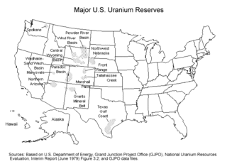
Uranium mining in the United States produced 173,875 pounds (78.9 tonnes) of U3O8 in 2019, 88% lower than the 2018 production of 1,447,945 pounds (656.8 tonnes) of U3O8 and the lowest US annual production since 1948. The 2019 production represents 0.3% of the anticipated uranium fuel requirements of the US's nuclear power reactors for the year.
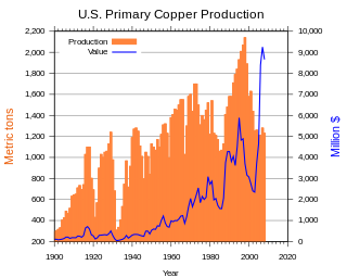
Copper mining in the United States has been a major industry since the rise of the northern Michigan copper district in the 1840s. In 2017 the United States produced 1.27 million metric tonnes of copper, worth $8 billion, making it the world's fourth largest copper producer, after Chile, China, and Peru. Copper was produced from 23 mines in the US. Top copper producing states in 2014 were Arizona, Utah, New Mexico, Nevada, and Montana. Minor production also came from Idaho, and Missouri. As of 2014, the US had 45 million tonnes of known remaining reserves of copper, the fifth largest known copper reserves in the world, after Chile, Australia, Peru, and Mexico.

Uranium mining in Colorado, United States, goes back to 1872, when pitchblende ore was taken from gold mines near Central City, Colorado. The Colorado uranium industry has seen booms and busts, but continues to this day. Not counting byproduct uranium from phosphate, Colorado is considered to have the third largest uranium reserves of any US state, behind Wyoming and New Mexico.

Uranium mining in Wyoming was formerly a much larger industry than it is today. Wyoming once had many operating uranium mines, and still has the largest known uranium ore reserves of any state in the U.S. At the end of 2008, the state had estimated reserves dependent on price: 539 million pounds of uranium oxide at $50 per pound, and 1,227 million pounds at $100 per pound.
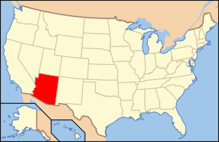
Copper mining in Arizona, a state of the United States, has been a major industry since the 19th century. In 2007 Arizona was the leading copper-producing state in the US, producing 750 thousand metric tons of copper, worth a record $5.54 billion. Arizona's copper production was 60% of the total for the United States. Copper mining also produces gold and silver as byproducts. Byproduct molybdenum from copper mining makes Arizona the nation's second-largest producer of that metal. Although copper mineralization was found by the earliest Spanish explorers of Arizona, the territory was remote, and copper could seldom be profitably mined and shipped. Early Spanish, Mexican, and American prospectors searched for gold and silver, and ignored copper. It was not until the completion of the Southern Pacific Railroad in 1876 that copper became broadly economic to mine and ship to market.

Uranium mining in Utah, a state of the United States, has a history going back more than 100 years. Uranium mining started as a byproduct of vanadium mining about 1900, became a byproduct of radium mining about 1910, then back to a byproduct of vanadium when the radium price fell in the 1920s. Utah saw a uranium boom in the late 1940s and early 1950s, but uranium mining declined in the 1980s. Since 2001 there has been a revival of interest in uranium mining, as a result of higher uranium prices.

Uranium ore deposits are economically recoverable concentrations of uranium within the Earth's crust. Uranium is one of the more common elements in the Earth's crust, being 40 times more common than silver and 500 times more common than gold. It can be found almost everywhere in rock, soil, rivers, and oceans. The challenge for commercial uranium extraction is to find those areas where the concentrations are adequate to form an economically viable deposit. The primary use for uranium obtained from mining is in fuel for nuclear reactors.

Uranium mining in Arizona has taken place since 1918. Prior to the uranium boom of the late 1940s, uranium in Arizona was a byproduct of vanadium mining of the mineral carnotite.
The mineral industry of Kazakhstan is one of the most competitive and fastest growing sectors of the country. Kazakhstan ranks second to Russia among the countries of the CIS in its quantity of mineral production. It is endowed with large reserves of a wide range of metallic ores, industrial minerals, and fuels, and its metallurgical sector is a major producer of a large number of metals from domestic and imported raw materials. In 2005, its metal mining sector produced bauxite, chromite, copper, iron, lead, manganese, and zinc ores, and its metallurgical sector produced such metals as beryllium, bismuth, cadmium, copper, ferroalloys, lead, magnesium, rhenium, steel, titanium, and zinc. The country produced significant amounts of other nonferrous and industrial mineral products, such as alumina, arsenic, barite, gold, molybdenum, phosphate rock, and tungsten. The country was a large producer of mineral fuels, including coal, natural gas, oil, and uranium. The country's economy is heavily dependent on the production of minerals. Output from Kazakhstan's mineral and natural resources sector for 2004 accounted for 74.1% of the value of industrial production, of which 43.1% came from the oil and gas condensate extraction. In 2004, the mineral extraction sector accounted for 32% of the GDP, employed 191,000 employees, and accounted for 33.1% of capital investment and 64.5% of direct foreign investment, of which 63.5% was in the oil sector. Kazakhstan's mining industry is estimated at US$29.5 billion by 2017.

The Kintyre uranium project is located 60 km south of the Telfer gold mine and 260 km northeast of Newman at the western edge of the Great Sandy Desert in the East Pilbara region of Western Australia.

Hathor Exploration Limited is a uranium exploration company based in Vancouver, British Columbia, Canada. Its exploration office is located in Saskatoon, Saskatchewan, Canada. Hathor's exploration projects concentrate on properties within the Athabasca Basin of Northern Saskatchewan, Canada.
The Yeelirrie uranium project is a uranium deposit located approximately 70 km southwest of Wiluna, in the Mid West region of Western Australia. The name Yeelirrie is taken from the local sheep station.
The world's largest producer of uranium is Kazakhstan, which in 2019 produced 43% of the world's mining output. Canada was the next largest producer with a 13% share, followed by Australia with 12%. Uranium has been mined in every continent except Antarctica.
The Artillery Peak mine is a mine located in the western United States, about 3 miles (4.8 km) north of Alamo Lake in Mohave County, Arizona. Artillery Peak represents one of the largest manganese reserves in the United States, with estimated reserves of 159 million tons of manganese ore graded 3.9% manganese metal.
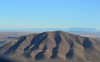
Round Top Mountain is a mountain located at the western end of the Sierra Blanca area in Hudspeth County, Texas near the town of Sierra Blanca. The area includes the Finlay Mountains, Triple Hill, and Sierra Blanca quadrangles as well as parts of the Fort Quitman and McNary quadrangles. Round Top Mountain is known for containing deposits of beryllium as well as the largest deposit of heavy rare-earth elements in the United States.
The geology of Arizona began to form in the Precambrian. Igneous and metamorphic crystalline basement rock may have been much older, but was overwritten during the Yavapai and Mazatzal orogenies in the Proterozoic. The Grenville orogeny to the east caused Arizona to fill with sediments, shedding into a shallow sea. Limestone formed in the sea was metamorphosed by mafic intrusions. The Great Unconformity is a famous gap in the stratigraphic record, as Arizona experienced 900 million years of terrestrial conditions, except in isolated basins. The region oscillated between terrestrial and shallow ocean conditions during the Paleozoic as multi-cellular life became common and three major orogenies to the east shed sediments before North America became part of the supercontinent Pangaea. The breakup of Pangaea was accompanied by the subduction of the Farallon Plate, which drove volcanism during the Nevadan orogeny and the Sevier orogeny in the Mesozoic, which covered much of Arizona in volcanic debris and sediments. The Mid-Tertiary ignimbrite flare-up created smaller mountain ranges with extensive ash and lava in the Cenozoic, followed by the sinking of the Farallon slab in the mantle throughout the past 14 million years, which has created the Basin and Range Province. Arizona has extensive mineralization in veins, due to hydrothermal fluids and is notable for copper-gold porphyry, lead, zinc, rare minerals formed from copper enrichment and evaporites among other resources.


