Arizona Village is a census-designated place (CDP) on the Fort Mojave Indian Reservation in Mohave County, Arizona, United States. The population was 1,057 at the 2020 census, up from 946 in 2010 and 351 in 2000.

Mesquite Creek is an unincorporated community and census-designated place (CDP) in Mohave County, Arizona, United States. The population was 403 at the 2020 census.

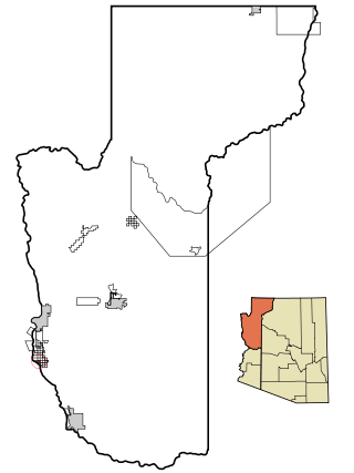
Mohave Valley is an unincorporated community and census-designated place (CDP) in Mohave County, Arizona, United States. The population was 2,693 at the 2020 census. It is geographically connected to Needles, California, Fort Mohave and Bullhead City.
Mojave Ranch Estates is an unincorporated community and census-designated place (CDP) in Mohave County, Arizona, United States. The population was 53 as of the 2020 census.

Willow Valley is an unincorporated community and census-designated place (CDP) in Mohave County, Arizona, United States. The population was 1,059 as of the 2020 census.

The Fort Mohave Indian Reservation is an Indian reservation along the Colorado River, currently encompassing 23,669 acres (95.79 km2) in Arizona, 12,633 acres (51.12 km2) in California, and 5,582 acres (22.59 km2) in Nevada. The reservation is home to approximately 1,100 members of the federally recognized Fort Mojave Indian Tribe of Arizona, California, and Nevada, a federally recognized tribe of Mohave people.

The Mohave Valley is a valley located mostly on the east shore of the south-flowing Colorado River in northwest Arizona. The valley extends into California's San Bernardino County; the northern side of the valley extends into extreme southeast Clark County, Nevada. The main part of the valley lies in southwest Mohave County, Arizona and is at the intersection of the southeast Mojave and northwest Sonoran deserts.

The Mojave Road, also known as Old Government Road, is a historic route and present day dirt road across what is now the Mojave National Preserve in the Mojave Desert in the United States. This rough road stretched 147 miles (237 km) from Beale's Crossing, to Fork of the Road location along the north bank of the Mojave River where the old Mojave Road split off from the route of the Old Spanish Trail/Mormon Road.

KFLG-FM is a radio station broadcasting a country music format. Licensed to Big River, California, United States, it serves the entire Tri-State area including Lake Havasu City; Kingman, Arizona; Needles, California; Laughlin, Nevada; and Bullhead City, Arizona. The station is currently owned by Cameron Broadcasting, Inc.
The Sacramento Valley of northwestern Arizona is a north–south trending valley west and southwest of Kingman in Mohave County. The valley lies just east of the southern section of the Black Mountains. Interstate 40 in Arizona traverses the valley north–south.
The Black Mesa of northwestern Arizona is the extreme southern section of the Black Mountains.
Stellantis North America, more commonly known as Chrysler, operates proving grounds around North America for development and validation testing of new vehicles.

Havasu Lake is an unincorporated community in San Bernardino County, California, United States, located on Lake Havasu on the Chemehuevi Reservation in the Mojave Desert. The community serves as the seat of the tribal government of the Chemehuevi Indian Tribe and is home to the Havasu Landing Casino.

The Plomosa Mountains are a mountain range in La Paz County, Arizona, running generally south of Bouse, Arizona near the Arizona/California border. Quartzsite lies to the west across the La Posa Plain. The Harcuvar Mountains and Little Harquahala Mountains lie to the east across the Ranegras Plain. The New Water Mountains lie to the southeast beyond Black Mesa.
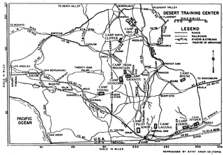
The Desert Training Center (DTC), also known as California–Arizona Maneuver Area (CAMA), was a World War II training facility established in the Mojave Desert and Sonoran Desert, largely in Southern California and Western Arizona in 1942.
Dutch Flat of Arizona is a valley south of the Sacramento Valley and Interstate 40 in southern Mohave County.
Powell was a railroad station and settlement in Mohave County, Arizona, United States from 1883 to 1890.
Beal was a railroad station on the Atlantic and Pacific Railroad line between Needles, California and Topock, Arizona from 1889. It was located 5 miles north on the railroad line to Needles from Mellen.
Eastbridge was a railroad station on the east bank of the Colorado River in Mohave County, Arizona, United States. It was located at the site of the first bridge the Atlantic and Pacific Railroad built across that river, three miles southeast of Needles, in San Bernardino County, California.
McConnico is an unincorporated community and census-designated place (CDP) in Mohave County, Arizona, United States. The population was 63 at the 2020 census.
