
Mohave County is in the northwestern corner of the U.S. state of Arizona. As of the 2020 census, its population was 213,267. The county seat is Kingman, and the largest city is Lake Havasu City. It is the fifth largest county in the United States.

The Verde River is a major tributary of the Salt River in the U.S. state of Arizona. It is about 170 miles (270 km) long and carries a mean flow of 602 cubic feet per second (17.0 m3/s) at its mouth. It is one of the largest perennial streams in Arizona.

The Mohave Valley is a valley located mostly on the east shore of the south-flowing Colorado River in northwest Arizona. The valley extends into California's San Bernardino County; the northern side of the valley extends into extreme southeast Clark County, Nevada. The main part of the valley lies in southwest Mohave County, Arizona and is at the intersection of the southeast Mojave and northwest Sonoran deserts.

Lake Havasu is a large reservoir formed by Parker Dam on the Colorado River, on the border between San Bernardino County, California and Mohave County, Arizona. Lake Havasu City sits on the Arizonan side of the lake with its Californian counterpart of Havasu Lake directly across the lake. The reservoir has an available capacity of 619,400 acre-feet (764,000,000 m3). The concrete arch dam was built by the United States Bureau of Reclamation between 1934 and 1938. The lake's primary purpose is to store water for pumping into two aqueducts. Prior to the dam construction, the area was home to the Mojave people. The lake was named after the Mojave word for blue. In the early 19th century, it was frequented by beaver trappers. Spaniards also began to mine the areas along the river.
Topock is a small unincorporated community and census-designated place (CDP) in Mohave County, Arizona, United States. As of the 2020 census, the population within the CDP was 2. Topock and the surrounding region have a ZIP Code of 86436; in 2010, the population of the 86436 ZCTA was 2,104, almost all of whom live in the Golden Shores CDP to the north.

Ridgefield National Wildlife Refuge is a wildlife refuge, one of the national wildlife refuges operated by the United States Fish and Wildlife Service, located in the westernmost part of Clark County, Washington. The refuge protects more than 5,200 acres (2,100 ha) of marshes, grasslands, and woodlands. The refuge was established in 1965, in response to a need to establish vital winter habitat for wintering waterfowl with an emphasis on the dusky Canada goose whose nesting areas in Alaska were severely impacted by the violent earthquake of 1964. Ridgefield NWR is part of the Ridgefield National Wildlife Refuge Complex, headquartered in Ridgefield, Washington, which oversees the management of four refuges in the southwestern part of the state: Ridgefield, and three refuges in the Columbia River Gorge: Franz Lake, Pierce, and Steigerwald Lake. This place was closed in spring of 2019 to cut down Douglas fir and change the trail. In fall of 2020, the construction of a new multi-purpose building began. The new multi-purpose building will be a construction type V-B and consist of a 4,415 square foot single story building with an associated balcony and basement area. The building is being constructed to provide the fish and wildlife staff office space, meeting space, and an area for public visitors including volunteers and conservation partners.
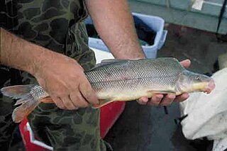
The razorback sucker is a suckerfish found in rivers and lakes in the southwestern United States and formerly northwestern Mexico. It can grow to 91 cm (3 ft) in length and is recognisable by the keel between its head and dorsal fin. It used to inhabit much of the Colorado River Basin but commercial fishing, river damming, and habitat loss have caused great declines in populations. It is now restricted to the Colorado River upstream of the Grand Canyon and to four reservoirs, Lake Mead, Lake Mohave, Lake Havasu, and Lake Powell.

The Bill Williams River is a 46.3-mile-long (74.5 km) river in west-central Arizona where it, along with one of its tributaries, the Santa Maria River, form the boundary between Mohave County to the north and La Paz County to the south. It is a major drainage westwards into the Colorado River of the Lower Colorado River Valley south of Hoover Dam and Lake Mead, and the drainage basin covers portions of northwest, and west-central Arizona. The equivalent drainage system paralleling the east–west lower reaches of the Bill Williams is the Gila River, which flows east-to-west across central Arizona, joining the Colorado River in the southwest at Yuma. The confluence of the Bill Williams River with the Colorado is north of Parker, and south of Lake Havasu City.

The Bill Williams River National Wildlife Refuge protects the lower course of the Bill Williams River, to its mouth at Lake Havasu reservoir, in western Arizona. It is located within eastern La Paz and Mohave Counties, in the Lower Colorado River Valley region.

Havasu National Wildlife Refuge is a U.S. National Wildlife Refuge on the lower Colorado River in Arizona and California. It preserves habitat for desert bighorn sheep, the endangered southwestern willow flycatcher, and other animals. The refuge protects 30 river miles - 300 miles (480 km) of shoreline - from Needles, California, to Lake Havasu City, Arizona. One of the last remaining natural stretches of the lower Colorado River flows through the 20-mile-long (32 km) Topock Gorge.

The San Bernardino National Wildlife Refuge is located on the U.S.-Mexico border in Cochise County, Arizona. Situated at 3,720 to 3,920 feet (1,130–1,190 m) elevation in the bottom of a wide valley, the refuge encompasses a portion of the headwaters of the Yaqui River, which drains primarily western Chihuahua and eastern Sonora, Mexico. The 2,309-acre (9.34 km2) ranch was acquired by the U.S. Fish and Wildlife Service in 1982 to protect the water resources and provide habitat for endangered native fishes.
The Pierce National Wildlife Refuge is in southwest Washington within the Columbia River Gorge National Scenic Area. It encompasses wetlands and uplands along the north shore of the Columbia River west of the town of North Bonneville. Refuge habitats include wetlands, Columbia River riparian corridor blocks, transitional woodlands from willows to cottonwood/ash to white oak to Douglas fir, improved pastures with some native grasses, and numerous creeks, seeps, and springs.

The Sacramento Wash is a major drainage of northwest Arizona in Mohave County. The wash is east of the Black Canyon of the Colorado and drains into the south-flowing Colorado River 45 mi south of Lake Mohave, and 90 mi south of Hoover Dam at Lake Mead. The wash outfall is in the center-south of the Havasu-Mohave Lakes Watershed. An equivalent wash drains to the west of the Colorado River and the Black Canyon, draining southeast Nevada and a small part of California, the Piute Wash of the Piute Valley. The Piute Wash outfall is upstream of the Sacramento's outfall by about 15 miles.

The Mohave Mountains are a small 18-mi (29 km) long mountain range of northwest Arizona. The range is a northwest trending range in southwest Mohave County that parallels a southeast-flowing stretch of the Colorado River, the Arizona-California border. The range also forms the southwest border of a flatland region to its east and north, namely, Dutch Flat which lies east, at the south end of Sacramento Valley. Lake Havasu City, AZ on the Colorado, lays opposite the southwest flank of the range, where the London Bridge was reconstructed at Lake Havasu.

The Colorado River is a major river of the western United States and northwest Mexico in North America. Its headwaters are in the Rocky Mountains where La Poudre Pass Lake is its source. Located in north central Colorado it flows southwest through the Colorado Plateau country of western Colorado, southeastern Utah and northwestern Arizona where it flows through the Grand Canyon. It turns south near Las Vegas, Nevada, forming the Arizona–Nevada border in Lake Mead and the Arizona–California border a few miles below Davis Dam between Laughlin, Nevada and Needles, California before entering Mexico in the Colorado Desert. Most of its waters are diverted into the Imperial Valley of Southern California. In Mexico its course forms the boundary between Sonora and Baja California before entering the Gulf of California. This article describes most of the major features along the river.

The Mohave Canyon is located on the Colorado River, south of Needles, California. It is part of Topock Gorge, a mountainous canyon and gorge section of the Colorado River located between Interstate 40 and Lake Havasu.
The Needles are a distinctive group of rock pinnacles, mountain peaks adjacent to the Topock Gorge, and the Colorado River on the northwestern extreme of the Mohave Mountains within the Havasu National Wildlife Refuge in Mohave County, Arizona, United States. They range from 1207 to over 1600 feet in altitude.

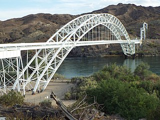
The Red Rock Bridge was a bridge across the Colorado River at Topock, Arizona that carried the Atlantic & Pacific Railroad. It was built in 1890, replacing a wooden bridge dating to 1883 that was repeatedly washed out during spring flooding. It was used by the railroad until 1945 when a new bridge was built. The Red Rock Bridge was then converted to carry the automobile traffic of U.S. Route 66, and did so from 1947 until 1966 when Route 66 traffic was directed onto the Interstate 40 bridge. At that time the Red Rock Bridge was abandoned, and it was eventually dismantled in 1976.
Washington Maritime National Wildlife Refuge Complex is an administrative grouping of six National Wildlife Refuges in Washington, managed by the United States Fish and Wildlife Service. It includes:
