Related Research Articles

South Mountain Park in Phoenix, Arizona is the largest municipal park in the United States, and one of the largest urban parks in North America and in the world. It has been designated as a Phoenix Point of Pride.

The South Mountains, known locally as simply South Mountain, is a mountain range in central Arizona in south Phoenix, Arizona. It is on public land managed by the city of Phoenix as South Mountain Park.

San Ignacio is a palm oasis town in Mulegé Municipality of northern Baja California Sur state in Mexico.

The Yuma Desert is a lower-elevation section of the Sonoran Desert in the southwestern United States and the northwest of Mexico. It lies in the Salton basin. The desert contains areas of sparse vegetation and has notable areas of sand dunes. With an average rainfall less than 8 inches (200 mm) each year, this is among the harshest deserts in North America. Human presence is sparse throughout, the largest city being Yuma, Arizona, on the Colorado River and the border of California.

Ironwood Forest National Monument is located in the Sonoran Desert of Arizona. Created by Bill Clinton by Presidential Proclamation 7320 on June 9, 2000, the monument is managed by the Bureau of Land Management, an agency within the United States Department of the Interior. The monument covers 129,055 acres (52,227 ha), of which 59,573 acres (24,108 ha) are non-federal and include private land holdings and Arizona State School Trust lands.

Canotia holacantha, also known as crucifixion thorn or simply canotia, is a flowering shrub / small tree in the family Celastraceae. It is the only species in the genus Canotia.
Juniperus coahuilensis, commonly known as redberry juniper, is a species of conifer in the family Cupressaceae.

Bursera microphylla, known by the common name elephant tree in English or 'torote' in Spanish, is a tree in genus Bursera. It grows into a distinctive sculptural form, with a thickened, water-storing or caudiciform trunk. It is found in the southwestern United States and northwestern Mexico.

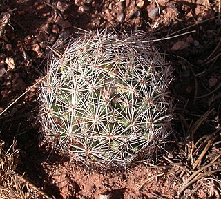
Escobaria vivipara is a species of cactus known by several common names, including spinystar, viviparous foxtail cactus, pincushion cactus and ball cactus. It is native to North America, where certain varieties can be found from Mexico to Canada. Most of these varieties are limited to the Mojave and Sonoran Deserts.

The Tinajas Altas Mountains are an extremely arid northwest-southeast trending mountain range in southern Yuma County, Arizona, approximately 35 mi southeast of Yuma, Arizona. The southern end of the range extends approximately one mile into the northwestern Mexican state of Sonora on the northern perimeter of the Gran Desierto de Altar. The range is about 22 mi in length and about 4 mi wide at its widest point. The highpoint of the range is unnamed and is 2,766 feet above sea level and is located at 32°16'26"N, 114°02'48"W. Aside from the portion of the range in Mexico, the entirety of the range lies within the Barry M. Goldwater Air Force Range. They lie at the heart of the traditional homeland of the Hia C-eḍ O'odham people.

The Gila Mountains of Yuma County are a 26-mile (42 km) long mountain range in southwestern Arizona in the northwest Sonoran Desert.

The Pinacate Peaks are a group of volcanic peaks and cinder cones located mostly in the Mexican state of Sonora along the international border adjacent to the U.S. state of Arizona, surrounded by the vast sand dune field of the Gran Desierto de Altar, at the desert's southeast.
The Sierra de San Francisco is a mountain range in Mulegé Municipality of the northern region of Baja California Sur state, in northwestern Mexico.

Bursera fagaroides is a species of flowering plant in the genus Bursera known by the common names torchwood copal and fragrant bursera. It is widespread across much of Mexico from Sonora to Oaxaca, and its range extends just into Arizona in the United States, although some sources suggest that it may now be extirpated in Arizona.

The Waterman Mountains are a low mountainous landform in Pima County, United States. Notable among the tree species is the elephant tree which species exhibits a contorted multi-furcate architecture; most of these froze in the cold winter of 2011. The Waterman Mountain range is in the Ironwood Forest National Monument.
Monardella arizonica is a plant species endemic to Arizona in the United States, known by the common name Arizona monardella.

Opuntia chlorotica is a species of plant in the family Cactaceae. It is a species of prickly pear native to the southwestern United States and northern Mexico. Its common names include pancake prickly pear, flapjack prickly pear and dollarjoint prickly pear.

Vauquelinia californica, commonly known as Arizona rosewood, is an evergreen species of shrub or tree, in the rose family, Rosaceae.

Salvia pinguifolia is a species of flowering plant in the family Lamiaceae that is native to southern Arizona, southern New Mexico, and western Texas in the United States as well as Chihuahua in Mexico. It inhabits rocky slopes at elevations of 2,000–7,000 ft (610–2,130 m). The specific name is derived from the Latin words pinguis, meaning, "grease", and folium, meaning "leaf," referring to the texture of the leaves. Leaf shape is ovate-deltoid to oblong elliptical. S. pinguifolia had a greater range during the Late Wisconsin glacial period; for example, it was present in the Waterman Mountains of southeastern Arizona in that earlier epoch, but is no longer extant there.
Myriopteris windhamii, formerly known as Cheilanthes villosa, is a species of lip fern, known as villous lipfern. This plant is native to the southwestern United States where it grows in rocky mountains and deserts. For example, it is found along with the elephant tree, Bursera microphylla, and other desert species in the Waterman Mountains of southeastern Arizona.
References
| Wikimedia Commons has media related to Tule Mountains . |
- Will Croft Barnes and Byrd H. Granger. 1960. Arizona place names, p. 511
- C. Michael Hogan. 2009. Elephant Tree: Bursera microphylla, GlobalTwitcher.com, ed. N. Stromberg