Poston Butte

Last updated
Poston Butte
PostonButte.jpg
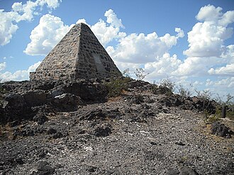
Poston Butte, with Poston's pyramidal tomb at the peak
Highest point
Elevation 1,749 ft (533 m)  NAVD 88 [1]
Prominence 223 ft (68 m) [2]
Coordinates 33°03′19″N111°24′32″W / 33.055199031°N 111.40892075°W / 33.055199031; -111.40892075 Coordinates: 33°03′19″N111°24′32″W / 33.055199031°N 111.40892075°W / 33.055199031; -111.40892075 [1]
Geography
USA Arizona relief location map.svg
Red triangle with thick white border.svg
Poston Butte
Location Pinal County, Arizona, U.S.
Topo map USGS Florence

Poston Butte, formerly called Primrose Hill, is a hill located along Hunt Highway in Florence, Pinal County, Arizona, United States, [3] near the eastern end of the Santan Mountains. [4] Geologically, it is characterized by basalts overlying altered granite. [5]

This hill is noted for having the pyramidal tomb of Charles Debrille Poston at its summit. Poston lobbied President Lincoln and Congress to create the Territory of Arizona [6] and was appointed Superintendent of Indian Affairs because of his familiarity with the Native populations of the area. [7] The tomb can be accessed by a 0.6-mile (0.97 km) trail starting from the trailhead near Hunt Highway. [8]

Related Research Articles

<span class="mw-page-title-main">Florence, Arizona</span> Town in Pinal County, Arizona

Florence is a town, 61 miles (98 km) southeast of Phoenix, in Pinal County, Arizona, United States. Florence, which is the county seat of Pinal County, is one of the oldest towns in that county and is regarded as a National Historic District with over 25 buildings listed on the National Register of Historic Places. The population of Florence was 26,785 at the 2020 census.

<span class="mw-page-title-main">Mount Graham</span> Mountain in Arizona, United States

Mount Graham is a mountain in Graham County, Arizona, United States, approximately 70 miles (110 km) northeast of Tucson. The mountain reaches 10,724 feet (3,269 m) in height. It is the highest elevation in Graham County, Coronado National Forest and the Pinaleño Mountains. It is also the southernmost peak and land area in the continental United States above 10,000 feet (3,048 m). As the name "Mount Graham" is often used by locals to refer to the entire mountain range, the peak itself is frequently referred to as "High Peak". It is twentieth of the 57 ultra prominent peaks of the lower 48 states, and the first of the five in Arizona.

<span class="mw-page-title-main">Mount Lemmon</span> Mountain in Arizona, United States

Mount Lemmon, with a summit elevation of 9,159 feet (2,792 m), is the highest point in the Santa Catalina Mountains. It is located in the Coronado National Forest north of Tucson, Arizona, United States. Mount Lemmon was named for botanist Sara Plummer Lemmon, who trekked to the top of the mountain with her husband and E. O. Stratton, a local rancher, by horse and foot in 1881. Mount Lemmon is also known as Babad Do'ag, or Frog Mountain to the Tohono O'odham.

<span class="mw-page-title-main">Hunts Mesa</span> Landform in Monument Valley, US

Hunts Mesa is a rock formation located in Monument Valley, south of the border between Utah and Arizona in the United States and west of the border between Arizona's Navajo County and Apache County. It is one of two popular interior destinations in the Monument Valley Navajo Tribal Park for tourists to experience panoramic views of the popular sandstone formations from a distance. The other is Mystery Valley. A Navajo guide is required to hike to either.

<span class="mw-page-title-main">Fort Bowie</span> 19th-century US Army outpost in Arizona

Fort Bowie was a 19th-century outpost of the United States Army located in southeastern Arizona near the present day town of Willcox, Arizona. The remaining buildings and site are now protected as Fort Bowie National Historic Site.

<span class="mw-page-title-main">Charles Debrille Poston</span> Early Arizona politician (1825–1902)

Charles Debrille Poston was an American explorer, prospector, author, politician, and civil servant. He is referred to as the "Father of Arizona" due to his efforts lobbying for creation of the territory. Poston was also Arizona Territory's first Delegate to the U.S. House of Representatives.

<span class="mw-page-title-main">Mount Baldy (Arizona)</span> Mountain in Apache County, Arizona, United States

Mount Baldy is a mountain in eastern Arizona in the United States. With a summit elevation of 11,409 feet (3,477 m), the peak of Mount Baldy rises above the tree line and is left largely bare of vegetation, lending the mountain its current name. The Mount Baldy Wilderness occupies the eastern slope of the mountain and is managed by the Apache-Sitgreaves National Forest.

<span class="mw-page-title-main">Escudilla Mountain</span> Landform in Apache County, Arizona

Escudilla Mountain is located in Apache County, Arizona, and is part of the White Mountains. The peak is approximately 3.5 miles from the Arizona-New Mexico border. The summit is the highest point in the Escudilla Wilderness which is administered as part of the Apache-Sitgreaves National Forest.

<span class="mw-page-title-main">Black River (Arizona)</span> Waterway in Arizona, United States

The Black River is a 114-mile-long (183 km) river in the White Mountains of the U.S. state of Arizona. It forms south of the town of Greer and west of the towns of Nutrioso and Alpine. The river flows southwest then northwest to meet the White River west of Fort Apache. The merged streams form the Salt River, a major tributary of the Gila River. Both the Salt and Gila rivers supply water to the Phoenix metro area as well as provides water for farmland and crops around the valley.

<span class="mw-page-title-main">Bell Rock (Arizona)</span> Landmark near Sedona, Arizona

Bell Rock is a butte just north of the Village of Oak Creek, Arizona, south of Sedona in Yavapai County. With an elevation at its summit of 4,919 feet (1,499 m), it is just west of Courthouse Butte. Its panoramic views make it a popular landmark and tourist attraction.

Cerro Colorado is a ghost town in southern Pima County, Arizona. The town is located off Arivaca Road, near Arivaca, and is best known for the massacre of mining employees by Mexican outlaws and buried treasure.

<span class="mw-page-title-main">Agua Caliente, Arizona</span> Former resort in Maricopa County, Arizona

Agua Caliente in Maricopa County, Arizona on the border with Yuma County, is a place north of the Gila River near Hyder, Arizona. Named 'Santa Maria del Agua Caliente' in 1744 by Father Jacob Sedelmayer. In 1775, Father Francisco Garces used the current short form. The location was the site of a resort established at the site of nearby hot springs. Agua Caliente, a name derived from Spanish meaning "hot water", received its name from nearby hot springs which were originally used by the local Indians.

<span class="mw-page-title-main">Newton Butte</span> Prominence in the Grand Canyon, Arizona, United States

Newton Butte, in the Grand Canyon, Arizona, United States is a prominence below the South Rim, northwest of Grandview Point, and north on a ridgeline from Shoshone Point which is one mile east of Yaki Point, East Rim Drive. Shoshone Point and Yaki are both on access roads from East Rim Drive, with Yaki being the more advantageous to different viewing directions.

The White River is a 16-mile (26 km) tributary of the Salt River in the U.S. state of Arizona. Formed by two forks that drain part of the White Mountains, it begins in Navajo County and ends in Gila County, where it meets the Black River to form the Salt River.

<span class="mw-page-title-main">Gavilan Peak (Arizona)</span> Landform in Maricopa County, Arizona

Gavilan Peak is northwest of Daisy Mountain, north of Anthem, Arizona and southeast of New River, Arizona. Considering its steepness, it is climbed much less frequently than Daisy Mountain. It was named in the 1880s, when the U.S. Cavalry and the Apaches fought a battle in the area. The name means 'sparrow hawk' in Spanish and 'hawk' in Apache.

<span class="mw-page-title-main">Highland Park, Yavapai County, Arizona</span> Populated place in Arizona, United States

Highland Pines is a populated place in Township 14N, Range 3W Gila and Salt River Meridian, situated near Prescott and within the Prescott National Forest, in Yavapai County, Arizona, United States. Highland Park is the unofficial map reference for the locality. Highland Pines is the promotional name associated with the Highland Park areas several subdivisions. In the Arizona Territorial era up to 1912, and Statehood until around the late 1920s, this particular area of land acted as a cattle ranch with a mining history, lies within the Thumb Butte Mining District, which appears to be initially platted by the Arizona Corporation Highland Pine Properties Inc. beginning in the late 1950s.

Hunt is a populated place situated on the Little Colorado River at the mouth of Concho Creek in Apache County, Arizona, United States. It is named after Colonel James Hunt, who served at Fort Apache in the 1870s. It has an estimated elevation of 5,433 feet (1,656 m) above sea level.

References

  1. 1 2 "Poston". NGS Data Sheet. National Geodetic Survey, National Oceanic and Atmospheric Administration, United States Department of Commerce . Retrieved 2014-02-08.
  2. "Poston Butte AZ". ListsOfJohn.com. Retrieved 2016-08-19.
  3. "Poston Butte". Geographic Names Information System . United States Geological Survey, United States Department of the Interior . Retrieved 2014-02-08.
  4. "Poston Butte". AZGS Document Repository. Retrieved 2014-02-08.
  5. "Poston, Butte-Mineral, Eutte-Sacaton: Fall Field Trip" (PDF). Arizona Geological Society. November 11, 1973. Retrieved 2014-02-08.
  6. Poston, Charles D. "Building a State in Apache Land". p. 31. Retrieved 2014-02-08.
  7. Poston, Charles D. "Building a State in Apache Land". p. 32. Retrieved 2014-02-08.
  8. "Poston's Butte – Florence, AZ". HikeArizona.com. Retrieved 2014-02-08.